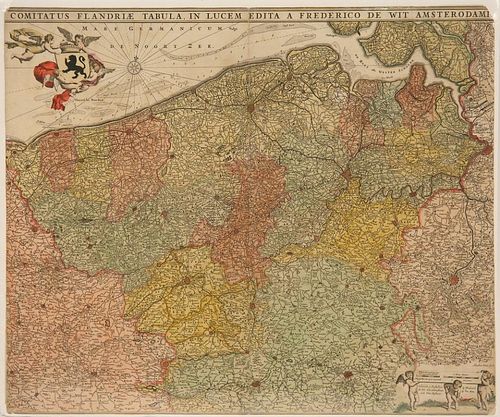
RARE MAP
Lot 3283
Estimate:
$500 - $700
Absentee vs Live bid
Two ways to bid:
- Leave a max absentee bid and the platform will bid on your behalf up to your maximum bid during the live auction.
- Bid live during the auction and your bids will be submitted real-time to the auctioneer.
Bid Increments
| Price | Bid Increment |
|---|---|
| $0 | $10 |
| $100 | $25 |
| $500 | $50 |
| $1,000 | $100 |
| $2,500 | $250 |
| $5,000 | $500 |
| $10,000 | $1,000 |
| $15,000 | $2,500 |
| $50,000 | $5,000 |
| $100,000 | $10,000 |
About Auction
By Thomaston Place Auction Galleries
Mar 29, 2017 - Mar 30, 2017
Set Reminder
2017-03-29 11:00:00
2017-03-30 11:00:00
America/New_York
Bidsquare
Bidsquare : ONLINE-ONLY AUCTION MARCH 2017
https://www.bidsquare.com/auctions/thomaston-place/online-only-auction-march-2017-2225
Thomaston Place Auction Galleries info@thomastonauction.com
Thomaston Place Auction Galleries info@thomastonauction.com
- Lot Description
De Wit, Frederick, 'Comitatus Flandriae Tabula in lucem edita a Frederico De Wit Amsterodami', published in Amsterdam, 1680, original hand-coloring, trimmed to edge, 17 7/8" x 21 1/2", shrinkwrapped over foam core. Depicts Flanders, the whole Belgian region northwest of Brussels, confined by Antwerp, Brussels, Valenciennes, Arras, St. Omer and the Channel. Title heading above the map, coat of arms supported by cherubs, and scale of miles, towns highlighted in red. Koeman III, p 213, map 53. Good condition.
- Buyer's Premium


 EUR
EUR CAD
CAD AUD
AUD GBP
GBP MXN
MXN HKD
HKD CNY
CNY MYR
MYR SEK
SEK SGD
SGD CHF
CHF THB
THB


