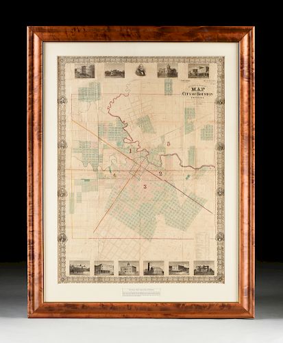
AN ANTIQUE RECONSTRUCTION ERA MAP, "Kosse & Scott's Map of the City of Houston and Environs," 1867,
About Seller
6116 Skyline Drive, Suite 1
Houston, TX 77057
United States
Simpson Galleries has been serving Houston’s need for the very best in antique sales venues for more than fifty years. Beginning in 1962, William Simpson started educating himself and others in the art of collecting fine antiques and art objects. Simpson Galleries' commitment to excellence and accur...Read more
Two ways to bid:
- Leave a max absentee bid and the platform will bid on your behalf up to your maximum bid during the live auction.
- Bid live during the auction and your bids will be submitted real-time to the auctioneer.
Bid Increments
| Price | Bid Increment |
|---|---|
| $0 | $25 |
| $500 | $50 |
| $1,000 | $100 |
| $2,000 | $250 |
| $5,000 | $500 |
| $10,000 | $1,000 |
| $20,000 | $2,500 |
| $50,000 | $5,000 |
| $100,000 | $10,000 |
| $200,000 | $25,000 |
About Auction
Sep 21, 2019
European avant-garde and German Expressionist printmaking from the family of collector Ismar Littmann including examples from Manet, Renoir, Kollwitz, and a compilation following the career of artist Max Pechstein. Texas and regional art is well represented, as well as, historically significant maps Simpson Galleries online_auctions@simpsongalleries.com
- Lot Description
AN ANTIQUE RECONSTRUCTION ERA MAP, "Kosse & Scott's Map of the City of Houston and Environs," 1867, hand colored engraving on paper, compiled and drawn by Theo. Kosse, Civil Engineer, "With Advertising assistance Mess. Will Powers, Geo. H. Bringhurst, Surveyor, W.R. Baker...," showing the five wards of Houston subdivided into resident housing lots; White Oak and Buffalo Bayou meander through the city, recognizable street names like Pease, Leeland, Richmond, Travis, Milam, Congress, Franklin, Preston, Prairie and Texas Streets are laid around the Courthouse, with areas yet undeveloped labeled by their land owners names such as H.H. Allen, Bush, T.M. Anderson, F.A. Rice, H.H. Milby, Onderdonk, Branard, Kirkland, Kuhlman; southern third ward with unusual hand written in pencil "Emancipation Lands," a single notation for a City Hospital, four railroad lines in the city include Texas & New Orleans; Houston & Texas Central; Galveston, Houston & Henderson; and Houston & Brazoria; south of the bayous are City, Episcopal, Masonic and Catholic Cemeteries; the map bordered by lattice rocaille and Texas Star medallions interspersed by engraved early Houston portrait medallions of A.C. Allen, T.M. Bagby, J.S. Holeman, and F. R. Lubbock, Sam L. Allen, W.R. Baker, T.W. House, W.J. Hutchins, and engravings of notable architectural landmarks of the Wm. J. Hutchins and E.H. Cushing residences, Hutchins Corner, Houston Academy, Christ's Episcopal Church, Perkin's Corner, Morris Building, Court House, the Old Capitol and the corner at Main & Commerce streets, in the lower right corner a reference chart denotes local hotels, schools, churches and the firehouse. 49" x 36" Note: The unusual hand penciled inscriptions suggest that lands in Houston were bought and sold rapidly during Reconstruction, and it could be suggested that the present map was likely used to maintain a clear idea of the most up to date land ownership. The "Emancipation Lands," penciled in area, if period to the map, likely predates the 1872 known establishment of modern day Emancipation Park in Houston Texas' historic Third Ward. In a comparison to a later map from 1869 by W.E. Wood, the later map shows that the names Kohlman and Steenberg are printed within the map (the same penciled in names off Hadley St in the present 1867 map), however Emancipation Park is concealed by border engravings. This curious difference, though small, suggests an important historical consideration for Houstonians. The deed records also reflect a concentrated effort between elders of Trinity Methodist Church and Jack Yates to establish the park before the known 1872 date. The efforts of the recently freed slaves in establishing the park immediately after the Civil War is an important connection for modern Texans to recognize as a unique and immensely historically important contribution to the Houston community that has existed in perpetuity since the park was established. Maps of this significance and rarity are something to take note of, as they reveal a great deal of knowledge, otherwise yet uncovered. Provenance: Property from a Fortune 500 Energy Company, Houston, Texas.Fine hand coloring and pencil inscriptions and markings, creasing as issued, waves, bends, wrinkles and crinkling of paper, some toning, tape and or tape residue, minor holes and losses, but overall in good to very good condition, wear commensurate with age and use. Simpson Galleries strongly encourages in-person inspection of items by the bidder. Statements by Simpson Galleries regarding the condition of objects are for guidance only and should not be relied upon as statements of fact and do not constitute a representation, warranty, or assumption of liability by Simpson Galleries. All lots offered are sold "AS IS."
Condition
- Shipping Info
-
**SIMPSON GALLERIES, LLC. DOES NOT PROVIDE SHIPPING SERVICES OR SHIPPING QUOTES.** Shipping may be secured through - The UPS Store: store2567@theupsstore.com 281-764-9551, The UPS Store: store3229@theupsstore.com 713-334-8869, PACK-N-SEND: sales@pack-n-send.com 713-266-1450, ACTS Crating and Transportation Services: crating@actsintl.com 713-869-2269, NAVIS Pack & Ship: 17013tx@gonavis.com 713-352-3038, Wintersteen Trucking: wintersteentrucking@yahoo.com 800-253-0617, or the shipper of your choice.
-
- Buyer's Premium


 EUR
EUR CAD
CAD AUD
AUD GBP
GBP MXN
MXN HKD
HKD CNY
CNY MYR
MYR SEK
SEK SGD
SGD CHF
CHF THB
THB


