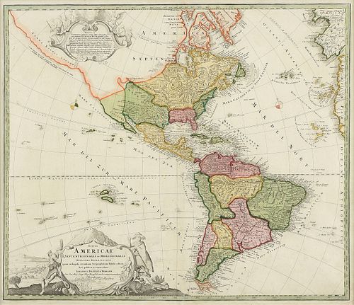
AN ANTIQUE MAP, "Totius Americae Septentrionalis et Meridionalis," NUREMBERG, EARLY 18TH CENTURY,
About Seller
6116 Skyline Drive, Suite 1
Houston, TX 77057
United States
Simpson Galleries has been serving Houston’s need for the very best in antique sales venues for more than fifty years. Beginning in 1962, William Simpson started educating himself and others in the art of collecting fine antiques and art objects. Simpson Galleries' commitment to excellence and accur...Read more
Two ways to bid:
- Leave a max absentee bid and the platform will bid on your behalf up to your maximum bid during the live auction.
- Bid live during the auction and your bids will be submitted real-time to the auctioneer.
Bid Increments
| Price | Bid Increment |
|---|---|
| $0 | $25 |
| $500 | $50 |
| $1,000 | $100 |
| $2,000 | $250 |
| $5,000 | $500 |
| $10,000 | $1,000 |
| $20,000 | $2,500 |
| $50,000 | $5,000 |
| $100,000 | $10,000 |
| $200,000 | $25,000 |
About Auction
Feb 16, 2020
Including important Maps, Audubon Havell prints; works by artists Lee N. Smith, Billy Hassell, Frank Reaugh, Porfirio Salinas, Richard MacDonald, Tsing-Fang Chen, Charles Schorre, Leroy Neiman, and Arman; and a painting by the fourth man to walk on the moon, Alan Bean. Simpson Galleries online_auctions@simpsongalleries.com
- Lot Description
AN ANTIQUE MAP, "Totius Americae Septentrionalis et Meridionalis," NUREMBERG, EARLY 18TH CENTURY, hand colored engraving on paper, published by Johann Baptist Homann (1664-1724), the figural title cartouche showing a North American Indian with Dutch windmills and settled farmland at his back and at left a South American Indian, and at center a scene of Trade between Indigenous and Explorers, duly noted are the personal weapons of war, and two types of armadillos. 20" x 23" Note: Johann Baptist Homann (March 20, 1664 - July 1, 1724) was the most prominent and prolific map publisher of the 18th century. Homann was born in Oberkammlach, a small town near Kammlach, Bavaria, Germany. As a young man Homann studied in a Jesuit school and nursed ambitions of becoming a Dominican priest before converting to Protestantism in 1687. Following his conversion, Homann moved to Nuremberg and found employment as a notary. Around 1693 Homan briefly relocated to Vienna, where he lived and studied printing and copper plate engraving until 1695. Afterwards he returned to Nuremberg where, in 1702, he founded the commercial publishing firm that would bear his name. In the next five years Homann produced hundreds of maps and developed a distinctive style characterized by heavy detailed engraving, elaborate allegorical cartouche work, and vivid hand color. The Homann firm, due to the lower cost of printing in Germany, was able to undercut the dominant French and Dutch publishing houses while matching the diversity and quality of their output. By 1715 Homann's rising star caught the attention of the Holy Roman Emperor Charles the VI, who appointed him Imperial Cartographer. In the same year he was also appointed a member of the Royal Academy of Sciences in Berlin. Homann's prestigious title came with a number of important advantages including access to the most up to date cartographic information as well as the "Privilege." The Privilege was a type of early copyright offered to a few individuals by the Holy Roman Emperor. Though not as sophisticated as modern copyright legislation, the Privilege did offer a kind of limited protection for several years. Most all J. B. Homann maps printed between 1715 and 1730 bear the inscription "Cum Priviligio" or some variation. Following Homann's death in 1726, the management of the firm passed to his son Johann Christoph Homann. The present map shows settlements, physical features, political divisions in North and South America and the West Indies; a portion of the coasts of Europe and Africa; islands in the Atlantic and Pacific Oceans, and settlements. Includes notes, dates of discovery, and illustrations.Mild expected wear, but overall in very good condition, wear commensurate with age. Simpson Galleries strongly encourages in-person inspection of items by the bidder. Statements by Simpson Galleries regarding the condition of objects are for guidance only and should not be relied upon as statements of fact and do not constitute a representation, warranty, or assumption of liability by Simpson Galleries. All lots offered are sold "AS IS."
Condition
- Shipping Info
-
**SIMPSON GALLERIES, LLC. DOES NOT PROVIDE SHIPPING SERVICES OR SHIPPING QUOTES.** Shipping may be secured through - The UPS Store: auctions@epicpartnershipco.com 281-764-9551, The UPS Store: store3229@theupsstore.com 713-334-8869, PACK-N-SEND: sales@pack-n-send.com 713-266-1450, ACTS Crating and Transportation Services: crating@actsintl.com 713-869-2269, NAVIS Pack & Ship: 17013tx@gonavis.com 713-352-3038, Wintersteen Trucking: wintersteentrucking@yahoo.com 800-253-0617, or the shipper of your choice.
-
- Buyer's Premium


 EUR
EUR CAD
CAD AUD
AUD GBP
GBP MXN
MXN HKD
HKD CNY
CNY MYR
MYR SEK
SEK SGD
SGD CHF
CHF THB
THB


