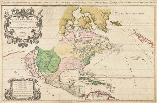
A LOUIS XIV MAP, "L'Amerique Septentrionale," HUBERT JAILLOT, PARIS, 1696,
About Seller
6116 Skyline Drive, Suite 1
Houston, TX 77057
United States
Simpson Galleries has been serving Houston’s need for the very best in antique sales venues for more than fifty years. Beginning in 1962, William Simpson started educating himself and others in the art of collecting fine antiques and art objects. Simpson Galleries' commitment to excellence and accur...Read more
Two ways to bid:
- Leave a max absentee bid and the platform will bid on your behalf up to your maximum bid during the live auction.
- Bid live during the auction and your bids will be submitted real-time to the auctioneer.
Bid Increments
| Price | Bid Increment |
|---|---|
| $0 | $25 |
| $500 | $50 |
| $1,000 | $100 |
| $2,000 | $250 |
| $5,000 | $500 |
| $10,000 | $1,000 |
| $20,000 | $2,500 |
| $50,000 | $5,000 |
| $100,000 | $10,000 |
| $200,000 | $25,000 |
About Auction
Sep 20, 2020
Including a rare document collection; clocks and timepieces; works by Porfirio Salinas, Frederic Remington, Édouard Cortès, Dorothy Hood, François Gall, Charles Russell, Peter Hurd, Henriette Wyeth, Mitchell Johnson, Gary Niblett and Frank Tenney Johnson; and French, English and American furniture. Simpson Galleries online_auctions@simpsongalleries.com
- Lot Description
A LOUIS XIV MAP, "L'Amerique Septentrionale," HUBERT JAILLOT, PARIS, 1696, hand colored engraving on paper, "Divisée en ses principals parties, ou sont distingués les uns des autres Les Estats suivant qu'ils appartiennent présentement aux François, Castillans, Anglois, Suedois, Danois, Hollandos, Tirée des Relations de toutes ces nations. Par le Sr. Sanson geographe ordinair du Roy.," Présentée à Monseigneur Dauphin, parson tres humble tres obeissant, et tres fidele serviteur, Hubert Jaillot.," the title cartouche centering a royal crown over the Coat of Arms of the Dauphin of France within baroque scrolls, fruits, and perched parrot and cockatiel, the sides upheld by two terminal figures modeled after John Smith's earlier published 1612 depictions of Powhatan in his court lodge; the female draped in beads holds a recurve bow and arrow, the male with a bead and feather collar and sash upholds a war club, below a grotesque issued from feathery mustached nostrils flanked by an armadillo and bobcat, the mile chart with seated figures of war, one shown in the reverse and the other wearing a shield and shell arm and leg bands centering fruiting cornucopia, the border with scale of sea leagues and half leagues and the map overlaid with latitude and longitude lines. 22 1/2" x 34 1/2" Note: Created for use by the Monseigneur le Dauphin, son to King Louis XIV, after Nicolas Sanson's original map. This edition uniquely points out the seat of the Powhatan Confederation located in Virginia. Jaillot spells the seat of Algonquin power "Pou'hatan" in French and places it on a small arm of the York River, just north of the labeled "Powhatan" river. This is likely the site of "Werowocomoco." The French cartographer acknowledges the indigenous culture before the English territorial claim of the Tidewater Region of colonial Virginia. The seat of "Pou'hatan" does not appear on Sanson's earlier version of this map, and is an update that Jaillot added. The Tidewater Region of Virginia was an area destined to become a crucial land space in early colonial American history. The Dauphin died before inheriting the throne, just fifteen years after this map was published. A rapidly changing "New World" is drawn incorrectly with an island California and unfinished northeastern coastline.Some creasing and mild tear at margins near neat line, mild fading of hand color, some toning and foxing, but overall in good to very good condition, wear commensurate with age and use. Simpson Galleries strongly encourages in-person inspection of items by the bidder. Statements by Simpson Galleries regarding the condition of objects are for guidance only and should not be relied upon as statements of fact and do not constitute a representation, warranty, or assumption of liability by Simpson Galleries. All lots offered are sold "AS IS." NO REFUNDS will be issued based on condition.
Condition
- Shipping Info
-
**SIMPSON GALLERIES, LLC. DOES NOT PROVIDE SHIPPING SERVICES OR SHIPPING QUOTES.** Shipping may be secured through - The UPS Store: auctions@epicpartnershipco.com 281-764-9551, The UPS Store: store1733@theupsstore.com 713-942-7775, PACK-N-SEND: sales@pack-n-send.com 713-266-1450, ACTS Crating and Transportation Services: crating@actsintl.com 713-869-2269, NAVIS Pack & Ship: 17013tx@gonavis.com 713-352-3038, A Better Mover Inc: travis@abettermoverinc.com or abettermover@yahoo.com 404-754-0111, or the shipper of your choice. We are open for shipper pick-up Tuesday - Thursdays from 10 am to 3 pm or by appointment.
-
- Buyer's Premium


 EUR
EUR CAD
CAD AUD
AUD GBP
GBP MXN
MXN HKD
HKD CNY
CNY MYR
MYR SEK
SEK SGD
SGD CHF
CHF THB
THB


