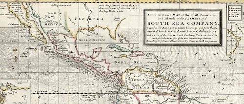
South Sea Company map of South America
Lot 27
About Seller
The Old Print Shop, Inc
150 Lexington Avenue
New York, NY 10016
United States
The Old Print Shop, Inc. was founded in New York City in 1988. Specialist art gallery in American art including painting, drawing and printmaking from 1700 to contemporary, antique maps and atlases, artist's books and reference books. Our staff and owners are experts in American art, assist in colle...Read more
Categories
About Auction
By The Old Print Shop, Inc
Jun 5, 2017 - Jun 19, 2017
Set Reminder
2017-06-05 08:00:00
2017-06-19 20:30:00
America/New_York
Bidsquare
Bidsquare : Cartographic wonders
https://www.bidsquare.com/auctions/old-print-shop/cartographic-wonders-2417
The Old Print Shop, Inc info@oldprintshop.com
The Old Print Shop, Inc info@oldprintshop.com
- Lot Description
A New & Exact Map of the Coast, Countries and Islands within ye Limits of ye South Sea Company, from ye River Aranoca to Terra del Fuego, and from thence through ye South Sea, to ye North Part of California &c.
By Hermann Moll, London. c.1720.
Copper plate engraving.
Two sheet map, joined, image 25 3/4 x 18 7/8” (65.5 x 49.1 cm).
A two-sheet map depicting Central and South America with insets titled "A Chart from England to the River Aranoca &c", "Peypses or Pepys I", "A Map of ye Straits of Magellan &c", "A Map of the Isthmus of Darien The Bay of Panama &c", "The Island of Juan Ferdinando", "The Gallapagos Islands", "The Gulf of Amapalla", and "The Port of Acapulco". The insets "A Map of ye Port of Baldivia", "The Bay of Guiaquil &c", and "A Map of the Isle of Chiloe" are attached on the second sheet, along the top third of the map. The South Sea Company was a British joint-stock company founded in 1711 which had a monopoly to trade with South America as part of a treaty during the War of the Spanish Succession, when most of South America was under Spanish control. The South Sea Company’s profits and rising stock were meant to reduce the national debt, but political corruption and a stock collapse in 1720 known as the South Sea Bubble ultimately damaged the national economy. However, the South Sea Company was restructured and remained successful for more than a century after the collapse. This map labels ports and rivers in significant detail, and also marks mine locations, the directions of trade winds, the “sea limits” of the South Sea Company, European forts and settlements, and regions inhabited by Native American groups.Generally in good condition. Some splits along fold lines and occasional tear. All professionally repaired. Original outline hand color.Condition
- Shipping Info
-
The Old Print Ship, Inc.
150 Lexington Avenue
New York, NY 10016
-
- Buyer's Premium


 EUR
EUR CAD
CAD AUD
AUD GBP
GBP MXN
MXN HKD
HKD CNY
CNY MYR
MYR SEK
SEK SGD
SGD CHF
CHF THB
THB


