Rare Civil War Confederate inprint
Lot 14
About Seller
The Old Print Shop, Inc
150 Lexington Avenue
New York, NY 10016
United States
The Old Print Shop, Inc. was founded in New York City in 1988. Specialist art gallery in American art including painting, drawing and printmaking from 1700 to contemporary, antique maps and atlases, artist's books and reference books. Our staff and owners are experts in American art, assist in colle...Read more
Categories
About Auction
By The Old Print Shop, Inc
Jun 5, 2017 - Jun 19, 2017
Set Reminder
2017-06-05 08:00:00
2017-06-19 20:30:00
America/New_York
Bidsquare
Bidsquare : Cartographic wonders
https://www.bidsquare.com/auctions/old-print-shop/cartographic-wonders-2417
The Old Print Shop, Inc info@oldprintshop.com
The Old Print Shop, Inc info@oldprintshop.com
- Lot Description
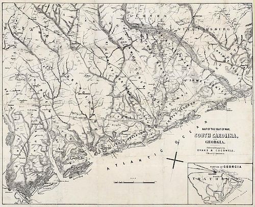
Map of the Seat of War, in South Carolina, and Georgia.
Published & Lithographed by Evans & Cogswell, 3 Broad St, Charleston. S.C. c.1861
Stone engraving.
Image 20 1/2 x 25 5/8" (52.1 x 65 cm) plus margins.
An extremely rare Confederate imprint. This unusual pocket map shows the coastal area from Georgetown, South Carolina, to Savannah, Georgia, and territory inland as far north as Kingstree, South Carolina, and west to Barnwell, South Carolina. Notes the location of forts, rivers, roads, railroads, ferries, bridges, dwellings with names of inhabitants, churches, and post offices. In the lower right is an inset map titled “Portion of Georgia” which shows Savannah and the nearby areas to the south and east. Drawn on a scale of one inch to five miles.
The firm of Walker, Evans & Cogswell was founded in Charleston in 1821. They were printers as well as stationers. In 1860 Walker died and the business continued as Evans & Cogswell. While the firm printed a handful of maps during their existence they are best remembered for printing the Ordinance of Secession. They also printed small denomination currency, Government bonds, the Soldier's Prayer Book, books on war tactics, stamps, and medical books for the Confederacy. Later in the war the firm moved to Columbia hoping for protection from the war. Soon after their move the business was burned during Gen. Sherman's infamous March to the sea. Very few examples are known to exist. Originally issued as a folding pocket map. This example lacks the original covers.
LC "Civil War Maps" 359.Fair to good condition. There is splitting along the fold lines and some minor losses along fold intersections. Upper right corner reattached. Professionally restored and backed on rice paper.Condition
- Shipping Info
-
The Old Print Ship, Inc.
150 Lexington Avenue
New York, NY 10016
-
- Buyer's Premium


 EUR
EUR CAD
CAD AUD
AUD GBP
GBP MXN
MXN HKD
HKD CNY
CNY MYR
MYR SEK
SEK SGD
SGD CHF
CHF THB
THB


