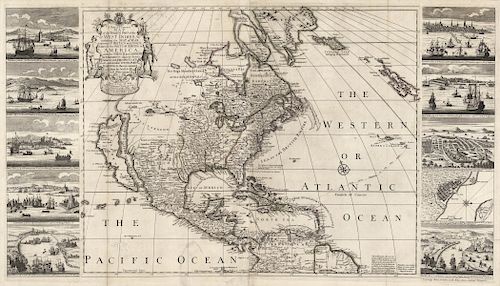
Important Map of America by Henry Overton - 1745
About Seller
150 Lexington Avenue
New York, NY 10016
United States
The Old Print Shop, Inc. was founded in New York City in 1988. Specialist art gallery in American art including painting, drawing and printmaking from 1700 to contemporary, antique maps and atlases, artist's books and reference books. Our staff and owners are experts in American art, assist in colle...Read more
About Auction
Mar 22, 2019 - Apr 6, 2019
Early Cartographic pieces, handsome 19th century Town Views, and works by John James Audubon, Karl Bodmer and McKenney & Hall. The Old Print Shop, Inc info@oldprintshop.com
- Lot Description
Title: A New & Correct Map of the Trading Part of the West Indies, including the Seat of War between Gr. Britain and Spain; Likewise the British Empire in America, with the French and Spanish Settlements adjacent thereto; Adorn'd with Prospects of ye. most considerable Towns, Ports, Harbours &c. therein contain'd from the latest & best Observations. 1745.
Cartographer: Henry Overton Printed for and sold by Henry Overton at the White Horse without Newgate, London.
Copper plate engraving, 1741. Printed 1745.
Image size 21 3/4 x 39 1/4" (55.2 x 99.7 cm) plus margins.
Text below the title reads, "Dedicated to the Honble. Edward Vernon Esqr. Vice Admiral of the Blue and Commander in chief of all his Maj.s. Ships in the West Indies, by H. O."
The views on the left panel are: “Havana, a famous Sea Port in the Isle of Cuba....”; “Panama, a City & Sea Port in N. America 'tis the treasury of ye Gold & Silver of Peru”; “Porto Rico, a City in N. America at the W. end of an Island of ye same name subject to the K. of Spain”; “Cartagena, a famous City in North America subject to the King of Spain”; “Porto Bello, a City & Sea Port in N. America taken by Ad. Vernon on 22d. Novr. 1739, about 20 Leagues from Panama.”
The views on the right panel are: “Boston a Town in N. America in N. England & ye Plantation subject to ye King of England”; “New York a City in N. America inhabited by English and Dutch subject to the K. of England”; “Mexico a Great City in N. America ye Capital of N. Spain...”; “Vera Cruz a Sea Port Town in New Spain upon the Bay of Mexico subject to the K. of Spain,...”; and “Chagre, a town in the W. Indies subject to the K. of Spain taken by Ad. Vernon on 29th March 1740.”
There are two known states of this map with the first being issued in 1741. This map was likely made by Overton to celebrate the early victories of Vice-Admiral Edward Vernon over Spain in the war known as the "War of Jenkins' Ear." This war lasted between 1739-1743 and started off well for British bringing acclaim to Vernon. The lower right and left images on the map, Porto Bello and Chagre depict the two major victories.
This map or perhaps Admiral Vernon can claim an interesting footnote in American History. Many American colonists took part in this war including a young officer named Lawrence Washington. Lawrence was so impressed with the Admiral that he named his ancestral home in Virginia after him, thus the name Mount Vernon. Lawrence Washington did not have any descendants and the home eventually passed to his half-brother, George Washington.
The addition of a portrait of Admiral Vernon above the title cartouche. This circular area is blank in the first state.
Henry Overton took over his fathers map business in 1707 and issued a wide range of maps until 1749. His work generally was issued separately as in the case of this map. Very few impressions of this map are known to exist. This author only knows of two other examples having been offer in the past twenty years. One example of this state is in a private collection and an example of the first state is in the New York Public Library. It is a rare map in any state.
Good condition, save for splitting and some minor loss along left fold line. Small hooked tear in lower left portion of image just below Central America. and small loss of paper in lower margin outside of the neat line. Professionally restored. Original outline handcoloring within the map image.Condition
- Shipping Info
-
SHIPPING. At the request of the buyer, The Old Print Shop, Inc. will quote shipping. We pack in house carefully. Framed items will incur a higher shipping charge as we use Air Float shipping boxes and the cost of those boxes must be covered. Shipping is by FedEx ground unless another service is requested. We pack carefully and try to ship as economically as possible. Buyers are required to pay for all packing, shipping and insurance charges. Overseas duty charges are the responsibility of the successful Bidder. Be aware that for larger and/or valuable items, shipping charges can be substantial. We are happy to give quotes prior to the conclusion of the on-line auction.
-
- Payment & Auction Policies
-
Available payment options
-
- Buyer's Premium


 EUR
EUR CAD
CAD AUD
AUD GBP
GBP MXN
MXN HKD
HKD CNY
CNY MYR
MYR SEK
SEK SGD
SGD CHF
CHF THB
THB