Homann's Regni Mexicani
Lot 9
About Seller
The Old Print Shop, Inc
150 Lexington Avenue
New York, NY 10016
United States
The Old Print Shop, Inc. was founded in New York City in 1988. Specialist art gallery in American art including painting, drawing and printmaking from 1700 to contemporary, antique maps and atlases, artist's books and reference books. Our staff and owners are experts in American art, assist in colle...Read more
Categories
About Auction
By The Old Print Shop, Inc
Jun 5, 2017 - Jun 19, 2017
Set Reminder
2017-06-05 08:00:00
2017-06-19 20:30:00
America/New_York
Bidsquare
Bidsquare : Cartographic wonders
https://www.bidsquare.com/auctions/old-print-shop/cartographic-wonders-2417
The Old Print Shop, Inc info@oldprintshop.com
The Old Print Shop, Inc info@oldprintshop.com
- Lot Description
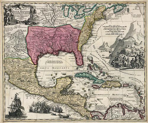
Regni Mexicani seu Novae Hispaniae Ludovicianae, N. Anglia, Carolinae, Virginiae et Pensylvaniae nec non Insularum Archipelagi Mexicani in America Septentrionali.
By Johann Baptist Homann, Nuremburg. c.1720
Copper plate engraving.
Image size 18 3/4 x 22 3/8" (47.5 x 56.8 cm).
This highly decorative map was based on Delisle's cartographically important map of 1703. Delisle's map was the first to incorporate accurately the information from La Salle, Bienville, d'Iberville and other French explorers as to the placement and course of the Mississippi River. It was also the first map to accurately portray the mouth of the Mississippi and the Great Lakes region. Nicely embellished with scenes that include an unidentified naval battle and gold mining. The routes of the gold and merchant fleets from Central and South America are shown. Homann was a German engraver and publisher who established himself and his family in Nuremberg in 1702. He published his first atlas, "Atlas Novus," in 1707, and in recognition of this achievement, he was elected to the Berlin Academy of Sciences. In 1715 Homann was appointed Geographer to the Emperor. Homann died in 1724 and his business was continued by his family under the name Homann's Heirs into the late 18th century.
Cumming, "Southeast in Early Maps" #137 (Delisle).Good condition. Original hand coloring.Condition
- Shipping Info
-
The Old Print Ship, Inc.
150 Lexington Avenue
New York, NY 10016
-
- Buyer's Premium


 EUR
EUR CAD
CAD AUD
AUD GBP
GBP MXN
MXN HKD
HKD CNY
CNY MYR
MYR SEK
SEK SGD
SGD CHF
CHF THB
THB


