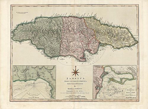
Finely engraved map of Jamaica
About Seller
150 Lexington Avenue
New York, NY 10016
United States
The Old Print Shop, Inc. was founded in New York City in 1988. Specialist art gallery in American art including painting, drawing and printmaking from 1700 to contemporary, antique maps and atlases, artist's books and reference books. Our staff and owners are experts in American art, assist in colle...Read more
About Auction
Jun 5, 2017 - Jun 19, 2017
The Old Print Shop, Inc info@oldprintshop.com
- Lot Description
Jamaica from The Latest Surveys.
By Thomas Jefferys, London. 1775-1794.
Copper plate engraving.
Image 18 3/8 x 24 1/4” (46.2 x 61.6 cm).
This is a beautiful and finely engraved map of the island of Jamaica that first appeared in Thomas Jeffreys' "The West Indian Atlas," a detailed description of the West Indies including charts and historical accounts based on surveys conducted during that time. This map includes names of towns and geographic landmarks, and shows anchorages, soundings along the coast, rivers, and roads. The upper left corner includes the annotation "The Negro-towns are Distinguished by a Stroke under the Name.” Insets in the lower left and right corners show the Harbor of Bluefields and the Harbors of Kingston and Port Royal, depicted in detail including coastal soundings and the names of some plantations.Condition
Good condition. Original hand coloring.
- Shipping Info
-
The Old Print Ship, Inc.
150 Lexington Avenue
New York, NY 10016
-
- Buyer's Premium


 EUR
EUR CAD
CAD AUD
AUD GBP
GBP MXN
MXN HKD
HKD CNY
CNY MYR
MYR SEK
SEK SGD
SGD CHF
CHF THB
THB


