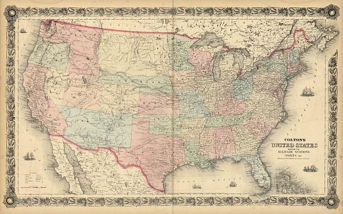
Civil War Military Station Map of the United States
About Seller
150 Lexington Avenue
New York, NY 10016
United States
The Old Print Shop, Inc. was founded in New York City in 1988. Specialist art gallery in American art including painting, drawing and printmaking from 1700 to contemporary, antique maps and atlases, artist's books and reference books. Our staff and owners are experts in American art, assist in colle...Read more
About Auction
Jun 5, 2017 - Jun 19, 2017
The Old Print Shop, Inc info@oldprintshop.com
- Lot Description
Colton's United States shewing the military stations, Forts &c.
By J. H. Colton, New York. c.1861-62. Printed by Lang & Laing, Lith. 117 Fulton St. N.Y.
Stone engraving.
Image 14 x 24 1/2" (35.6 x 62.3 cm) plus decorative border and margins.
This map appeared in a c.1862 Colton's "General Atlas" as a possible replacement for their earlier map of the United States first issued in 1855. The title notes that it shows the military stations and forts which are delineated with a small flag. The Library of Congress shows an example of this map with a date of 1861 and the flags colored. There are also other small differences within the map itself, forts moved, a dotted line between Denver City, Pike's Peak and Salt Lake City. During the war the demand for maps by the public was almost insatiable. The publishers rushed to fill the demand but many of the maps were outdated almost as soon are they were issued. Many of the maps issued often came in many states or variant editions as the publishers rushed to keep them up to date. This map did not have a long issue life and is considered to be unusual and rare.
LC "Civil War Maps" 7.Condition
Good condition save for a short tear and splitting in the lower centerfold and a faint vertical stain along the centerfold. Original hand coloring.
- Shipping Info
-
The Old Print Ship, Inc.
150 Lexington Avenue
New York, NY 10016
-
- Buyer's Premium


 EUR
EUR CAD
CAD AUD
AUD GBP
GBP MXN
MXN HKD
HKD CNY
CNY MYR
MYR SEK
SEK SGD
SGD CHF
CHF THB
THB


