Civil War Military Map of the United States
Lot 12
About Seller
The Old Print Shop, Inc
150 Lexington Avenue
New York, NY 10016
United States
The Old Print Shop, Inc. was founded in New York City in 1988. Specialist art gallery in American art including painting, drawing and printmaking from 1700 to contemporary, antique maps and atlases, artist's books and reference books. Our staff and owners are experts in American art, assist in colle...Read more
Categories
About Auction
By The Old Print Shop, Inc
Jun 5, 2017 - Jun 19, 2017
Set Reminder
2017-06-05 08:00:00
2017-06-19 20:30:00
America/New_York
Bidsquare
Bidsquare : Cartographic wonders
https://www.bidsquare.com/auctions/old-print-shop/cartographic-wonders-2417
The Old Print Shop, Inc info@oldprintshop.com
The Old Print Shop, Inc info@oldprintshop.com
- Lot Description
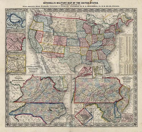
Mitchell's Military Map of the United States, showing forts, &c. With separate maps of states, vicinities of cities &c.
By S. Augustus Mitchell, Philadelphia. 1861.
Stone engraving.
Image 22 3/4 x 25 1/4" (64.1 x 57.8 cm) plus margins.
A scarce separately issued broadside map produced at the beginning of the American Civil War. This map shows the new territories that were made after southern states seceded. As the trans-Mississippi region developed during the 1850s, there was a call to break up the very large territories into smaller ones. However, every newly created territory had an impact on the power struggle in Congress over the issue of slavery, so between 1854, with its Kansas-Nebraska Act, and 1860, no new territories were created. After secession, the northerners in Congress were able to act quickly and create three new territories: a large Dakota Territory, Territory of Nevada, and Colorado Territory- all present on this map. Another feature of this map is the depiction of a never-existent horizontal border between the free territory of New Mexico and slave territory of Arizona. On August 1 1861, the Confederacy established Arizona Territory, consisting of the southern half of the Union's New Mexico Territory; the Union still claimed the whole territory. The region was sometimes called Arizona before 1863, despite the fact it was still part of the Territory of New Mexico until 1912. Two large inset maps show County map of Virginia, and North Carolina and County map of Pennsylvania, New Jersey, Maryland, and Delaware. Smaller inset maps show Hampton Roads, Washington, D.C., Pensacola Bay, Charleston Harbor, New Orleans, Louisiana, Baltimore and Richmond.
LC "Civil War Maps" 14.6Good condition save for several short tears along sheet edges and fold lines. Small stain in upper title. Backed on ricepaper.Condition
- Shipping Info
-
The Old Print Ship, Inc.
150 Lexington Avenue
New York, NY 10016
-
- Buyer's Premium


 EUR
EUR CAD
CAD AUD
AUD GBP
GBP MXN
MXN HKD
HKD CNY
CNY MYR
MYR SEK
SEK SGD
SGD CHF
CHF THB
THB


