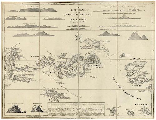
Beautiful segmented early map of the Virgin Islands
Lot 24
About Seller
The Old Print Shop, Inc
150 Lexington Avenue
New York, NY 10016
United States
The Old Print Shop, Inc. was founded in New York City in 1988. Specialist art gallery in American art including painting, drawing and printmaking from 1700 to contemporary, antique maps and atlases, artist's books and reference books. Our staff and owners are experts in American art, assist in colle...Read more
Categories
About Auction
By The Old Print Shop, Inc
Jun 5, 2017 - Jun 19, 2017
Set Reminder
2017-06-05 08:00:00
2017-06-19 20:30:00
America/New_York
Bidsquare
Bidsquare : Cartographic wonders
https://www.bidsquare.com/auctions/old-print-shop/cartographic-wonders-2417
The Old Print Shop, Inc info@oldprintshop.com
The Old Print Shop, Inc info@oldprintshop.com
- Lot Description
The Virgin Islands from English and Danish Surveys.
By Thomas Jefferys, London. 1775. (1794).
Copper plate engraving.
Image 18 1/4 x24 1/8” (46.2 x 61.4 cm).
This is a finely engraved and highly sought-after map of the Virgin Islands from Thomas Jefferys' "The West Indian Atlas". This particular chart was first issued by Jefferys in 1775, as one of the first separately issued maps of the Virgin Islands and the earliest obtainable large format map of the region. It shows landmark names, anchorages, shoals, soundings, and bays, and also includes geographical and historical commentary on areas of the islands, as well as an inset note entitled “Observations”. Some of the islands shown are St. Thomas, St. Johns, Tortola, Virgin Gorda or Spanish Town, Anguilla, St. Martins, St Christophers, St. Eustatia, Saba and St. Croix, as well as the eastern end of Puerto Rico. This is a beautiful chart in a segmented case map version. The map was separately issued, and cut into 16 equal square sections which were joined on cloth, so that the segmented map could be folded to make it more portable and durable for travel. Lacks slip case.Good condition. Black & White.Condition
- Shipping Info
-
The Old Print Ship, Inc.
150 Lexington Avenue
New York, NY 10016
-
- Buyer's Premium


 EUR
EUR CAD
CAD AUD
AUD GBP
GBP MXN
MXN HKD
HKD CNY
CNY MYR
MYR SEK
SEK SGD
SGD CHF
CHF THB
THB


