A rare chart of the Caribbean
Lot 17
About Seller
The Old Print Shop, Inc
150 Lexington Avenue
New York, NY 10016
United States
The Old Print Shop, Inc. was founded in New York City in 1988. Specialist art gallery in American art including painting, drawing and printmaking from 1700 to contemporary, antique maps and atlases, artist's books and reference books. Our staff and owners are experts in American art, assist in colle...Read more
Categories
About Auction
By The Old Print Shop, Inc
Jun 5, 2017 - Jun 19, 2017
Set Reminder
2017-06-05 08:00:00
2017-06-19 20:30:00
America/New_York
Bidsquare
Bidsquare : Cartographic wonders
https://www.bidsquare.com/auctions/old-print-shop/cartographic-wonders-2417
The Old Print Shop, Inc info@oldprintshop.com
The Old Print Shop, Inc info@oldprintshop.com
- Lot Description
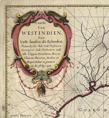
Caarte Van West Indien, Soo Vaste landen als Eylanden... .
By Joan Vingboons. Published in Amsterdam by Gerard Valk and Peter Schenk. Amsterdam. c.1655 – c.1700.
Copper plate engraving.
Image 19 7/8 x 28 1/8" (50.5 x 71.4 cm) plus margins.
Highly important engraved chart of the southeast coast of North America and the Caribbean, based on the most recent surveys of the Dutch West India Company. Directly associated with the manuscript and printed work of Hessel Gerritz, c. 1628-30. The Gerritz and Vingboons charts, and their original cartography, were the earliest challenges to the authority of the great Blaeu West Indische Pascaert which drew on slightly earlier material. The more advanced cartography of Gerritz and Vingboons soon dominated Dutch chart-making, and by 1660 replaced the work of Blaeu to become the foundation for many other charts of America including ones by Colom, Donker, Van Loon, Goos, Roggeveen and Van Keulen. Hessel Gerritz was for many years the official cartographer to the Dutch East India Company, and is known to have sailed on a voyage to the West Indies and South America in 1628. His early work is of very high quality, including his large DE EYLANDEN...VAN WESTINDIEN, c.1631 - the very first important break with the Blaeu Pascaert, and drawing on the same Dutch manuscripts as did Vingboons. Joan Vingboons is best known as the assumed author of the famous Manatus manuscript map of New York, now in the Library of Congress, and like Gerritz had good access to the manuscripts of the Dutch West India Company. Among his other surviving manuscripts is the original draft for his large WEST INDIEN chart offered for sale here. The manuscript version was once owned by Henry Harrise and is now in the collections of the Library of Congress. The Vingboons chart thus takes its place as one of the earliest and most influential Dutch charts of America - based on new and highly influential surveys accumulated by the Dutch West India Company. It is further distinguished by the addition of much inland information, from the Mississippi River to the wealth of place names and topographical detail in and around the Chesapeake Bay (the Delaware Bay is now shown) These details are not found on any earlier printed chart. The date is conjectural - Burden chooses c. 1655, Lowrey (who did not know of the printed version) cites the manuscript and with a date of 1639. Beautifully designed and engraved it is certainly one of the finest Dutch charts of America ever produced. The Vingboons chart is rare. No copy of the first state of the chart is known to exist. Koeman lists no copy of any state.
Burden, P. "North America" #314 (#236 Gerritz); Harrisse. Discovery of North America, p. 612.Overall in good condition. Backed on linen. There is some running of the red pigment, which likely occurred when the linen was applied. There is some loss of paper due to verdigris in the western edge of Virginia. One split in the top which parallels a fold line. We believe the coloring to be period.Condition
- Shipping Info
-
The Old Print Ship, Inc.
150 Lexington Avenue
New York, NY 10016
-
- Buyer's Premium


 EUR
EUR CAD
CAD AUD
AUD GBP
GBP MXN
MXN HKD
HKD CNY
CNY MYR
MYR SEK
SEK SGD
SGD CHF
CHF THB
THB


