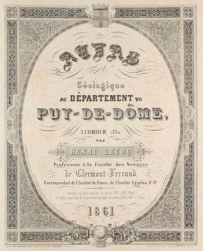
Henri Lecoq Atlas géologique du département du Puy-de-Dôme par Henri Lecoq, professeur à la Faculté des sciences de Clermont-Ferrand, correspondant de
Two ways to bid:
- Leave a max absentee bid and the platform will bid on your behalf up to your maximum bid during the live auction.
- Bid live during the auction and your bids will be submitted real-time to the auctioneer.
Bid Increments
| Price | Bid Increment |
|---|---|
| EUR€0 | EUR€10 |
| EUR€100 | EUR€10 |
| EUR€200 | EUR€20 |
| EUR€300 | EUR€30 |
| EUR€420 | EUR€30 |
| EUR€480 | EUR€20 |
| EUR€500 | EUR€50 |
| EUR€2,000 | EUR€200 |
| EUR€3,200 | EUR€300 |
About Auction
Dec 14, 2021
Jeschke Jádi Auctions Berlin GmbH info@jvv-berlin.de
- Lot Description
Geologie
Lecoq, Henri
Atlas géologique du département du Puy-de-Dôme par Henri Lecoq, professeur à la Faculté des sciences de Clermont-Ferrand, correspondant de l'Institut de France, de l'Institut égyptien etc. etc. Exécuté à ses frais pendant les années 1827 à 1858 (31 ans) et publiée aux frais du département pendant les années 1859 à 1861 (3 ans).- Clermont-Ferrand, Imprimerie lithographique Paris-Beaulieu, imprimé en noir et en couleur par Gilberton, 1861. Mit einem lithographischen Titelblatt, 23 chromolithographischen Karten und 1 chromolithographischen Legende. 25 Bll. Imperial-Folio. (ca. 78x55 cm) Hldr. d. Zt. mit montierten Deckelschild (berieben, bestoßen und beschabt).
Jahrbuch für Mineralogie, Geologie und Paläontologie (1862), 472. - Sehr selten, kein Exemplar im internationalen Handel nachweisbar, kein Exemplar auf Auktionen. Bedeutender und wichtiger geologischer Atlas der Region Puy-de-Dôme. Es liegt in der Mitte des Landes in der Region Auvergne-Rhône-Alpes und ist nach dem Vulkan Puy de Dôme im Zentralmassiv benannt. Der 1465 Meter hohe Vulkan ist der höchste Berg der Chaîne des Puys, der Kette der Puys. Südwestlich der Chaîne des Puys liegt die Gruppe der ebenfalls ruhenden Vulkane der Monts Dore. Der Vulkan besteht aus zwei Lavadomen aus Trachyt, die sich vor 11.000 bis 10.000 Jahren nacheinander über alte Schlackenkegel herausgeschoben haben. An den Flanken finden sich Brekzien und Ablagerungen von Glutwolken (Ignimbrit) vom Kollaps des ersten Doms. Weite Teile sind auch von Tephra des benachbarten Kilian-Kraters überdeckt, der vor 8550 Jahren kollabiert war. Er zählt zu den monogenetischen Vulkanen. Prachtvoll chromolithographierter Atlas des großen französischen Naturwissenschaftlers Lecoq der das Departement in seinen geologischen Formationen aufmerksam exploriert. Die Titelseite als Tafel 6 wie im Exemplar der Bibliothèque de Mines der Universität ParisTech, hier aber zu Beginn eingebunden. Teils vor allem am Rand etwas braun- oder wasserfleckig. Die Karten alt auf Leinen kaschiert von prächtiger Farbigkeit. - Sehr selten.
Geology. - With a lithographic title page, 23 chromolithographic maps and 1 chromolithographic legend. Contemporary half calf (partly rubbed, bumped and chafed). - Very rare, no copy traceable in international trade, no copy at auction. Important and significant geological atlas of the Puy-de-Dôme region. It is located in the centre of the country in the Auvergne-Rhône-Alpes region and is named after the Puy de Dôme volcano in the Massif Central. The 1465-metre high volcano is the highest mountain in the Chaîne des Puys, the chain of the Puys. Southwest of the Chaîne des Puys is the group of Monts Dore volcanoes, which are also dormant. The volcano consists of two lava domes made of trachyte, which were pushed out one after the other over old cinder cones 11,000 to 10,000 years ago. On the flanks are breccias and deposits of ignimbrite from the collapse of the first dome. Large parts are also covered by tephra from the neighbouring Kilian crater, which collapsed 8550 years ago. It belongs to the monogenetic volcanoes. Magnificently chromolithographed atlas by the great French naturalist Lecoq, who carefully explores the geological formations of the department. The title page as plate 6 as in the copy of the Bibliothèque de Mines of the University of ParisTech, but here bound in at the beginning. Partly a little bit brown- or waterstained especially at the margins. The maps old mounted on linen of splendid colours. - Very rare. *
- Buyer's Premium


 EUR
EUR CAD
CAD AUD
AUD GBP
GBP MXN
MXN HKD
HKD CNY
CNY MYR
MYR SEK
SEK SGD
SGD CHF
CHF THB
THB


