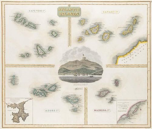
Atlantic Islands. Drawn & Engraved for Thomsons New General Atlas. 4 kol. Kupferstichkarten von T. Clerk auf 1 Blatt. Edinbur
Lot 593
Categories
Estimate:
$120 - $240
Absentee vs Live bid
Two ways to bid:
- Leave a max absentee bid and the platform will bid on your behalf up to your maximum bid during the live auction.
- Bid live during the auction and your bids will be submitted real-time to the auctioneer.
Bid Increments
| Price | Bid Increment |
|---|---|
| $0 | $10 |
| $100 | $10 |
| $200 | $20 |
| $300 | $30 |
| $420 | $30 |
| $480 | $20 |
| $500 | $50 |
| $2,000 | $200 |
| $3,200 | $300 |
About Auction
By Jeschke Jádi Auctions Berlin GmbH
Dec 9, 2016 - Dec 10, 2016
Set Reminder
2016-12-09 06:00:00
2016-12-10 06:00:00
America/New_York
Bidsquare
Bidsquare : Rare Books Decorative Prints Historical Photography
https://www.bidsquare.com/auctions/jeschke-van-vliet/rare-books-decorative-prints-historical-photography-1998
Jeschke Jádi Auctions Berlin GmbH info@jvv-berlin.de
Jeschke Jádi Auctions Berlin GmbH info@jvv-berlin.de
- Lot Description
Atlantic Islands. Drawn & Engraved for Thomsons New General Atlas. 4 kol. Kupferstichkarten von T. Clerk auf 1 Blatt. Edinburgh, 1814. Ca. 50 x 59 cm (53 x 65,5 cm). Broekema: Maps of the Canary Island Nr. 130. - Im Zentrum mit Ansicht des Pico del Teide in Teneriffa, umgeben von 4 Karten: Capverdische und Kanarische Insekn, Azoren und Madeira (mit kl. Insetkarten von Fayal und Lanzarote). - Mittelfalz, minimal gebraeunt.
- Buyer's Premium


 EUR
EUR CAD
CAD AUD
AUD GBP
GBP MXN
MXN HKD
HKD CNY
CNY MYR
MYR SEK
SEK SGD
SGD CHF
CHF THB
THB


