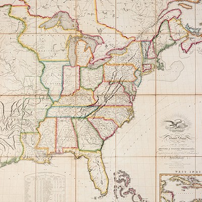
* TANNER, Henry Schenck. A New American Atlas containing Maps of the Several States of the North American Union. Phila.: [1818-]
Lot 113
About Seller
Hindman
1338 West Lake Street
Chicago, IL 60607
United States
Recognized as the Midwest's leading fine art auctioneers, Hindman Auctioneers has built a worldwide reputation based on a full service approach to the auction business tailored to meet the individual needs of our clients. Coming from a variety of educational backgrounds, specialists bring years of e...Read more
Categories
Estimate:
$10,000 - $15,000
Absentee vs Live bid
Two ways to bid:
- Leave a max absentee bid and the platform will bid on your behalf up to your maximum bid during the live auction.
- Bid live during the auction and your bids will be submitted real-time to the auctioneer.
Bid Increments
| Price | Bid Increment |
|---|---|
| $0 | $25 |
| $500 | $50 |
| $1,000 | $100 |
| $2,000 | $250 |
| $5,000 | $500 |
| $10,000 | $1,000 |
| $20,000 | $2,500 |
| $50,000 | $5,000 |
| $100,000 | $10,000 |
About Auction
By Hindman
Nov 12, 2018
Set Reminder
2018-11-12 11:00:00
2018-11-12 11:00:00
America/New_York
Bidsquare
Bidsquare : The Fine Cartographic and Printed Americana Collection of Evelyn and Eric Newman
https://www.bidsquare.com/auctions/hindman-auctions/the-fine-cartographic-and-printed-americana-collection-of-evelyn-and-eric-newman-3534
Hindman Bidsquare@hindmanauctions.com
Hindman Bidsquare@hindmanauctions.com
- Lot Description
* TANNER, Henry Schenck (1786-1858). A New American Atlas containing Maps of the Several States of the North American Union. Philadelphia: By the Author, [1818-]1823.
Folio (582 x 404 mm). 18 engraved double-page maps with hand-coloring on 22 sheets (South America on two sheets, North America on 4 sheets); half-title, engraved vignette title showing the first landing of Columbus in the New World, 1p. index, 18pp. "Geographical Memoir," 2pp. "To the Public" notice dated Jan. 1 1821, 1p. advertisement "New and Elegant American Atlas, now Publishing by Tanner, Vallance, Kearny and Co., engravers, Philadelphia" dated July 10 1818. (Some marginal chipping or brittle margins, primarily to preliminary leaves, a few maps with short tears along folds or in margins, some browning or staining.) Contemporary half calf, marbled boards (covers detached, spine broken, worn).
FIRST EDITION, BOUND FROM THE ORIGINAL PARTS
"A landmark in American cartography ... the first comprehensive analytical compilation of existing cartographic and geographic data for the United States as a whole" (Schwartz & Ehrenberg). Maps dated 1818-1823, map of South America entitled South America and West Indies. 1818, with the letterpress announcement dated July 10th 1818 and the letterpress notice dated January 1st 1821, the maps of the World, Europe, South America, New York, Ohio and Indiana, America, and Asia (comprising parts I and II) with the imprint "Tanner, Vallance, Kearny and co. engravers, Philadelphia." Tanner's 1822 map of North America, produced for his atlas, was "a landmark -- a great cartographical achievement" (Wheat). See Howes T29; Phillips 463; Rumsey 2589; Sabin 94321; Schwartz & Ehrenberg p.251; Wheat Transmississippi 350.
Estimate $10,000-15,000
Provenance: Acquired from Swann Galleries, sale 692, lot 29, 20 January 1966.
- Shipping Info
-
Please refer to https://www.lesliehindman.com/shipping-packing/
-
- Buyer's Premium


 EUR
EUR CAD
CAD AUD
AUD GBP
GBP MXN
MXN HKD
HKD CNY
CNY MYR
MYR SEK
SEK SGD
SGD CHF
CHF THB
THB![* TANNER, Henry Schenck. A New American Atlas containing Maps of the Several States of the North American Union. Phila.: [1818-]](https://s1.img.bidsquare.com/item/l/3925/3925399.jpeg?t=1GalnL)
![* TANNER, Henry Schenck. A New American Atlas containing Maps of the Several States of the North American Union. Phila.: [1818-]](https://s1.img.bidsquare.com/item/s/3925/3925399.jpeg?t=1GalnL)


