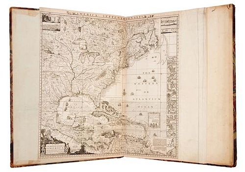
* POPPLE, Henry. A Map of the British Empire in America with the French and Spanish settlements adjacent thereto. London, 1733 [
Lot 101
About Seller
Hindman
1338 West Lake Street
Chicago, IL 60607
United States
Recognized as the Midwest's leading fine art auctioneers, Hindman Auctioneers has built a worldwide reputation based on a full service approach to the auction business tailored to meet the individual needs of our clients. Coming from a variety of educational backgrounds, specialists bring years of e...Read more
Categories
Estimate:
$30,000 - $40,000
Absentee vs Live bid
Two ways to bid:
- Leave a max absentee bid and the platform will bid on your behalf up to your maximum bid during the live auction.
- Bid live during the auction and your bids will be submitted real-time to the auctioneer.
Bid Increments
| Price | Bid Increment |
|---|---|
| $0 | $25 |
| $500 | $50 |
| $1,000 | $100 |
| $2,000 | $250 |
| $5,000 | $500 |
| $10,000 | $1,000 |
| $20,000 | $2,500 |
| $50,000 | $5,000 |
| $100,000 | $10,000 |
About Auction
By Hindman
Nov 12, 2018
Set Reminder
2018-11-12 11:00:00
2018-11-12 11:00:00
America/New_York
Bidsquare
Bidsquare : The Fine Cartographic and Printed Americana Collection of Evelyn and Eric Newman
https://www.bidsquare.com/auctions/hindman-auctions/the-fine-cartographic-and-printed-americana-collection-of-evelyn-and-eric-newman-3534
Hindman Bidsquare@hindmanauctions.com
Hindman Bidsquare@hindmanauctions.com
- Lot Description
* POPPLE, Henry (d.1743). A Map of the British Empire in America with the French and Spanish settlements adjacent thereto. London: William Henry Toms, 1733 [but c.1735].
Folio (528 x 358 mm). Double-page key map by Toms (sheet 527 x 512mm), 20 engraved sheets (15 double-page and 5 single-page), and letterpress contents leaf, all mounted on guards. (Key map laid down and shaved slightly along lower margin, sheet 1 with slight marginal wormtrack on upper margin, sheet 17 with 1 1/2-in. closed marginal tear repaired with tissue, some very minor spotting and pale offsetting, minor occasional soiling.) Contemporary half calf, marbled boards (spine perished, upper cover detached, lower cover nearly detached, corners worn, hinges reinforced with cloth tape).
A FINE COPY OF THE FIRST LARGE-SCALE PRINTED MAP OF COLONIAL NORTH AMERICA, THE FIRST PRINTED MAP TO SHOW THE THIRTEEN COLONIES AND A MONUMENT OF NORTH AMERICAN CARTOGRAPHY
Babinski's state 5 or 6: with no imprint on title sheet 17, imprint on sheet 20 reading "London Engrav'd by Willm. Henry Toms 1733" (without R. W. Seale's name), sheet 1 with the engraved numeral "1" in the upper left corner just outside neatlines and with engraved sheet number added to upper right corners of each sheet. The key map is present in the Babinski's 4th state [c.1740], with the addition of a dotted line from Vera Crux to Havana among the ships in the Gulf of Mexico with text along the line. This copy also contains the first state of the letterpress Contents leaf entitled "The Contents of each Sheet of the Twenty Plates of Mr. Popple's Map of America," with incorrect enumeration of sheet 13 as XII (Babinski State 1). See Babinski, Henry Popple's 1733 Map; Lowery 337 (key map) & 338; Sabin 64140; Howes P-481; McCorkle, America Emergent 21; Schwartz & Ehrenberg, p. 151.
Estimate $30,000-40,000
Provenance: Early Ms plate numbers in upper right corners on versos of double sheets, rectos of single sheets (mostly cropped or trimmed).
- Shipping Info
-
Please refer to https://www.lesliehindman.com/shipping-packing/
-
- Buyer's Premium


 EUR
EUR CAD
CAD AUD
AUD GBP
GBP MXN
MXN HKD
HKD CNY
CNY MYR
MYR SEK
SEK SGD
SGD CHF
CHF THB
THB


