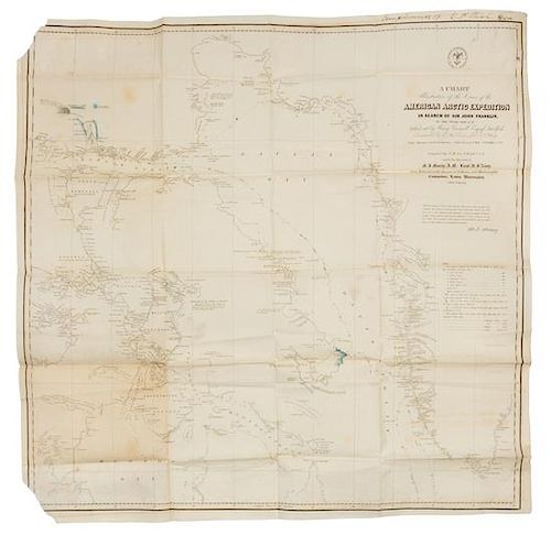
* MAURY, Matthew Fontaine. A Chart...of the Cruise of the American Arctic Expedition in search of Sir John Franklin. Wash., D.C.
Lot 82
About Seller
Hindman
1338 West Lake Street
Chicago, IL 60607
United States
Recognized as the Midwest's leading fine art auctioneers, Hindman Auctioneers has built a worldwide reputation based on a full service approach to the auction business tailored to meet the individual needs of our clients. Coming from a variety of educational backgrounds, specialists bring years of e...Read more
Categories
Estimate:
$2,000 - $3,000
Absentee vs Live bid
Two ways to bid:
- Leave a max absentee bid and the platform will bid on your behalf up to your maximum bid during the live auction.
- Bid live during the auction and your bids will be submitted real-time to the auctioneer.
Bid Increments
| Price | Bid Increment |
|---|---|
| $0 | $25 |
| $500 | $50 |
| $1,000 | $100 |
| $2,000 | $250 |
| $5,000 | $500 |
| $10,000 | $1,000 |
| $20,000 | $2,500 |
| $50,000 | $5,000 |
| $100,000 | $10,000 |
About Auction
By Hindman
Nov 12, 2018
Set Reminder
2018-11-12 11:00:00
2018-11-12 11:00:00
America/New_York
Bidsquare
Bidsquare : The Fine Cartographic and Printed Americana Collection of Evelyn and Eric Newman
https://www.bidsquare.com/auctions/hindman-auctions/the-fine-cartographic-and-printed-americana-collection-of-evelyn-and-eric-newman-3534
Hindman Bidsquare@hindmanauctions.com
Hindman Bidsquare@hindmanauctions.com
- Lot Description
* MAURY, Matthew Fontaine (1806-1873). A Chart Illustrative of the Cruise of the American Arctic Expedition in search of Sir John Franklin. In the Years 1850 & 51. [Washington, D. C.: United States Hydrographical Office, ca 1851].
Engraved chart with hand-coloring in outline printed on thin paper of the First Grinnell Expedition, the first American attempt to find Franklin's lost Polar expedition, 616 x 622 mm image (637 x 640 mm sheet). (Tears with loss to left corners, creased.)
FIRST EDITION, FIRST STATE, INSCRIBED BY WELSH, the chart's compiler, in the margin: "Compliments of G. P. Welsh." A second state, on thick paper by Disturnell & Schroeter in New York, was issued with a label pasted over the names of the engravers of the first issue, Sherman & Smith. This rare chart of the First Grinnell Expedition was constructed by Maury; Welsh compiled it, showing the path the American vessels took along Greenland, across Baffin bay, and up the Wellington Channel. Areas shaded blue indicate new geographic discoveries from that expedition. Franklin's Polar expedition set out on 19 May 1845 in Terror and Erebus; they were sighted by a whaling vessel off Baffin Island on 26 July 1845, and were never seen again. The first search party was dispatched in 1847. American merchant Henry Grinnell financed this first American effort to locate Franklin and his party. VERY UNCOMMON: Rare Book Hub traces only one sale of this Arctic rarity in over one hundred years: the Edward Everett Hale copy, sold Merwin-Clayton Sales Company New York, sale 408, lot 36, 19 June 1911; WorldCat locates 7 copies in institutions.
Estimate $2,000-3,000 - Shipping Info
-
Please refer to https://www.lesliehindman.com/shipping-packing/
-
- Buyer's Premium


 EUR
EUR CAD
CAD AUD
AUD GBP
GBP MXN
MXN HKD
HKD CNY
CNY MYR
MYR SEK
SEK SGD
SGD CHF
CHF THB
THB


