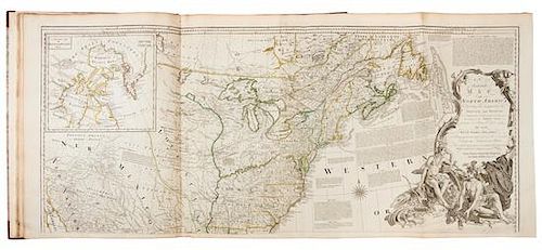
* JEFFERYS, Thomas (ca 1719-1771). The American Atlas. London R. Sayer and J. Bennett, 1776.
Lot 69
About Seller
Hindman
1338 West Lake Street
Chicago, IL 60607
United States
Recognized as the Midwest's leading fine art auctioneers, Hindman Auctioneers has built a worldwide reputation based on a full service approach to the auction business tailored to meet the individual needs of our clients. Coming from a variety of educational backgrounds, specialists bring years of e...Read more
Categories
Estimate:
$60,000 - $80,000
Absentee vs Live bid
Two ways to bid:
- Leave a max absentee bid and the platform will bid on your behalf up to your maximum bid during the live auction.
- Bid live during the auction and your bids will be submitted real-time to the auctioneer.
Bid Increments
| Price | Bid Increment |
|---|---|
| $0 | $25 |
| $500 | $50 |
| $1,000 | $100 |
| $2,000 | $250 |
| $5,000 | $500 |
| $10,000 | $1,000 |
| $20,000 | $2,500 |
| $50,000 | $5,000 |
| $100,000 | $10,000 |
About Auction
By Hindman
Nov 12, 2018
Set Reminder
2018-11-12 11:00:00
2018-11-12 11:00:00
America/New_York
Bidsquare
Bidsquare : The Fine Cartographic and Printed Americana Collection of Evelyn and Eric Newman
https://www.bidsquare.com/auctions/hindman-auctions/the-fine-cartographic-and-printed-americana-collection-of-evelyn-and-eric-newman-3534
Hindman Bidsquare@hindmanauctions.com
Hindman Bidsquare@hindmanauctions.com
- Lot Description
* JEFFERYS, Thomas (ca 1719-1771). The American Atlas: or, a geographical description of the whole continent of America. London R. Sayer and J. Bennett, 1776.
Folio (562 x 411 mm). Letterpress Index leaf (listing 30 maps), 23 maps on 30 sheets (most double-page or folding), hand-colored in outline, all mounted on guards. (Sheet 17 a little darkened and frayed at margins with two short marginal tears; sheet 23 with tear repaired crossing neatline in upper right corner; sheet 24 with right fore-margin a little darkened and frayed; some very minor occasional marginal soiling or finger-soiling.) Later half calf, marbled boards (covers detached, later endpapers).
THE MOST IMPORTANT 18TH CENTURY ATLAS FOR AMERICA: a "geographical description of the whole continent of America, as portrayed in the best available maps in the latter half of the eighteenth century ... as a major cartographic reference work it was, very likely, consulted by American, English, and French civilian administrators and military officers during the Revolution" (Ristow).
The American Atlas has several editions dated 1776. This copy with the second title-page mentioning 49 plates and with Holland's name listed as major, and the letterpress index listing 30 maps (the first index lists 29 maps). There are various combinations of maps included in the several 1776 editions which were made up. Each map has an ink-numbered stamp on the upper righthand verso. Bowen & Gibson's "An Accurate Map of North America," numbered 5-6, is an earlier issue, with imprint dated July 2, 1775 (Stevens & Tree 49d). Map 8, British North America, was originally dated 1775 and was revised here to Aug. 17, 1776. The New York and New Jersey map (map 17) was likewise originally dated 1775 and now revised to Aug. 17, 1776 (when its number was changed from 18 to 17 ). The map of Lake Champlain was not included in the 1775 edition, but is present here as number 18 in its first state. Scull's map of Pennsylvania was previously numbered 17, but is here number 20. The present edition includes A new Map of the Province of Quebec (a significant addition) in place of Jefferys' map of the Middle British Colonies. Howes J-81; see Phillips Atlases 1166; Sabin 35953; see Streeter I:72 (1775 edition); see Walter Ristow (editor), Thomas Jefferys The American Atlas London 1776, facsimile edition, Amsterdam 1974.
Estimate $60,000-80,000 - Shipping Info
-
Please refer to https://www.lesliehindman.com/shipping-packing/
-
- Buyer's Premium


 EUR
EUR CAD
CAD AUD
AUD GBP
GBP MXN
MXN HKD
HKD CNY
CNY MYR
MYR SEK
SEK SGD
SGD CHF
CHF THB
THB


