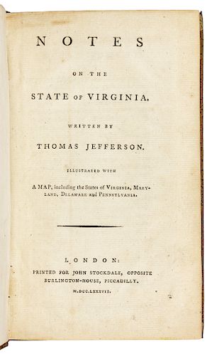
JEFFERSON, Thomas (1743-1826). Notes on the State of Virginia...Illustrated with A Map, including...Virginia, Maryland, Delaware and Pennsylvania. Lon
Lot 48
About Seller
Hindman
1338 West Lake Street
Chicago, IL 60607
United States
Recognized as the Midwest's leading fine art auctioneers, Hindman Auctioneers has built a worldwide reputation based on a full service approach to the auction business tailored to meet the individual needs of our clients. Coming from a variety of educational backgrounds, specialists bring years of e...Read more
Categories
Estimate:
$20,000 - $30,000
Absentee vs Live bid
Two ways to bid:
- Leave a max absentee bid and the platform will bid on your behalf up to your maximum bid during the live auction.
- Bid live during the auction and your bids will be submitted real-time to the auctioneer.
Bid Increments
| Price | Bid Increment |
|---|---|
| $0 | $25 |
| $500 | $50 |
| $1,000 | $100 |
| $2,000 | $250 |
| $5,000 | $500 |
| $10,000 | $1,000 |
| $20,000 | $2,500 |
| $50,000 | $5,000 |
| $100,000 | $10,000 |
About Auction
By Hindman
Nov 5, 2019
Set Reminder
2019-11-05 11:00:00
2019-11-05 11:00:00
America/New_York
Bidsquare
Bidsquare : Library of a Midwestern Collector
https://www.bidsquare.com/auctions/hindman-auctions/library-of-a-midwestern-collector-4496
Hindman Bidsquare@hindmanauctions.com
Hindman Bidsquare@hindmanauctions.com
- Lot Description
JEFFERSON, Thomas (1743-1826). Notes on the State of Virginia...Illustrated with A Map, including...Virginia, Maryland, Delaware and Pennsylvania. London: Printed for John Stockdale, 1787.
8vo (215 x 123 mm). Full-page woodcut of "Madison's cave" at C8v, several printed tables in the text, large folding table of Indian Tribes, large folding engraved map [see below]. (Slightest offsetting from binding onto title edges.) Contemporary French quarter sheep gilt, sprinkled boards, corners vellum-tipped, smooth spine gilt-decorated, russet morocco lettering-piece, pink silk ribbon marker (minor wear to spine ends, some light rubbing to joints, hinges tightened); quarter morocco folding case. Provenance: J. William Smith Collection (Syracuse Public Library bequest bookplate in honor Rev. Ezekiel Wilson Mundy, Librarian; collection dispersed in the 1990s).
FIRST LONDON EDITION, following the privately printed, virtually unobtainable first edition (Paris, 1782 [i.e., 1785]) and a poor French translation (Paris, 1786). This edition contains new accounts of events during and since the Revolution (when Jefferson served as Governor) and features the map engraved at Jefferson's request to incorporate the most up-to-date topographical data on the soon-to-be-opened Ohio Valley.
Two appendices are of considerable significance; these were issued as supplements with a few copies of the original edition, but are integral to this edition. Appendix II contains the full text of THE PROPOSED VIRGINIA CONSTITUTION, prepared by Jefferson and a committee of "revisers" in the summer of 1783. It was, Jefferson proudly declared, a legal code drafted in "the plain language of common sense" (quoted in R.B. Bernstein, Are We To Be A Nation: The Making of the Constitution, p.65). Appendix III contains THE VIRGINIA ACT FOR ESTABLISHING RELIGIOUS FREEDOM passed in 1786. This act was entirely drafted by Jefferson, who "rated it as second in importance only to the Declaration of Independence in such lists of his own achievements as he afterwards drew up" (Dumas Malone, Jefferson the Virginian, pp. 279-280). Pages 293-332 contain a bibliography of pamphlets published in Virginia relating to the controversy over taxation, plus a chronological catalogue of American state papers, largely treaties, compiled by Jefferson, certainly one of the earliest such bibliographical efforts. Church 1189 (first edition); Howes J-78; Sabin 35896; Sowerby 4, pp. 101-30. AN EXTREMELY FINE COPY.
[Bound with as issued:]
A Map of the Country Between Albemarle Sound and Lake Erie, Comprehending the Whole of Virginia, Maryland, Delaware and Pensylvania Engraved for the Notes on Virginia. London: Engraved by S. J. Neele, No.352 Strand, London, Published as the Act directs July 13th, 1787 by John Stockdale. 622 x 597 mm., hand-colored in outline (2-inch tear at gutter just crossing image at upper right, otherwise very fine).
An important post-Revolutionary map of Virginia, first issued with the 1786 French edition of the Notes, derived from Fry and Jefferson's key map of Virginia (1751, additions in 1755), Nicholas Scull's of Pennsylvania, and Thomas Hitchins' of Virginia (1778). Jefferson was quite aware of the cartographic importance of the composite map: "When Jefferson, then minister to France, decided to publish his Notes on the State of Virginia, first in a French and then in an English edition of 1787, he had the [Fry & Jefferson] map re-engraved, for the occasion, speaking of it with justifiable pride as more valuable than the book in which it was to appear" (The Eye of Thomas Jefferson, ed. W. H. Adams, p. 4). Phillips, p. 984.
For condition inquiries please contact Gretchen Hause at gretchenhause@hindmanauctions.comCondition
- Shipping Info
-
Please refer to https://hindmanauctions.com/shipping-packing
-
- Buyer's Premium


 EUR
EUR CAD
CAD AUD
AUD GBP
GBP MXN
MXN HKD
HKD CNY
CNY MYR
MYR SEK
SEK SGD
SGD CHF
CHF THB
THB


![1667 Land Deed [Massachusetts Bay Colony / Boston] on Parchment](https://s1.img.bidsquare.com/item/m/2949/29492002.jpeg?t=1TIB0e)


