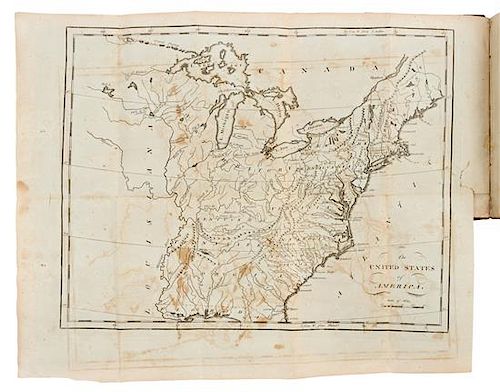
* CAREY, Matthew. Carey's American Pocket Atlas. Philadelphia: for Matthew Carey by Lang and Ustick, 1796.
Lot 42
About Seller
Hindman
1338 West Lake Street
Chicago, IL 60607
United States
Recognized as the Midwest's leading fine art auctioneers, Hindman Auctioneers has built a worldwide reputation based on a full service approach to the auction business tailored to meet the individual needs of our clients. Coming from a variety of educational backgrounds, specialists bring years of e...Read more
Categories
Estimate:
$8,000 - $12,000
Absentee vs Live bid
Two ways to bid:
- Leave a max absentee bid and the platform will bid on your behalf up to your maximum bid during the live auction.
- Bid live during the auction and your bids will be submitted real-time to the auctioneer.
Bid Increments
| Price | Bid Increment |
|---|---|
| $0 | $25 |
| $500 | $50 |
| $1,000 | $100 |
| $2,000 | $250 |
| $5,000 | $500 |
| $10,000 | $1,000 |
| $20,000 | $2,500 |
| $50,000 | $5,000 |
| $100,000 | $10,000 |
About Auction
By Hindman
Nov 12, 2018
Set Reminder
2018-11-12 11:00:00
2018-11-12 11:00:00
America/New_York
Bidsquare
Bidsquare : The Fine Cartographic and Printed Americana Collection of Evelyn and Eric Newman
https://www.bidsquare.com/auctions/hindman-auctions/the-fine-cartographic-and-printed-americana-collection-of-evelyn-and-eric-newman-3534
Hindman Bidsquare@hindmanauctions.com
Hindman Bidsquare@hindmanauctions.com
- Lot Description
* CAREY, Matthew. Carey's American Pocket Atlas. Philadelphia: for Matthew Carey by Lang and Ustick, 1796.
12mo (168 x 100 mm). 19 engraved folding maps. (Map of the United States with short tear repaired and a few minor splits at folds, a few other minor splits to a few other maps, some browning or offsetting.) Contemporary calf-backed marbled boards, smooth spine gilt (joints starting, chipping to head and foot of spine with some losses, some creasing to spine, rubbed).
FIRST EDITION OF THE FIRST AMERICAN POCKET ATLAS, with maps engraved by William Barker, Joseph H. Seymour, and Amos Doolittle, including a general map of the United States, as well as maps of Vermont, New Hampshire, Maine, Massachusetts, Rhode Island, Connecticut, New York, New Jersey, Pennsylvania, Delaware, the Northwest Territory, Maryland, Virginia, Kentucky, North Carolina, Tennessee, South Carolina and Georgia. Carey reissued the work in 1801, 1805, and 1814. COMPLETE COPIES OF THIS WORK ARE RARE AT AUCTION: according to online records, only 4 complete copies have appeared on the market in the last 40 years. Evans 30161; Howes C-137; Phillips 1364; Sabin 10856.
Estimate $8,000-12,000
Provenance: William Adamson (signature dated 1797); Nimrod Owings (signatures on title-page and first leaf of Maryland section); notes on blank leaf in an early hand calculating the distance of a route to from Richmond to Charleston.
- Shipping Info
-
Please refer to https://www.lesliehindman.com/shipping-packing/
-
- Buyer's Premium


 EUR
EUR CAD
CAD AUD
AUD GBP
GBP MXN
MXN HKD
HKD CNY
CNY MYR
MYR SEK
SEK SGD
SGD CHF
CHF THB
THB


