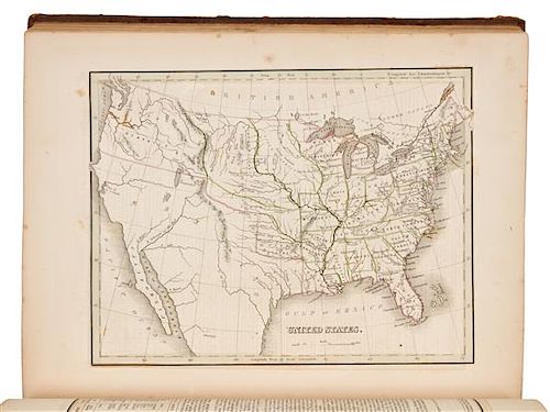
* BRADFORD, Thomas Gamaliel (1802-1887). A Comprehensive Atlas. Boston, NY and Philadelphia: William D. Ticknor and others, [183
Lot 38
About Seller
Hindman
1338 West Lake Street
Chicago, IL 60607
United States
Recognized as the Midwest's leading fine art auctioneers, Hindman Auctioneers has built a worldwide reputation based on a full service approach to the auction business tailored to meet the individual needs of our clients. Coming from a variety of educational backgrounds, specialists bring years of e...Read more
Categories
Estimate:
$800 - $1,200
Absentee vs Live bid
Two ways to bid:
- Leave a max absentee bid and the platform will bid on your behalf up to your maximum bid during the live auction.
- Bid live during the auction and your bids will be submitted real-time to the auctioneer.
Bid Increments
| Price | Bid Increment |
|---|---|
| $0 | $25 |
| $500 | $50 |
| $1,000 | $100 |
| $2,000 | $250 |
| $5,000 | $500 |
| $10,000 | $1,000 |
| $20,000 | $2,500 |
| $50,000 | $5,000 |
| $100,000 | $10,000 |
About Auction
By Hindman
Nov 12, 2018
Set Reminder
2018-11-12 11:00:00
2018-11-12 11:00:00
America/New_York
Bidsquare
Bidsquare : The Fine Cartographic and Printed Americana Collection of Evelyn and Eric Newman
https://www.bidsquare.com/auctions/hindman-auctions/the-fine-cartographic-and-printed-americana-collection-of-evelyn-and-eric-newman-3534
Hindman Bidsquare@hindmanauctions.com
Hindman Bidsquare@hindmanauctions.com
- Lot Description
* BRADFORD, Thomas Gamaliel (1802-1887). A Comprehensive Atlas Geographical, Historical & Commercial. Boston, New York, Philadelphia: William D. Ticknor, Wiley & Long, T. T. Ash, [1835].
4to (334 x 260 mm). Hand-colored engraved frontispiece, engraved title, 76 engraved maps, diagrams and plans, most with hand-coloring in outline, double column text printed within borders. (A few leaves stained, one text leaf and map of Greece with small hole at center with associated losses, scant spotting.) Original sprinkled sheep, smooth spine gilt, brown morocco lettering-piece gilt (some overall wear, some minor chipping to spine ends, hinges starting).
FIRST EDITION, FIRST ISSUE of "one of the first American general atlases to supplement the maps with lengthy geographical descriptions" (Ristow). Bradford's atlases are significant for their contribution to the cartographic history of Texas. In this issue, Texas is depicted as part of Mexico in three maps: United States; and Mexico, Guatemala, and the West Indies, showing Texas as part of the Mexican state of Tamaulipas, and showing Stephen F. Austin's Colony; and North America, which also mentions Stephen F. Austin's colony. Subsequent issues include a separate map of Texas (see lot XXX). Phillips 770; Sabin 7260; Wheat Transmississippi 408-410.
Estimate $800-1,200 - Shipping Info
-
Please refer to https://www.lesliehindman.com/shipping-packing/
-
- Buyer's Premium


 EUR
EUR CAD
CAD AUD
AUD GBP
GBP MXN
MXN HKD
HKD CNY
CNY MYR
MYR SEK
SEK SGD
SGD CHF
CHF THB
THB


