Schedel, Hartmann. Das Buch der Chroniken (atlas)
Lot 153
Categories
Estimate:
$95,000 - $110,000
Absentee vs Live bid
Two ways to bid:
- Leave a max absentee bid and the platform will bid on your behalf up to your maximum bid during the live auction.
- Bid live during the auction and your bids will be submitted real-time to the auctioneer.
Bid Increments
| Price | Bid Increment |
|---|---|
| $0 | $25 |
| $300 | $50 |
| $1,000 | $100 |
| $2,000 | $500 |
| $5,000 | $500 |
| $10,000 | $1,000 |
| $20,000 | $2,000 |
| $50,000 | $5,000 |
| $100,000 | $10,000 |
| $200,000 | $25,000 |
| $500,000 | $50,000 |
| $1,000,000 | $100,000 |
About Auction
By Guernsey's
Sep 23, 2020
Set Reminder
2020-09-23 12:00:00
2020-09-23 12:00:00
America/New_York
Bidsquare
Bidsquare : The Legendary Vladi Collection of Historical Maps
https://www.bidsquare.com/auctions/guernseys/the-legendary-vladi-collection-of-historical-maps-5507
Featuring over 300 examples of the finest quality antique maps, with proceeds benefiting MapAction, an organization that uses maps to aid those in disaster-stricken areas. Guernsey's auctions@guernseys.com
Featuring over 300 examples of the finest quality antique maps, with proceeds benefiting MapAction, an organization that uses maps to aid those in disaster-stricken areas. Guernsey's auctions@guernseys.com
- Lot Description
Schedel, Hartmann
Das Buch der Chroniken (atlas)
1493
Woodcut; uncoloured
Printed area: 76.5 x 30 cm; 30.1 x 11.8 in
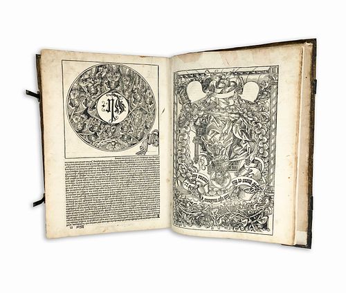
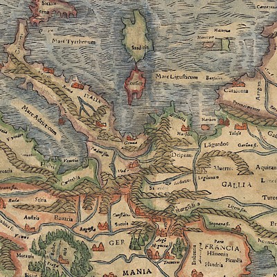
Hartmann Schedel's 'Liber chronicarum' is considered to be the most extensive illustrated printed book of the 15th century. Detailing six different ages, the Chronicle combines descriptions of famous cities with representations of historical events and references to the biblical story of salvation. The narrative follows the pattern of the universal Latin and vernacular chronicles of the Middle Ages. Parallel to the biblical story other places, events and individual town descriptions are also featured, including, for example, the founding of the city of Trier at the time of the Patriarch Abraham (3rd World Age, XXIII recto). Hartmann Schedel put a special emphasis on describing the most important cities of Germany and the occident. The collection - made up of 1804 illustrations and 652 woodblocks - serves as a fascinating document of the nascent art of printing. The map includes the first documented appearance of many cities and includes a lot of detailed information, including their founding stories, the etymology of their name and a meticulous collection of contemporary facts of culture, economy and trade. Schedel drew from a variety of different sources, including other handwritten chronicles, leaflets, medical literature, the contemporary works of the Italian and German Renaissance, other geographical and cosmographic literature and the works of Ptolemy and Strabo. The woodcut work carried out by Michael Wohlgemuths (1434/37-1519) and his stepson Wilhelm Pleydenwurff, within his Nuremberg workshop - an establishment renowned for its spectacular woodcuts, altars and sculptures and which soon emerged as a specialist in the new art of book illustration. Further mentions include references to the printer - Anton Koberger - and the German Renaissance artist, Albrecht Durer. Durer is known to have learned in the workshop between 30th November, 1486 and 1st December, 1489. The possibility of Durer's involvement in the Nuremberg Chronicle has been discussed in detail by Erwin Panofsky (1943). The dynamic brushwork and the skillful technique of some of the engravings - a marked contrast to some of the other woodcuts of the chronicle - suggest that the young Durer may have assisted with at least the preparatory drawings of some woodcuts. The idea is yet to be confirmed.
1st World Age Creation - Flood
2nd World Age Flood - The Birth of Abraham
3rd World Age The Birth of Abraham - The Beginning of the Kingdom of David
4th World Age The Beginning of the Kingdom of David - Babylonian Captivity
5th World Age Babylonian Captivity - Nativity
6th World Age Nativity - Presence (contemporary, the most extensive section)
7th World Age Coming of the Antichrist at the End of the World - View of the Last Judgement (short essay)
From the Legendary Vladi Collection of Historical Maps which includes 280 examples of the finest quality antique maps brought to auction with proceeds benefiting MapAction, an organization that uses maps and technology to aid those in disaster-stricken areas. Each map is accompanied by a certificate of authenticity issued by the consignor.
Condition: Pigskin over wooden boards, blind-stamped with portraits, seven brass cornerpieces (lacking one), and a stud on each board, with 2 fore-edge clasps (one an expert facsimile); title with old ink mss and erasures; a few minor repairs throughout the book, contemporary binding.
This item will be shipped from Hamburg, Germany. Shipping details are to be coordinated with our recommended shipper - Shipping Info
-
Guernsey's does not provide in-house packing and shipping services. Shipping, handling and insurance costs are the responsibility of the winning bidder. The majority of lots are being sold FOB Hamburg, Germany, and a lesser number of lots are being sold FOB Halifax, Canada. The description of each lot will indicate where the item is located, and from which country shipping to the successful winning bidder can be arranged. Should you wish to learn more about your shipping options, please contact Guernsey's by email at auctions@guernseys.com prior to the auction.
-
- Buyer's Premium


 EUR
EUR CAD
CAD AUD
AUD GBP
GBP MXN
MXN HKD
HKD CNY
CNY MYR
MYR SEK
SEK SGD
SGD CHF
CHF THB
THB


