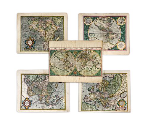
Mercator, Rumhold; Hondius, Jodocus. Important Set of Five Maps
Lot 173
Categories
Estimate:
$24,000 - $30,000
Absentee vs Live bid
Two ways to bid:
- Leave a max absentee bid and the platform will bid on your behalf up to your maximum bid during the live auction.
- Bid live during the auction and your bids will be submitted real-time to the auctioneer.
Bid Increments
| Price | Bid Increment |
|---|---|
| $0 | $25 |
| $300 | $50 |
| $1,000 | $100 |
| $2,000 | $500 |
| $5,000 | $500 |
| $10,000 | $1,000 |
| $20,000 | $2,000 |
| $50,000 | $5,000 |
| $100,000 | $10,000 |
| $200,000 | $25,000 |
| $500,000 | $50,000 |
| $1,000,000 | $100,000 |
About Auction
By Guernsey's
Sep 23, 2020
Set Reminder
2020-09-23 12:00:00
2020-09-23 12:00:00
America/New_York
Bidsquare
Bidsquare : The Legendary Vladi Collection of Historical Maps
https://www.bidsquare.com/auctions/guernseys/the-legendary-vladi-collection-of-historical-maps-5507
Featuring over 300 examples of the finest quality antique maps, with proceeds benefiting MapAction, an organization that uses maps to aid those in disaster-stricken areas. Guernsey's auctions@guernseys.com
Featuring over 300 examples of the finest quality antique maps, with proceeds benefiting MapAction, an organization that uses maps to aid those in disaster-stricken areas. Guernsey's auctions@guernseys.com
- Lot Description
Mercator, Rumhold; Hondius, Jodocus
Important Set of Five Maps
C. 1609
Copperplate engraving; coloured
World: 29 x 52.5 cm; 11.4 x 20.6 in
Europe: 37.5 x 46 cm; 14.7 x 18.1 in
Africa: 38 x 47,5 cm; 14.9 x 18.7 in
America: 37 x 46 cm; 14.5 x 18.1 in
Asia: 37,5 x 46,5 cm;; 14.7 x 18.3 in
A set of five maps, taken from Gerard Mercator's 'Atlas' and published in five parts between 1585 and 1595. The final piece - 'Atlantis pars altera' was published by Mercator's son Rumold in 1595, who later added the other maps of the world and continent in order to complete his father's legacy.
The maps are not the work of Gerard Mercartor. Both the map of the world and the map of Europe was designed by his son Rumold in 1587 and work on the remaining three continents was carried out by his grandchildren, based on Mercartor's world map of 1569. Africa and Asia were engraved by Gerald Mercartor Jr., whereas America was completed by Michael Mercator.
The cartographers Jodocus Hondius and Cornelis Claesz bought the plates for the maps directly from Gerard Mercartor Jr. in 1604, just two years prior to the appearance of the first edition in 1606. This particular map-set is the first edition of the French text version and was translated from Latin by the historian Henri Lancelot-Voisinde la Popliniere in 1607. The maps of the world and continents still follow the arrangements of the maps published by Rumholt Mercator. The map-set contains of 5 sheets of the world in two hemispheres, surrounded by a strapwork border which contains an armillary sphere and an elaborate compass rose between the two hemispheres. The map of the western hemisphere shows North and South America alongside 'Terra Australis' and 'Nova Guinea', whilst also featuring a title cartouche in the corners and three round inset maps depicting Haiti, Cuba, and the Gulf of Mexico, whereas the maps of Europe, Asia and Africa each contain impressive decorative title cartouches.
From the Legendary Vladi Collection of Historical Maps which includes 280 examples of the finest quality antique maps brought to auction with proceeds benefiting MapAction, an organization that uses maps and technology to aid those in disaster-stricken areas. Each map is accompanied by a certificate of authenticity issued by the consignor.
Condition: One set consisting of one world map and four continents, total: 5 maps with text on verso, all in very good condition. The map showing the world: printed area in excellent condition, center fold, light staining on margins, light edge chippings along margins, text on verso with fixations; the map showing America: light edge nicks on lower left corner, edge chippings along margin, light staining on margin, light rupture of lower center fold on margin, map showing Europe: one crease next to center fold on upper margin, light staining, stain on lower right margin, text on verso; map showing Asia: stain lower right edge, soft creases along center fold on margins, light staining on margins, edge nicks upper left margin, text on verso; map showing Africa: stain lower right margin, edge chipping and repair lower margin.
This item will be shipped from Hamburg, Germany. Shipping details are to be coordinated with our recommended shipper - Shipping Info
-
Guernsey's does not provide in-house packing and shipping services. Shipping, handling and insurance costs are the responsibility of the winning bidder. The majority of lots are being sold FOB Hamburg, Germany, and a lesser number of lots are being sold FOB Halifax, Canada. The description of each lot will indicate where the item is located, and from which country shipping to the successful winning bidder can be arranged. Should you wish to learn more about your shipping options, please contact Guernsey's by email at auctions@guernseys.com prior to the auction.
-
- Buyer's Premium


 EUR
EUR CAD
CAD AUD
AUD GBP
GBP MXN
MXN HKD
HKD CNY
CNY MYR
MYR SEK
SEK SGD
SGD CHF
CHF THB
THB


