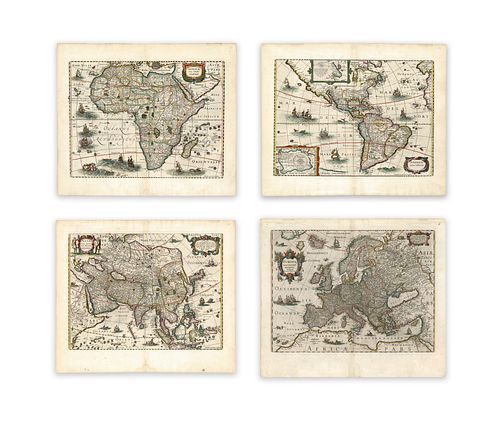
Hondius, Henricus; Janssonius, Johannes. Map Set (4 Maps)
Lot 122
Categories
Estimate:
$15,000 - $19,000
Absentee vs Live bid
Two ways to bid:
- Leave a max absentee bid and the platform will bid on your behalf up to your maximum bid during the live auction.
- Bid live during the auction and your bids will be submitted real-time to the auctioneer.
Bid Increments
| Price | Bid Increment |
|---|---|
| $0 | $25 |
| $300 | $50 |
| $1,000 | $100 |
| $2,000 | $500 |
| $5,000 | $500 |
| $10,000 | $1,000 |
| $20,000 | $2,000 |
| $50,000 | $5,000 |
| $100,000 | $10,000 |
| $200,000 | $25,000 |
| $500,000 | $50,000 |
| $1,000,000 | $100,000 |
About Auction
By Guernsey's
Sep 23, 2020
Set Reminder
2020-09-23 12:00:00
2020-09-23 12:00:00
America/New_York
Bidsquare
Bidsquare : The Legendary Vladi Collection of Historical Maps
https://www.bidsquare.com/auctions/guernseys/the-legendary-vladi-collection-of-historical-maps-5507
Featuring over 300 examples of the finest quality antique maps, with proceeds benefiting MapAction, an organization that uses maps to aid those in disaster-stricken areas. Guernsey's auctions@guernseys.com
Featuring over 300 examples of the finest quality antique maps, with proceeds benefiting MapAction, an organization that uses maps to aid those in disaster-stricken areas. Guernsey's auctions@guernseys.com
- Lot Description
Hondius, Henricus; Janssonius, Johannes
Untitled
C. 1631
Copperplate engraving; coloured
Printed area of each: 53.3 x 39.7 cm; 21 x 15.6 in
A famous map-set, originally published separately as a map of four continents with borders. In this edition of the set, the frames have been trimmed in order to make them fit into the Atlas format.
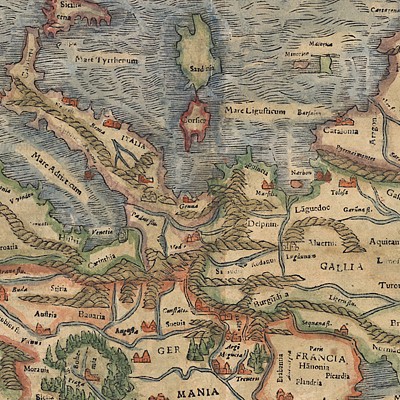
The four maps are characterized by both cartographic and decorative nuances: the seas are filled with sailboats and vessels - in part of continental origin - and with sea monsters with humanoid features. The land is decorated with representations of fauna typical of the respective locations, and place names are also featured, giving the impression of well-explored continents. The African map is in keeping with Ptolemy's previous representations. The Nile is shown with its source as 'Lacus Zaire' and 'Zaflan.' The map of the Americas shows the northernmost point of Antarctica or Terra incognitia. It is not clearly pointed out whether Terra del Fuego is connected to Antarctica. The eastern coast of North America is markedly more detailed than the west coast, largely due to trade and the discoveries. Unsurprisingly, the European continent is the most accurate in the set. As well as being a very accurate depiction, the map also benefits from an elaborately decorated cartouche. Typical Renaissance decor frames the inscription, and surveying and artist tools honour the work of the executive workshop. The continent itself is without any adornments, however, making a marked contrast to the neighbouring land masses, where wildlife is shown. The Asian title cartouche is the only one which is flanked by local staffage, featuring a group of Asiatic hunters. Korea is shown as a peninsula, with an odd projection of Japan.
From the Legendary Vladi Collection of Historical Maps which includes 280 examples of the finest quality antique maps brought to auction with proceeds benefiting MapAction, an organization that uses maps and technology to aid those in disaster-stricken areas. Each map is accompanied by a certificate of authenticity issued by the consignor.
Condition: Map 1: center fold, markings on upper right margin, remains of fixations, light staining; map 2: center fold, markings on upper right margin, remains of fixations; map 3: center fold, remains of fixations, light damp stain upper right and left margins, fixation on lower center fold; map 4: center fold, remains of fixations, edge chippings, light damp stain, rupture of lower center fold; all printed area in very good condition.
This item will be shipped from Hamburg, Germany. Shipping details are to be coordinated with our recommended shipper - Shipping Info
-
Guernsey's does not provide in-house packing and shipping services. Shipping, handling and insurance costs are the responsibility of the winning bidder. The majority of lots are being sold FOB Hamburg, Germany, and a lesser number of lots are being sold FOB Halifax, Canada. The description of each lot will indicate where the item is located, and from which country shipping to the successful winning bidder can be arranged. Should you wish to learn more about your shipping options, please contact Guernsey's by email at auctions@guernseys.com prior to the auction.
-
- Buyer's Premium


 EUR
EUR CAD
CAD AUD
AUD GBP
GBP MXN
MXN HKD
HKD CNY
CNY MYR
MYR SEK
SEK SGD
SGD CHF
CHF THB
THB


