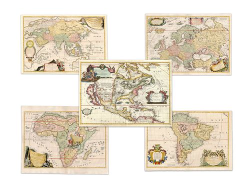
Coronelli, Vincenzo Maria. World and continents (set)
Lot 57
Categories
Estimate:
$48,000 - $60,000
Absentee vs Live bid
Two ways to bid:
- Leave a max absentee bid and the platform will bid on your behalf up to your maximum bid during the live auction.
- Bid live during the auction and your bids will be submitted real-time to the auctioneer.
Bid Increments
| Price | Bid Increment |
|---|---|
| $0 | $25 |
| $300 | $50 |
| $1,000 | $100 |
| $2,000 | $500 |
| $5,000 | $500 |
| $10,000 | $1,000 |
| $20,000 | $2,000 |
| $50,000 | $5,000 |
| $100,000 | $10,000 |
| $200,000 | $25,000 |
| $500,000 | $50,000 |
| $1,000,000 | $100,000 |
About Auction
By Guernsey's
Sep 23, 2020
Set Reminder
2020-09-23 12:00:00
2020-09-23 12:00:00
America/New_York
Bidsquare
Bidsquare : The Legendary Vladi Collection of Historical Maps
https://www.bidsquare.com/auctions/guernseys/the-legendary-vladi-collection-of-historical-maps-5507
Featuring over 300 examples of the finest quality antique maps, with proceeds benefiting MapAction, an organization that uses maps to aid those in disaster-stricken areas. Guernsey's auctions@guernseys.com
Featuring over 300 examples of the finest quality antique maps, with proceeds benefiting MapAction, an organization that uses maps to aid those in disaster-stricken areas. Guernsey's auctions@guernseys.com
- Lot Description
Coronelli, Vincenzo Maria
Set of Five Maps (Coronelli)
1691
Copperplate engraving; coloured
Printed area:
South America: 59.8 x 87.8 cm; 23.5 x 34.6 in
Europe and Asia: 60.2 x 89.2 cm; 23.7 x 35.1 in
Africa: 60.4 x 87.8 cm; 23.8 x 34.6 in
Asia: 59.5 x 87.6 cm; 23.4 x 34.5 in
North America: 59.8 x 87.8 cm; 23.5 x 34.6 in
Although dated 1688, there is no evidence that this map appeared prior to its inclusion in Coronelli's 'Atlante Veneto', which is thought to have been published in either 1690 (as written on the title page) or 1691 (as suggested in the colophon). The 'Atlante Veneto' was professionally designed as a continuation of Blaeu's 'Atlas Major' and was extended to embrace up to twelve volumes (1701). It is a set of all five continents, each on two-sheeted maps. They are all decorated with large cartouches engraved by de Bry. As cartographer for Louis XiV, Coronelli had direct access to the latest cartographical information, largely by means of valuable reports produced by French explorers such as Marquette (1673) and La Salle (1682). The map of North America is the largest scale map of North America of its time. Whilst California is still depicted as an island, the map is believed to have been based on the most up-to-date information of the time. The outline of the South American map is well-chart, with every port and bay identified and named in detail.
The interior is filled with geographical detail and various sketches of local flora and fauna appear, both real and imagined. The map is illustrated with numerous depictions of warring native Indians and European settlers. The European map extends from Iceland (showing volcanoes) and the coast of North America onto Russia, Ukraine, and the Caspian Sea. it includes a sea monster being attacked by two boats. On the African map, the title is draped with palm trees and figures of animals. A large vignette of the source of the Nile is shown to the middle of the right-hand sheet. The map of Asia was very advanced for its time and includes a panel of text acknowledging the extensive geographical activities of the Jesuits to the left of the map. It is thought that Coronelli may have collaborated with the French map-maker Jean Nicholas de Tillemont in obtaining the up-to-date geographical information on Asia. Australia's western and northern coast appear complete and Tasmania and part of New Zealand are also represented, reflecting Abel Tasman's first voyage of discovery (1642-1643).
From the Legendary Vladi Collection of Historical Maps which includes 280 examples of the finest quality antique maps brought to auction with proceeds benefiting MapAction, an organization that uses maps and technology to aid those in disaster-stricken areas. Each map is accompanied by a certificate of authenticity issued by the consignor.
Condition: North America: center fold, light staining on lower printed area, overall excellent condition;
South America: center fold, light edge chippings on lower and right margin, overall excellent condition;
Europe: center fold, light edge chippings on left margin as well as upper right corner, one red stain on right margin slightly reaching into printed area, overall excellent condition;
Africa: center fold, overall excellent condition;
Asia: center fold, overall excellent condition.
This item will be shipped from Hamburg, Germany. Shipping details are to be coordinated with our recommended shipper - Shipping Info
-
Guernsey's does not provide in-house packing and shipping services. Shipping, handling and insurance costs are the responsibility of the winning bidder. The majority of lots are being sold FOB Hamburg, Germany, and a lesser number of lots are being sold FOB Halifax, Canada. The description of each lot will indicate where the item is located, and from which country shipping to the successful winning bidder can be arranged. Should you wish to learn more about your shipping options, please contact Guernsey's by email at auctions@guernseys.com prior to the auction.
-
- Buyer's Premium


 EUR
EUR CAD
CAD AUD
AUD GBP
GBP MXN
MXN HKD
HKD CNY
CNY MYR
MYR SEK
SEK SGD
SGD CHF
CHF THB
THB


