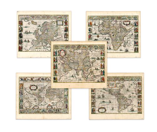
Blaeu, Willem Jansz.. Set of Five Maps (Blaeu)
Lot 34
Categories
Estimate:
$70,000 - $80,000
Absentee vs Live bid
Two ways to bid:
- Leave a max absentee bid and the platform will bid on your behalf up to your maximum bid during the live auction.
- Bid live during the auction and your bids will be submitted real-time to the auctioneer.
Bid Increments
| Price | Bid Increment |
|---|---|
| $0 | $25 |
| $300 | $50 |
| $1,000 | $100 |
| $2,000 | $500 |
| $5,000 | $500 |
| $10,000 | $1,000 |
| $20,000 | $2,000 |
| $50,000 | $5,000 |
| $100,000 | $10,000 |
| $200,000 | $25,000 |
| $500,000 | $50,000 |
| $1,000,000 | $100,000 |
About Auction
By Guernsey's
Sep 23, 2020
Set Reminder
2020-09-23 12:00:00
2020-09-23 12:00:00
America/New_York
Bidsquare
Bidsquare : The Legendary Vladi Collection of Historical Maps
https://www.bidsquare.com/auctions/guernseys/the-legendary-vladi-collection-of-historical-maps-5507
Featuring over 300 examples of the finest quality antique maps, with proceeds benefiting MapAction, an organization that uses maps to aid those in disaster-stricken areas. Guernsey's auctions@guernseys.com
Featuring over 300 examples of the finest quality antique maps, with proceeds benefiting MapAction, an organization that uses maps to aid those in disaster-stricken areas. Guernsey's auctions@guernseys.com
- Lot Description
Blaeu, Willem Jansz.
Set of Five Maps (Blaeu)
1634
Copperplate engraving; old coloured
Printed area:
World: 54.2 x 40.5 cm; 21.3 x 15.9 in
America: 55 x 40.5 cm; 21.7 x 15.9 in
Europe: 55.5 x 40.7 cm; 21.9 x 16 in
Africa: 55.5 x 40.7 cm; 21.9 x 16 in
Asia: 55.5 x 40.5 cm; 21.9 x 15.9 in
This five-piece set by the renowned Dutch cartographer Willem Jansz. Blaeu consists of various individual maps of the continents Europe, Africa, Asia, and America. These individual maps are complemented by a map of the known world.
The continents are bordered on both sides and include depictions of indigenous people wearing clothing typical of the respective regions. The map, therefore, serves as a wonderful source of information about the customs of the 17th century - albeit in the somewhat stereotypical manner of the era. Further decoration comes in the form of a title cartouche, a compass rose, ships, and sea monster. The mapped territories are marked in separate colours, with labels written in Latin. On verso, a German text containing studies of the various regions can be found. The custom-made, valuable framework is optimally aligned for double-sided printing.
The maps contain many interesting features, such as the upper cartouche, which attributes the discovery of the United States to Columbus and also refers to Amerigo Vespucci, who gave his name to the New World. Observers will also note that the American West Coast is not an accurate representation. Information gathered relating to this was based on the estimations of the Native Americans, who told of large landmasses and huge lakes towards the west of the continent. Australia is mentioned but is not represented on the map. Views of the North and South Pole can be found within supplementary maps. The Southern Hemisphere is referred to as "Terra Australis incognita" and features a reference to a large continent. This reference is indicative of the commonly held assumption that for every large landmass in the north, there must be an equivalent in the south. Both allegorical depictions of the Sun, the Moon and the Planets and portrayals of the seven wonders of the ancient world can be found within the map, with illustrations of the Hanging Gardens of Babylon, the Colossus at Rhodes, the Pyramids, the Mausoleum of Halicarnassus, the Temple of Diana, the Statue of Jupiter and the Lighthouse at Alexandria all present. The left-hand side of the map also features human incarnations of the four elements (Fire, Air, Water, and Earth) whereas the right-hand side features the Four Seasons - depicted in such a way that the various ages of man can be seen.
The world map was originally intended to appear as a stand-alone work. Indeed, 'Nova Totius Terrarum Geographica' is arguably one of the most famous world maps of the Baroque Era. It was later incorporated within two of the era's most expensive books ('Atlas Appendix' and 'Atlas Novus' - both by Blaeu), and had enormous influence throughout the cartographical community.
The map of the Americas concentrates on Central and South America, with much of North America dominated by an inset map of Greenland and the mythical island of Friesland. Unlike many other maps of the continent, the presentation ends south of Tierra del Fuego. Unexplored areas in South America are filled with depictions of indigenous or topographical details.
The small, coloured cityscapes of the European map show Amsterdam, Prague, Constantinople, Venice, Rome, Paris, London, Toledo, and Lisbon - all cities of great interest to the Dutch, whether due to trading connections or rivalries. Constantinople contains a representation of the Hagia Sophia, and Venice shows the Grand Canal and the Rialto Bridge.
The map of Asia appeared for the first time in 1617 as an independent publication, circulating in various editions until 1658. The likes of Kandy, Calcutta, Goa, Damascus, Jerusalem, Hormoz, Bantam, Aden, and Macao are all shown, demonstrating the dominance of the Dutch in the eastern territories. Bantam was appointed as the first permanent Dutch trading post in the region in 1609, some 15 years after it was first explored.
The African map is probably one of the most decorative, early representations of Africa. The seas are filled with depictions of sailing ships, merchant ships, and various sea monsters. And the land is inhabited by native animals. Detailed entries and location information suggest a well-known continent. in reality, however, it was - to a large extent - an uncharted territory.
From the Legendary Vladi Collection of Historical Maps which includes 280 examples of the finest quality antique maps brought to auction with proceeds benefiting MapAction, an organization that uses maps and technology to aid those in disaster-stricken areas. Each map is accompanied by a certificate of authenticity issued by the consignor.
Condition: World: Center fold, edge chippings/light rupture on upper margin and upper right corner, one minor crease on upper margin, light staining, markings on lower margin;
America: center fold, light staining, markings on lower right corner;
Africa: center fold, light staining, markings on lower right corner;
Asia: center fold, light staining, markings on lower right corner;
Europe: center fold, light staining, two stains on lower margin;
Overall all five maps are in excellent condition.
This item will be shipped from Hamburg, Germany. Shipping details are to be coordinated with our recommended shipper - Shipping Info
-
Guernsey's does not provide in-house packing and shipping services. Shipping, handling and insurance costs are the responsibility of the winning bidder. The majority of lots are being sold FOB Hamburg, Germany, and a lesser number of lots are being sold FOB Halifax, Canada. The description of each lot will indicate where the item is located, and from which country shipping to the successful winning bidder can be arranged. Should you wish to learn more about your shipping options, please contact Guernsey's by email at auctions@guernseys.com prior to the auction.
-
- Buyer's Premium


 EUR
EUR CAD
CAD AUD
AUD GBP
GBP MXN
MXN HKD
HKD CNY
CNY MYR
MYR SEK
SEK SGD
SGD CHF
CHF THB
THB


