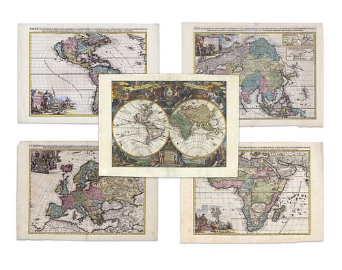
Aa, Pieter van der. World and continents (set)
Lot 1
Categories
Estimate:
$24,000 - $30,000
Absentee vs Live bid
Two ways to bid:
- Leave a max absentee bid and the platform will bid on your behalf up to your maximum bid during the live auction.
- Bid live during the auction and your bids will be submitted real-time to the auctioneer.
Bid Increments
| Price | Bid Increment |
|---|---|
| $0 | $25 |
| $300 | $50 |
| $1,000 | $100 |
| $2,000 | $500 |
| $5,000 | $500 |
| $10,000 | $1,000 |
| $20,000 | $2,000 |
| $50,000 | $5,000 |
| $100,000 | $10,000 |
| $200,000 | $25,000 |
| $500,000 | $50,000 |
| $1,000,000 | $100,000 |
About Auction
By Guernsey's
Sep 23, 2020
Set Reminder
2020-09-23 12:00:00
2020-09-23 12:00:00
America/New_York
Bidsquare
Bidsquare : The Legendary Vladi Collection of Historical Maps
https://www.bidsquare.com/auctions/guernseys/the-legendary-vladi-collection-of-historical-maps-5507
Featuring over 300 examples of the finest quality antique maps, with proceeds benefiting MapAction, an organization that uses maps to aid those in disaster-stricken areas. Guernsey's auctions@guernseys.com
Featuring over 300 examples of the finest quality antique maps, with proceeds benefiting MapAction, an organization that uses maps to aid those in disaster-stricken areas. Guernsey's auctions@guernseys.com
- Lot Description
Aa, Pieter van der
Set of Five Maps (AA, Pieter Van Der)
1713
Copperplate engraving; Later colour
Printed area:
America: 65.7 x 47.2 cm; 25.9 x 18.6 in
Europe: 65.3 x 47 cm; 25.7 x 18.5 in
Africa: 65 x 47.5 cm; 25.6 x 18.7 in
Asia: 65.2 x 47 cm; 25.7 x 18.5 in
World: 62.5 x 49.5 cm; 24.6 x 19.5 in
A set of four large maps of the continents - each with a fine, full-colour title cartouche - first published in Van der Aa's atlas, 'Le Nou- veau theatre du monde.' In contrast to other contemporary maps of the world, the double hemisphere map dispenses with the delineation of depictions of a huge sub-continent in the Antarctic and gigantic expansions of North America and Australia.
With the exception of a few speculative coastlines, unknown regions are left blank, resulting in the northwestern extension of North America being left blank. By the 16th Century, it was largely common knowledge that California was a peninsula. Yet despite evidence to the contrary, this cartographic error went on to be reproduced many times. Whilst the western and northern coastlines of Australia are visible, the continent is still shown as being connected to New Guinea. The title (towards the bottom-middle) is written in French and states that the map is based on the latest results from the 'Academie des Sciences' - an institution founded by Louis XIV in 1666. Numerous and imaginative pictures populate the border region containing representations of exotic animals and landscapes. Allego- rical representations of the continents and valuable trade goods are shown, as are The four elements - with fire and wind towards the top and land and water towards the bottom.
Crowned at the top is a model of earth and sun in a universe shrouded with clouds. The Asian map shows (of course) the continent of Asia, but extends far beyond the usual depictions - starting in the British isles / East Africa and continuing as far as Papua New Guinea.
The inset (upper right) details the North East coast of China based on memoirs of the Jesuit Martini and is accompanied by a second inset based on the memoirs of the Jesuit Verbiest. On the American map, the British colonies are confined to the Eastern seaboard by 'Les Cinq Nationals Iroquois.' The French colonies, on the other hand, extend to the Mississippi River. The Spanish colonization includes the Carolinas, Florida and the Gulf of Mexico coastal regions. Nova Mexicans and Nova Granada take up nearly all of the west coast. in South America, the Amazon is the most prominent feature. The Orinoco is confused with the River Negro. interestingly, the maps also include an exceptional and unusually detailed rendition of the Great Lakes as well as a number of annotations. other quirks include the projection of South America, which is unusually wide for the period. The cartouche features a wonderful Indian Village scene.
in the foreground of the African map is a partial view of an elephant, a lion, and a coiled snake. There is a compromise in the mapping of the Nile basin, showing the river rising from Lake Tzana in an area marked Demba. The Ptolemaic lakes Zaire and Zaflan are, however, retained, but unconnected to the Nile. The map also shows both the Cape settlements in the south and the Portuguese ones on the lower eastern coastline and on the mainland. The cartouche on the European map shows two allegorical representations of Europe. Europe is shown upon a throne, regally dressed and surrounded by fruit baskets and other symbols of wealth. At the same time, the allegory is illustrated with the bull.
From the Legendary Vladi Collection of Historical Maps which includes 280 examples of the finest quality antique maps brought to auction with proceeds benefiting MapAction, an organization that uses maps and technology to aid those in disaster-stricken areas. Each map is accompanied by a certificate of authenticity issued by the consignor.
Condition: Map of the world: center fold, markings on lower right corner, light staining on margin, fixations on upper margin, light edge chippings on left and lower margin, printed area in excellent condition;
Map of Europe: center fold, edge chippings on upper right corner, light edge chippings on left and lower margin, light staining on margins and printed area, very good condition;
Map of Asia: center fold, pink discolouration on upper margin next to center fold, light staining on margins, printed area in excellent condition;
Map of America: center fold, light edge chippings on lower and right margin as well as lower left corner, printed area in excellent condition;
Map of Africa: center fold, edge chippings on upper and lower margin, light foxing and staining on margins, printed area in very good condition
This item will be shipped from Hamburg, Germany. Shipping details are to be coordinated with our recommended shipper - Shipping Info
-
Guernsey's does not provide in-house packing and shipping services. Shipping, handling and insurance costs are the responsibility of the winning bidder. The majority of lots are being sold FOB Hamburg, Germany, and a lesser number of lots are being sold FOB Halifax, Canada. The description of each lot will indicate where the item is located, and from which country shipping to the successful winning bidder can be arranged. Should you wish to learn more about your shipping options, please contact Guernsey's by email at auctions@guernseys.com prior to the auction.
-
- Buyer's Premium


 EUR
EUR CAD
CAD AUD
AUD GBP
GBP MXN
MXN HKD
HKD CNY
CNY MYR
MYR SEK
SEK SGD
SGD CHF
CHF THB
THB


