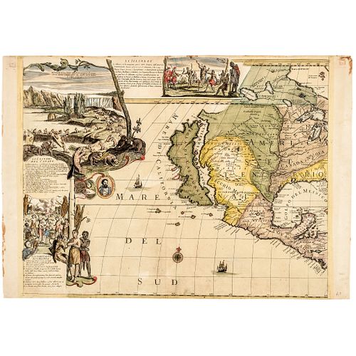
c 1700 Handcolored Engraved Map of Western American with California as an Island
Lot 300
Categories
Estimate:
$8,000 - $10,000
Absentee vs Live bid
Two ways to bid:
- Leave a max absentee bid and the platform will bid on your behalf up to your maximum bid during the live auction.
- Bid live during the auction and your bids will be submitted real-time to the auctioneer.
Bid Increments
| Price | Bid Increment |
|---|---|
| $0 | $10 |
| $200 | $20 |
| $300 | $25 |
| $500 | $50 |
| $1,000 | $100 |
| $2,000 | $200 |
| $3,000 | $250 |
| $5,000 | $500 |
| $10,000 | $1,000 |
| $20,000 | $2,000 |
| $30,000 | $2,500 |
| $50,000 | $5,000 |
| $100,000 | $10,000 |
| $200,000 | $20,000 |
| $300,000 | $25,000 |
| $500,000 | $50,000 |
About Auction
By Early American History Auctions
Jan 23, 2021
Set Reminder
2021-01-23 12:00:00
2021-01-23 12:00:00
America/New_York
Bidsquare
Bidsquare : Early American History Auction of Autographs, Americana, Political & Maps
https://www.bidsquare.com/auctions/early-american-history-auctions/early-american-history-auction-of-autographs-americana-political-maps-6311
311 Lots of Rare, Historic Autographs, Americana, Civil War Era, George Washington, Abraham Lincoln, Slavery & Black History, Revolutionary War Era, Colonial America, Federal Period, War of 1812, Colonial Currency, Indian Peace Medals & more... Early American History Auctions auctions@earlyamerican.com
311 Lots of Rare, Historic Autographs, Americana, Civil War Era, George Washington, Abraham Lincoln, Slavery & Black History, Revolutionary War Era, Colonial America, Federal Period, War of 1812, Colonial Currency, Indian Peace Medals & more... Early American History Auctions auctions@earlyamerican.com
- Lot Description
Historic Maps
Petrini Paolo's "L'America Dedicata all'Illustriss..." Map of Western American with California as an Island & Vignettes
c. 1700, Hand-Colored Copper Plate Engraved Map, Upper Left Portion of Petrini Paolo's L'America Dedicata all'Illustriss. ed Eccell.mo Sig.re D. Vincenzo di Capova Duca di Termoli, Conte d'Anversa, Separately Issued, Italy, Choice Very Fine.
An extraordinarily rare colorful Hand-Colored Map of North America by Paolo Petrini. Petrini was active in Naples at the end of the 17th and early 18th Century. This impressive highly detailed and colorful upper left portion of Petrini Paolo's 4-quadrant Copper-Plate Engraved Map measures about 22.25" wide x 18.5" high. Slight extreme top edge marginal tone and trivial hinge trace at upper right corner tip, having wide right and left marginal selvage, nicely printed on solid double-page laid period paper with "fleur-de-lis" watermark, attesting to its orignality.
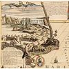
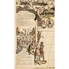
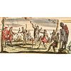
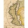
This portion is the upper left quadrant with the famous "Beaver Scene" titled, "Li castori del Canada" where the beavers are industriously building a dam in front of Niagara falls (depicted for the first time in 1697 in Louis Hennepin's Nouvelle decouvert...). Also depicted; a scene of Indians titled, "Li Illinesi" and a group of Natives Indians titled, "GLi Habitanti Di Virginia". Two of the Great lakes are shown, Superior and Illinese (Michigan), and the Mississippi River is present, although its mouth is located far southwest of its true location. In the view of the West, California is shown to be a large separate Island. A medallion with a Portrait of Magellano just below the American "Beaver" scene. Very little is known of Paolo Petrini, the Neapolitan mapmaker. He is known to have published the rare Atlante partenopeo (1700-1718), and the equally rare set of wall-maps of the continents. Much of his work appears to have been based on contemporary French mapping, notably the works of the Sanson family and Nicolas de Fer.
This is certainly the best of the quadrant maps as in the west, California is shown to be a massively large Island with smaller islands around it, while in the Pacific Northwest, the coast curves inwards to include the mythical "Strait of Anian." This Map is surrounded by large borders with wonderful highly decorative scenes placed in the body of plate and not printed on a separate sheet later added. There are two main scenes in the upper corners. Top left, the famous "Beaver scene" titled Li castori del Canada where the beavers are industriously building a dam in front of Niagara falls (depicted for the first time in 1697 in Louis Hennepin's Nouvelle decouverte...)
Top central vignette shows Native American Indians smoking and sharing their "Peace Pipes" to the sword bearing Europeans dressed in their bold red military garments and hats. An excellent highly colorful, attractive and distinctive map for display. This map was apparently separately issued Petrini's maps are considered great rarities and are highly collectable. This is the only example we have offered in the past 35 years. A completely issued Map, located online, being of lesser quality with minimal outline color only and soiling, is currently offered for sale offered at $35,000 Euros (Currently: About $42,390 United States Dollars). More extensive information is provided in our Online Auction version at: www.EarlyAmerican.com. Reference: McLaughlin, California as an island, 139.
PETRINI PAOLO - MAP
A complete "L'America Dedicata all'Illustriss. ed Eccell.mo Sig.re D. Vincenzo di Capova Duca di Termoli, Conte d'Anversa" Located online in lesser quality is currently for sale with minimal outline color only: Offered at $35,000 Euros (Currently: About $42,390 United States Dollars).
Date: Naples, (1700 about). AMERICA: The Full Four Quadrant Map:
Copper engraving in four joined sheets, total dimension 35 " x 45 " (each sheet measures 17 x 22 ".
Extremely rare classic wall map published in Naples by Petrini as a separately-issued map, but sometimes included in his "Atlante Partenopeo", an almost unknown atlas, printed in a very few number of copies in two issues of 1700 and 1718 c. Petrini bases his map on the sources of the previous map "L'Amerique divise selon letendue de ses principals parties...dresse par Nicolas De Fer...a Paris...1698" by N. De Fer (1646-1720), known as "the Beaver map" most noted for introducing to the world of cartography its Beaver scenes.
This first De Fer edition is extraordinarily rare and many author of cartographical bibliographies (Tooley, McLaughlin) are not able to trace editions before the second 1705 printing. This makes the Petrini's the second map featuring the new image of America introducted by De Fer, but actually the first very rarely obtainable map for collectors.
All later De Fer editions are following the Petrini map. Petrini is also following Coronelli, a venetian cartographer of the late XVII century. The depiction of the Americas is in good part based on his maps of North and South America, from his Atlante Veneto (Venice, circa 1690). Eastern North America is reasonably well-defined, with all five of the Great Lakes delineated. The Mississippi River is present, although its mouth is located far southwest of its true location.
In the west, California is shown to be a large Island, while in the Pacific Northwest, the coast curves inwards to include the mythical Strait of Anian. South America takes on an exaggerated, widened form, although the Andes and major rivers are depicted with a broad degree of accuracy. The map is surrounded by large bordures with decorative scenes placed in the body of plate and not printed on a separate sheet later added. There are two main scenes in the upper corners. Top left, the famous "Beaver scene" titled Li castori del Canada where the beavers are industriously building a dam in front of Niagara falls (depicted for the first time in 1697 in Louis Hennepin's Nouvelle decouverte...).
The top right inset scene La pesca del Baccal illustrates the typical cod-finishing factory found along the Newfoundland coast. Both the scenes are to be found in later maps. Further images were of Canadian savages (I Salvagi del Canada) and Indians (I Illinesi). On side borders, left Li habitanti di Virginia and Li Brasiliani, right Gli antichi Messicani and Gli habitanti del Nuovo Mondo. At bottom from left Li habitanti di Chili, Gli Habitanti del Peru, Gli habitanti a torno il Rio di Plata, Li Buccanieri. All around the map we find 6 medallions with portraits of Magellano, Artha-Balipa, Colombo (left) and Francesco Pisar, Mote-Zuma re del Messico, Americo Vespuse (right).
Very little is known of Paolo Petrini, the Neapolitan Mapmaker. He is known to have published the rare Atlante partenopeo (1700-1718), and the equally rare set of wall-maps of the continents. Much of his work appears to have been based on contemporary French mapping, notably the works of the Sanson family and Nicolas de Fer. However, he was also an original author; it may be seen from his map of Asia, which demonstrates the use of more up-to-date sources where available. References: McLaughlin, California as an island, 139.
- Shipping Info
-
Early American provides in-house worldwide shipping. Please contact us directly if you have questions about your specific shipping requirements.
-
- Buyer's Premium


 EUR
EUR CAD
CAD AUD
AUD GBP
GBP MXN
MXN HKD
HKD CNY
CNY MYR
MYR SEK
SEK SGD
SGD CHF
CHF THB
THB