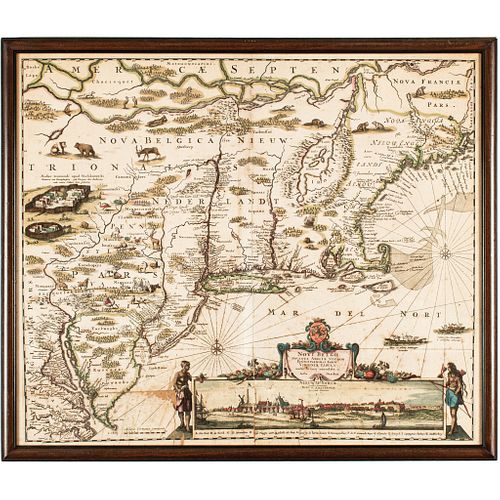
c. 1684 Hand-Colored Map, American Northeast, Novi Belgii Noveque Anglinae...
Lot 299
Categories
Estimate:
$4,500 - $6,500
Absentee vs Live bid
Two ways to bid:
- Leave a max absentee bid and the platform will bid on your behalf up to your maximum bid during the live auction.
- Bid live during the auction and your bids will be submitted real-time to the auctioneer.
Bid Increments
| Price | Bid Increment |
|---|---|
| $0 | $10 |
| $200 | $20 |
| $300 | $25 |
| $500 | $50 |
| $1,000 | $100 |
| $2,000 | $200 |
| $3,000 | $250 |
| $5,000 | $500 |
| $10,000 | $1,000 |
| $20,000 | $2,000 |
| $30,000 | $2,500 |
| $50,000 | $5,000 |
| $100,000 | $10,000 |
| $200,000 | $20,000 |
| $300,000 | $25,000 |
| $500,000 | $50,000 |
About Auction
By Early American History Auctions
Jan 23, 2021
Set Reminder
2021-01-23 12:00:00
2021-01-23 12:00:00
America/New_York
Bidsquare
Bidsquare : Early American History Auction of Autographs, Americana, Political & Maps
https://www.bidsquare.com/auctions/early-american-history-auctions/early-american-history-auction-of-autographs-americana-political-maps-6311
311 Lots of Rare, Historic Autographs, Americana, Civil War Era, George Washington, Abraham Lincoln, Slavery & Black History, Revolutionary War Era, Colonial America, Federal Period, War of 1812, Colonial Currency, Indian Peace Medals & more... Early American History Auctions auctions@earlyamerican.com
311 Lots of Rare, Historic Autographs, Americana, Civil War Era, George Washington, Abraham Lincoln, Slavery & Black History, Revolutionary War Era, Colonial America, Federal Period, War of 1812, Colonial Currency, Indian Peace Medals & more... Early American History Auctions auctions@earlyamerican.com
- Lot Description
Historic Maps
Stunning Late 17th Century Map of the American Northeast With "Nieuw Yorck. - Nieuw Amsterdam" Cityscape Inset
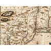
c. 1684 Late 17th Century, Hand-Colored Map of the American Northeast titled, "Novi Belgii Noveque Anglinae Nec Son Pennsylvaniae et Partis Virginiae Tabula" by Justus Danckerts, Netherlands, Framed, Very Fine.
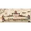
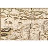
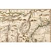
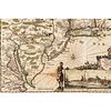
c. 1684 Map of the American Northeast Double-Sheet Map measuring 22" x 18.75" (by sight), titled, "Novi Belgii Noveque Anglinae Nec Son Pennsylvaniae et Partis Virginiae Tabula." This beautiful highly illustrated Map was engraved by Justus Danckerts of the Netherlands and is considered part of the Jansson-Visscher series of Maps. Overall, this Map is in pleasing condition, possibly laid down when framed for display, having some faint folds and standard centerfold lines with some scattered short separations, minor wrinkles and a small loss of paper with a fine split in the lower left quadrant measuring about 1" x 1", left of the Native American Indian vignette that appears to blend into the scene. The series began with the Dutchman Joannes Jansson's c. 1651 "Belgii Novi", which was first published in Amsterdam and patriotically depicts a sprawling Dutch "New Netherlands" with a tiny New England confined east of the Connecticut River. Jansson's Map was copied by another Dutchman, Nicholas Visscher, in 1655, who enhanced his Map's popular appeal by introducing an inset Cityscape view of "New Amsterdam" titled, "Nieuw Yorck. - Nieuw Amsterdam" at lower right. Numerous placed native American animals displayed in this current version including; Turkey, Rabbits, Beaver, Bear, hog, goat, horses, deer, cattle, sheep, fox cranes and more enhance the appeal of this version, appropriated for this map by Danckerts, often called the "Farm Animal" Map.
Danckerts drew multiple states of this map, per Philip D. Burden's definitive work, "The Mapping of North America." Offered here is the third state of Danckerts' Map, which appeared in or around 1684 after the establishment of Philadelphia. By the time this map appeared, the English had wrested the New Netherlands from the Dutch, William Penn had founded Pennsylvania, and geographic knowledge of the region had advanced considerably. These developments necessitated substantial revisions to the map, as described by Burden:
"Following the founding of Philadelphia a revised state was produced. However, unlike the competing maps (i.e., other post-1682 maps in the Jansson-Visscher series) which largely confined themselves to the city's addition, Danckerts updated the map in a significant manner. The Delaware River is completely revised so that it no longer connects with the Hudson River. Richard Daniel's A Map of ye English Empire... c. 1679, had depicted a similar river system. Pennsylvania is named, its boundary is marked, and many largely domesticated animals are engraved within the region. Recognition of the English hold over New Amsterdam is seen in the addition to the title to the view of "Nieuw Yorck, eertys Genaemt..."
For all these important alterations, Danckerts could not bring himself to acknowledge the fundamental geopolitical shift represented by the English conquest of the New Netherlands. This rare third state still depicts a vast "Nova Belgica sive Nieuw Nederlandt" dwarfing tiny New England, and the only allusion to New York is, as observed by Burden, in the title of the inset Cityscape view. We note that a West Coast Map Dealer is offering a similar example for sale at $7,500. We will start our bidding at half of that amount. A wonderful, highly illustrated Map.
The Danckerts family (fl. 1628 - 1717) were a Dutch engraving and cartographic publishing firm active in Amsterdam during the latter half of the 17th and early 18th centuries. The firm was most active in this period between 1680 and 1700 when a number of atlases and maps appeared bearing either the Justus Danckerts or Theodorus Danckerts imprint.
At the time, it was in vogue in Amsterdam to leave maps undated, which makes Danckerts maps particularly difficult to ascribe. Similarly, there is a considerable corpus of maps signed as Cornelius Danckerts. When dated we can correctly attribute these to either Cornelius II or Cornelius III, though, typically, most are undated and consequently difficult to attach to the correct Danckerts family member.
The Danckerts family is well known for its highly detailed and graphic engraving style. In addition to numerous atlas maps, they also produced a number of spectacular Dutch wall maps. In the early 18th century, the Danckerts map plates were purchased by R. and J. Ottens, who reprinted many of them under their own imprint. (Ref: Keuning, J., "Cornelis Danckerts and his "Niew Aerdsh Pleyn"", Imago Mundi, Vol. 12 (1955), pp. 136-139.)
- Shipping Info
-
Early American provides in-house worldwide shipping. Please contact us directly if you have questions about your specific shipping requirements.
-
- Buyer's Premium


 EUR
EUR CAD
CAD AUD
AUD GBP
GBP MXN
MXN HKD
HKD CNY
CNY MYR
MYR SEK
SEK SGD
SGD CHF
CHF THB
THB