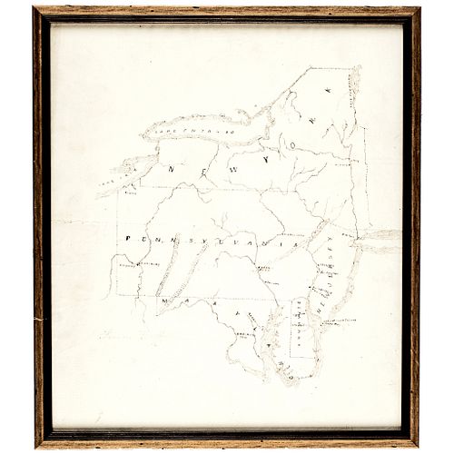
19th Century Hand-Drawn Regional Map of NY, PA, MD, NJ and DE Framed
Lot 326
Categories
Estimate:
$375 - $450
Absentee vs Live bid
Two ways to bid:
- Leave a max absentee bid and the platform will bid on your behalf up to your maximum bid during the live auction.
- Bid live during the auction and your bids will be submitted real-time to the auctioneer.
Bid Increments
| Price | Bid Increment |
|---|---|
| $0 | $10 |
| $200 | $20 |
| $300 | $25 |
| $500 | $50 |
| $1,000 | $100 |
| $2,000 | $200 |
| $3,000 | $250 |
| $5,000 | $500 |
| $10,000 | $1,000 |
| $20,000 | $2,000 |
| $30,000 | $2,500 |
| $50,000 | $5,000 |
| $100,000 | $10,000 |
| $200,000 | $20,000 |
| $300,000 | $25,000 |
| $500,000 | $50,000 |
About Auction
By Early American History Auctions
Mar 20, 2021
Set Reminder
2021-03-20 12:00:00
2021-03-20 12:00:00
America/New_York
Bidsquare
Bidsquare : Autographs-Colonial-Political-Americana
https://www.bidsquare.com/auctions/early-american-history-auctions/autographs-colonial-political-americana-6509
330 Lots of Rare, Historic Autographs, Americana, Civil War Era, George Washington, Abraham Lincoln, Slavery & Black History, Revolutionary War Era, Colonial America, Federal Period, War of 1812, Colonial Currency, Indian Peace Medals & more... Early American History Auctions auctions@earlyamerican.com
330 Lots of Rare, Historic Autographs, Americana, Civil War Era, George Washington, Abraham Lincoln, Slavery & Black History, Revolutionary War Era, Colonial America, Federal Period, War of 1812, Colonial Currency, Indian Peace Medals & more... Early American History Auctions auctions@earlyamerican.com
- Lot Description
Historic Maps
19th Century Original Hand-Drawn Regional Map of New York, Pennsylvania, Maryland, New Jersey, and Delaware
19th Century Hand-Drawn Regional Map of New York, Pennsylvania, Maryland, New Jersey, and Delaware, with Annotations, Professionally Framed, Choice Extremely Fine.
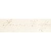
Likely Mid 19th Century, Hand-Drawn Regional Map of New York, Pennsylvania, Maryland, New Jersey, and Delaware, Choice Extremely Fine. This Map, measuring 11.5" x 13.25" (by sight) features these states outlined with fine dashed lines, highlighted with Annotations showing State Capitals, as well as various other Cities, Rivers, and major Bodies of water. Mounted in a simple wooden frame under glass measuring to 12.75" x 14.5. This is a beautifully presented Map with just one horizontal fold line running through the center with some trivial creases, overall clean and sharp in detail. There is a faint inscription to the lower left with only the faint name "Francis Duffy" partially legible as the likely artist. Ready to hand on display.
Our Auction Contents:
Black History & Slavery: (Lots 1 - 63)
Abraham Lincoln Related: (Lots 64 - 74)
Historic Autographs: (Lots 75 - 235)
Colonial America: (Lots 236 - 261)
Revolutionary War: (Lots 262 - 304)
George Washington Related: (Lots 305 - 306)
Early American Guns & Weapons: (Lots 307 - 318) - Shipping Info
-
Early American provides in-house worldwide shipping. Please contact us directly if you have questions about your specific shipping requirements.
-
- Buyer's Premium


 EUR
EUR CAD
CAD AUD
AUD GBP
GBP MXN
MXN HKD
HKD CNY
CNY MYR
MYR SEK
SEK SGD
SGD CHF
CHF THB
THB


