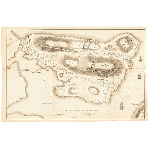
(1826) Important Revolutionary War Map: Sketch of Bunker Hill Battle
Lot 188
Categories
Estimate:
$800 - $1,000
Absentee vs Live bid
Two ways to bid:
- Leave a max absentee bid and the platform will bid on your behalf up to your maximum bid during the live auction.
- Bid live during the auction and your bids will be submitted real-time to the auctioneer.
Bid Increments
| Price | Bid Increment |
|---|---|
| $0 | $10 |
| $200 | $20 |
| $300 | $25 |
| $500 | $50 |
| $1,000 | $100 |
| $2,000 | $200 |
| $3,000 | $250 |
| $5,000 | $500 |
| $10,000 | $1,000 |
| $20,000 | $2,000 |
| $30,000 | $2,500 |
| $50,000 | $5,000 |
| $100,000 | $10,000 |
| $200,000 | $20,000 |
| $300,000 | $25,000 |
| $500,000 | $50,000 |
About Auction
By Early American History Auctions
Mar 20, 2021
Set Reminder
2021-03-20 12:00:00
2021-03-20 12:00:00
America/New_York
Bidsquare
Bidsquare : Autographs-Colonial-Political-Americana
https://www.bidsquare.com/auctions/early-american-history-auctions/autographs-colonial-political-americana-6509
330 Lots of Rare, Historic Autographs, Americana, Civil War Era, George Washington, Abraham Lincoln, Slavery & Black History, Revolutionary War Era, Colonial America, Federal Period, War of 1812, Colonial Currency, Indian Peace Medals & more... Early American History Auctions auctions@earlyamerican.com
330 Lots of Rare, Historic Autographs, Americana, Civil War Era, George Washington, Abraham Lincoln, Slavery & Black History, Revolutionary War Era, Colonial America, Federal Period, War of 1812, Colonial Currency, Indian Peace Medals & more... Early American History Auctions auctions@earlyamerican.com
- Lot Description
American Revolution
Revolutionary War Map: "Sketch of Bunker Hill Battle"
(1826) Engraved Printed Map titled, "Sketch of Bunker Hill Battle," Large Format by S. Swett and engraved by Annin & Smith, Very Fine.
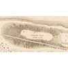
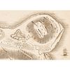
This map measures 12.75" x 19.25", 1 page, no date, based on Thomas Hyde Page's plan of the Battle of Bunker Hill. This Map gives a bird's-eye view of Breed's Hill, where the battle actually took place between British and American Colonial Patriot forces on June 17, 1775. This map appears to have been drawn with a slight bias toward the British, as the lines drawn from the British entrenchments and the ships offshore track their cannonballs directly into the American forces on Breed's Hill. Three ships (the Somerset, Lively, and Falcon) can be seen in the attack. The British warship, Glasgow, is literally "off the chart," but its attack on the Americans at Charlestown Neck can be seen on the left side of the map. Additional cannon and mortar shots were fired from farther away on Copp's Hill at lower right. And, of course, the attack from the British troops that had landed at Morton's (aka Moulton's) Point can be seen at upper right. Essentially, the Americans were receiving fire from several directions and their reinforcements were cut off at Charlestown Neck (upper left). Despite being routed by the British troops, the American forces inflicted greater casualties on the British and won a well-needed boost of confidence. Light toning and foxing, none of which has any marked effect on the overall appearance. Minor edge chipping and small paper loss along the central right edge. A historic display piece relating to one of America's most famous Revolutionary War battles. Reference: Phillips (Maps) p. 181.
This uncommon plan of the battle of Bunker Hill by Samuel Swett was engraved by Annin & Smith and published by Monroe & Francis. It is based on Thomas Hyde Page's plan of the Battle of Bunker Hill. Although the battle resulted in a British victory and loss of control of Boston, the campaign was considered one of the first steps towards American Independence.
Page served as aide-de-campe to General Howe during the action. His plan was first published by Faden and later in Charles Stedman's history of the American Revolution. The map shows cannon fire, lines of attack, British landing places, and British ships in the Charles River. Charlestown is noted as burned down.
Our Auction Contents:
Black History & Slavery: (Lots 1 - 63)
Abraham Lincoln Related: (Lots 64 - 74)
Historic Autographs: (Lots 75 - 235)
Colonial America: (Lots 236 - 261)
Revolutionary War: (Lots 262 - 304)
George Washington Related: (Lots 305 - 306)
Early American Guns & Weapons: (Lots 307 - 318) - Shipping Info
-
Early American provides in-house worldwide shipping. Please contact us directly if you have questions about your specific shipping requirements.
-
- Buyer's Premium


 EUR
EUR CAD
CAD AUD
AUD GBP
GBP MXN
MXN HKD
HKD CNY
CNY MYR
MYR SEK
SEK SGD
SGD CHF
CHF THB
THB