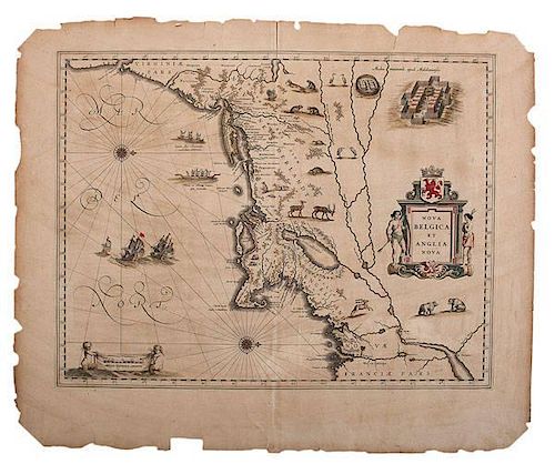
Willem Janszoon Blaeu, Early Map of the New World, 1635
About Seller
6270 Este Ave.
Cincinnati , OH 45232
United States
With offices in Cincinnati, Cleveland and Denver, Cowan’s holds over 40 auctions each year, with annual sales exceeding $16M. We reach buyers around the globe, and take pride in our reputation for integrity, customer service and great results. A full-service house, Cowan’s Auctions specializes in Am...Read more
Two ways to bid:
- Leave a max absentee bid and the platform will bid on your behalf up to your maximum bid during the live auction.
- Bid live during the auction and your bids will be submitted real-time to the auctioneer.
Bid Increments
| Price | Bid Increment |
|---|---|
| $0 | $25 |
| $500 | $50 |
| $1,000 | $100 |
| $2,000 | $250 |
| $5,000 | $500 |
| $10,000 | $1,000 |
| $20,000 | $2,500 |
| $50,000 | $5,000 |
| $100,000 | $10,000 |
About Auction
Jun 12, 2015 - Jun 13, 2015
Cowan's Auctions dawnie@cowans.com
- Lot Description
Blaeu, Willem J. Nova Belgica et Anglia Nova. 1635. Color example of one of the most important maps in the history of America. Oriented to the west, this map covers the American coast from Virginia, past New York and Long Island to Cape Code, New England, and Quebec. It is cartographically derived from data accumulated by Adriaen Bock and other Dutch fur traders active in the early 17th century. It is known for a number of important firsts, including the first full representation of Manhattan as an Island. Plate size approx. 19.8 x 15.3 in.
After Henry Hudson’s rediscovery in 1609 of the river that now bears his name, rapid progress was made in the mapping of New York. Most of the maps of southern New York that appeared in the first three-quarters of the seventeenth century were the work of Dutch explorers and cartographers.
Hudson and his successors quickly determined the configuration of the Hudson River up to the limits of its navigability. In 1613-1614, Adriaen Block, a Dutch explorer and fur trader, sailed around Long Island, and sketched out its overall appearance.
The 1635 Blaeu map of New Netherland and New England reflects these early Dutch explorations. It is largely based on a manuscript map, the famous "Adriaen Block Chart"; of 1614. Long Island (called Matowacs on this map), is shown as broken up by waterways--a feature taken from the Block Chart. Lake Champlain is still displaced far to the east--a feature which Block copied from an unpublished map by Champlain. A number of important place names make their first cartographic appearance on this map. These include "Manhates" (Manhattan), "Hellegat" (Hell Gate), and "Adrian Blocks eylandt" (Block Island). The beginnings of Dutch settlement in this area are reflected in the place names "New Amsterdam" and "Fort Orange" (near Albany). The numerous Dutch place names along the coast of New England are mostly copied from the Block chart, although Plymouth is added.
This and other early Dutch maps are important sources of information about local Indians. A number of tribes are named, including the Mohawks ("Maques") and Mohegans ("Mahikans"). Birch bark and dugout canoes are shown, as well as somewhat fancifully drawn Indian settlements. American wildlife, including turkey and beaver, are also illustrated. These illustrations, which were frequently copied on later maps, were important sources of information about life in the New World for Europeans who remained at home.
The whole map is adorned by deer, foxes, bears, egrets, rabbits, cranes and turkeys. Beavers, polecats and otters appear on a printed map for the first time. The Mohawk Indian village top right is derived from the de Bry-White engravings.
It is of note that this map was issued in a number of editions but only a single state. Editions are generally identified by the text appearing on the verso with twelve documented editions, three each in Dutch, Latin, German, and French.Loosely matted. Irregular margins (appx. 1-12" to 2-3/4") with some chipping along the margin edges, not affecting the image with retains its original color.Condition
- Shipping Info
-
SHIPPING. At the request of the buyer, Cowan's will authorize the shipment of purchased items. Shipments usually occur within two weeks after payment has been received. Shipment is generally made via UPS Ground service. Unless buyer gives special instructions, the shipping method shall be at the sole discretion of Cowan's Auctions, Inc.. Cowan's is in no way responsible for the acts or omissions of independent handlers, packers or shippers of purchased items or for any loss, damage or delay from the packing or shipping of any property.
-
- Buyer's Premium


 EUR
EUR CAD
CAD AUD
AUD GBP
GBP MXN
MXN HKD
HKD CNY
CNY MYR
MYR SEK
SEK SGD
SGD CHF
CHF THB
THB


