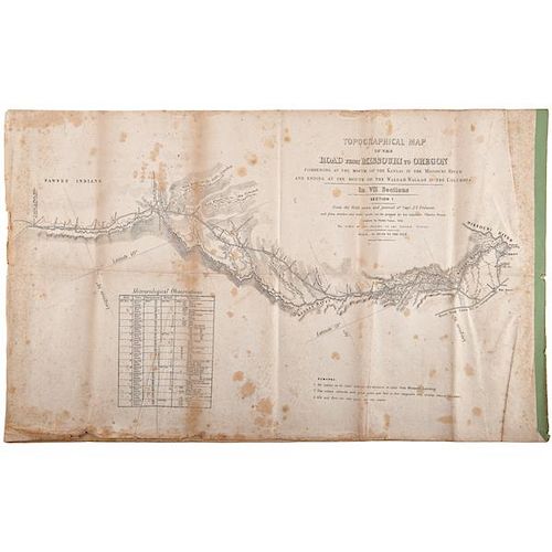
Topographical Map of the Road from Missouri to Oregon, 1846
About Seller
6270 Este Ave.
Cincinnati , OH 45232
United States
With offices in Cincinnati, Cleveland and Denver, Cowan’s holds over 40 auctions each year, with annual sales exceeding $16M. We reach buyers around the globe, and take pride in our reputation for integrity, customer service and great results. A full-service house, Cowan’s Auctions specializes in Am...Read more
Two ways to bid:
- Leave a max absentee bid and the platform will bid on your behalf up to your maximum bid during the live auction.
- Bid live during the auction and your bids will be submitted real-time to the auctioneer.
Bid Increments
| Price | Bid Increment |
|---|---|
| $0 | $25 |
| $500 | $50 |
| $1,000 | $100 |
| $2,000 | $250 |
| $5,000 | $500 |
| $10,000 | $1,000 |
| $20,000 | $2,500 |
| $50,000 | $5,000 |
| $100,000 | $10,000 |
About Auction
Jun 10, 2016 - Jun 11, 2016
Cowan's Auctions dawnie@cowans.com
- Lot Description
Topographical Map of the Road from Missouri to Oregon, 1846
Topographical Map of the Road from Missouri to Oregon Commencing at the Mouth of the Kansas in the Missouri River and Ending at the Mouth of the Wallah Wallah in the Columbia. In VII Sections. From the field notes and journals of Capt. J.C. Fremont, and from sketches and notes made on the ground by his assistant Charles Preuss. Compiled by Charles Pruess. 1846. Senate printing. Seven maps, each 16 x 26 in. Bound on right (short side) with green paper.
The survey crew also noted the days traveled on the trail, beginning about June 10, 1842 at Westport. For a day they followed the trail that ran between Santa Fe and Independence. Then they cut off and head to the north side of the Kansas River and follow the Little Blue River. The first section ends the 25-26 June in Pawnee territory. A note also indicates that this is the crossing to the Platte River, but there is no water for the next 25 miles. The bottom (or other blank area) on each map also contains meteorological data. On the maps, there are additional notes indicating that grass, water and fuel are plentiful, but the only game, deer and elk, are scarce.
The second section covers the trail until the 7 -8 July. There are more notes from Fremont's report on this map. One indicates the presence of large herds of bison. Another describes Grand Island in the Platte and Fremont's recommendation for a fort here to protect travelers on both trails near here. Shorter notes also warn travelers: "Good guard ought to be kept. Pawnees, if they do not kill, will at least take what they can from the travellers by force if they are strong enough, and by stealth if too weak to act openly." and "With this section the prairie ends and the barren sage (artemisia) country begins." They also note that fuel and timber are scarce, but "...buffalo excrement makes the fuel, as that of the camels does in the deserts of Arabia."
Section III follows the North Fork of the Platte until the 26-27 July. Again "Good guards ought to be kept all the way. Sioux Indians are not to be trusted." Additional notes about a military force in the country to keep in check Gros Ventres, Sioux, Cheyennes, and more.
Section IV covers the trail through the Black Hills, then Wind River Chain of mountains to the Colorado River up to about the 15-16 August. Most fuel and grass is in the valleys; game becoming scarce. Emigrants should stock up on dried meat for little game is encountered beyond here. More extensive notes indicate that the trail is leading up into the mountains, and a number of men become ill with what sounds like altitude sickness. The Sweet Water gradually takes one up to the continental divide, here about 7000 feet.
Section V finds the travelers in friendlier country, even though higher in altitude. They got to the Snake River and Columbia Plateau in late September (18 - 22). "West of the Green river the traveller is considered out of danger, as the Snake Indians are the friends of the whites. Property however should be guarded."
Section IV covers the trail from Fort Hall and "Three Buttes" to Fort Boisee, a Hudson's Bay outpost, along the Lewis Fork of the Columbia and Snake River. They got to the latter fort 10 - 11 Oct. It is noted that this is the most difficult part of the route. "Lucky that by all these hardships the traveller is not harassed by the Indians, who are peacable & harmless. 3. West of the Fishing Falls salmon, fresh and dried, can be obtained from the Indians."
Section VII continues to the Columbia and Snake. the men got there about the 25-26 Oct. This page has extensive notes on the Columbia, Fort Wallah Wallah, missions, and other items encountered (big trees, for example). Nearly everyday there is at least a short paragraph on the land and rivers. Some grass, no game. They reached the territory of the Nez Perce.
Westward expansion began as soon as the new nation formed. The Northwest Ordinance was passed by Congress in 1787, mandating the establishment of 3 to 5 new states in the Northwest Territory, formed between 1803 (Ohio) and 1848 (Wisconsin) (part of Minnesota was also in the NWT, but other land was added by the Louisiana Purchase). Kentucky and Tennessee had been added in 1792 and 1796, respectively. Thomas Jefferson saw the future of the nation as tied to an agrarian foundation, which required adequate land so all could own enough land to farm. He thus worked out a deal with France to purchase their holdings along the Mississippi River in 1803, from Louisiana to Minnesota, and instantly doubling the area of the nation.
Although most Americans identify the move west with the California "gold rush" and Conestoga wagons sweeping over the prairie, by 1840, nearly half of the population of the United States lived west of the Appalachians. It was just that the steady stream of settlers became a flood by mid-century.
Jefferson had sent Lewis and Clark out after the Louisiana Purchase to figure out what we bought and explore its potential. In the 1840s John C. Fremont led four expeditions West, the press dubbing him "The Pathfinder." In 1842 Fremont prepared to make his first expedition from Missouri to South Pass, the most popular route of the day. Most emigrants left either from Independence or Westport, MO and followed the Kansas and Platte Rivers. Beyond just mapping the route, Fremont saw its potential for settlement. His findings were published in newspapers nationwide, "A Report on an Exploration of the Country Lying between the Missouri River and the Rocky Mountains on the Line of the Kansas and Great Platte Rivers." He became an instant celebrity, mounted an expedition the following year, going along the Great Salt Lake then south to northern California, then into the Sierra Nevadas, and ultimately, maybe fatefully, down the American River to Sutter's Fort.
These maps followed the first expedition, the notes reflecting Fremont's enthusiasm for the land and information to enable migrants to get to their destinations (i.e., no water for 25 miles; or, no game to be found in this area). Just a couple years later, John O'Sullivan, commenting on the Oregon boundary dispute with England noted: "And that claim is by the right of our manifest destiny to overspread and to possess the whole of the continent which Providence has given us for the development of the great experiment of liberty and federated self-government entrusted to us." (New York Morning News, Dec. 27, 1845). He had used the term four months earlier in reference to Texas annexation, but it was this second reference that really caught on. It was our "Manifest Destiny" to occupy the land from sea to sea and spread republican democracy as an example to the world. Of course when gold was discovered in California just a couple years later, the flood gates were opened.Some foxing and scuffing of margins. A few small holes along a horizontal fold on last map (Section VII). A bit heavier toning along the outer edges of folds.Condition
- Shipping Info
-
SHIPPING. At the request of the buyer, Cowan's will authorize the shipment of purchased items. Shipments usually occur within two weeks after payment has been received. Shipment is generally made via UPS Ground service. Unless buyer gives special instructions, the shipping method shall be at the sole discretion of Cowan's Auctions, Inc.. Cowan's is in no way responsible for the acts or omissions of independent handlers, packers or shippers of purchased items or for any loss, damage or delay from the packing or shipping of any property.
-
- Buyer's Premium


 EUR
EUR CAD
CAD AUD
AUD GBP
GBP MXN
MXN HKD
HKD CNY
CNY MYR
MYR SEK
SEK SGD
SGD CHF
CHF THB
THB


