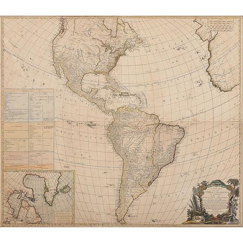
New Map of the Whole Continent of America, Divided Into North and South and West Indies, 1794
About Seller
6270 Este Ave.
Cincinnati , OH 45232
United States
With offices in Cincinnati, Cleveland and Denver, Cowan’s holds over 40 auctions each year, with annual sales exceeding $16M. We reach buyers around the globe, and take pride in our reputation for integrity, customer service and great results. A full-service house, Cowan’s Auctions specializes in Am...Read more
Two ways to bid:
- Leave a max absentee bid and the platform will bid on your behalf up to your maximum bid during the live auction.
- Bid live during the auction and your bids will be submitted real-time to the auctioneer.
Bid Increments
| Price | Bid Increment |
|---|---|
| $0 | $25 |
| $500 | $50 |
| $1,000 | $100 |
| $2,000 | $250 |
| $5,000 | $500 |
| $10,000 | $1,000 |
| $20,000 | $2,500 |
| $50,000 | $5,000 |
| $100,000 | $10,000 |
About Auction
Jun 9, 2017 - Jun 10, 2017
Cowan's Auctions dawnie@cowans.com
- Lot Description
D'Anville, Jean Baptiste Bourguignon (1697-1782). A New Map of the Whole Continent of America, Divided into North and South and West Indies wherein are exactly Described the United States of North America as well as The Several European Possessions according to the Preliminaries of Peace signed at Versailles, Jan. 20, 1783. Compiled from Mr. D'Anville's Maps of that Continent with the addition of the Spanish Discoveries in 1773 to the North of California & Corrected in the several Parts belonging to Great Britain from the Original Materials of Governor Pownall, MP. London: Published by Laurie & Whittle, 1794. Two sheets, copper plate engraving; overall size approx. 40.5 x 47 in. Hand-colored, with elaborate title cartouche lower right depicting many different exotic New World plants, some twined around acanthus leaf and scrollwork "frame," with alligator at bottom and what may be a beaver in background. Waterfalls lower left, a feather headdress to the left of them. Insert lower left: The supplement to North America containing the countries adjoining to Baffins & Hudsons Bays. Above that is a chart of the European nations and their colonial claims in the New World. D'Anville is recognized as one of the best scientific mapmakers of the 18th century, although this version of the map was published after his death. An earlier version appeared in 1772, with a Paris treaty date of February 10, 1763; one with the same January date as this was published by Robert Sayer in 1786 (both held by LOC).
"California" appears to apply only to the Baja peninsula. What we know today as California is labeled "New Albion." West of the Mississippi has sweeping labels for Louisiana, New Mexico and New Navarre with no real boundaries. This version includes details of the Pacific Northwest defined by Captain George Vancouver in his explorations.
Thomas Pownall was a Colonial Governor of Massachusetts Bay from 1757-1760. After his return to England, he served in the British Parliament.
Old folds; a few light water stains. Not removed from frame for examination. Has plexi or other non-glass protection to reduce weight.Condition
- Shipping Info
-
SHIPPING. At the request of the buyer, Cowan's will authorize the shipment of purchased items. Shipments usually occur within two weeks after payment has been received. Shipment is generally made via UPS Ground service. Unless buyer gives special instructions, the shipping method shall be at the sole discretion of Cowan's Auctions, Inc.. Cowan's is in no way responsible for the acts or omissions of independent handlers, packers or shippers of purchased items or for any loss, damage or delay from the packing or shipping of any property.
-
- Buyer's Premium


 EUR
EUR CAD
CAD AUD
AUD GBP
GBP MXN
MXN HKD
HKD CNY
CNY MYR
MYR SEK
SEK SGD
SGD CHF
CHF THB
THB


