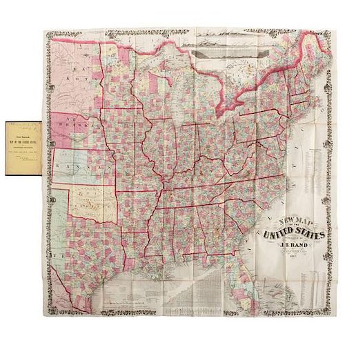
J.B. Rand, Pocket Map of the United States
About Seller
6270 Este Ave.
Cincinnati , OH 45232
United States
With offices in Cincinnati, Cleveland and Denver, Cowan’s holds over 40 auctions each year, with annual sales exceeding $16M. We reach buyers around the globe, and take pride in our reputation for integrity, customer service and great results. A full-service house, Cowan’s Auctions specializes in Am...Read more
Two ways to bid:
- Leave a max absentee bid and the platform will bid on your behalf up to your maximum bid during the live auction.
- Bid live during the auction and your bids will be submitted real-time to the auctioneer.
Bid Increments
| Price | Bid Increment |
|---|---|
| $0 | $25 |
| $500 | $50 |
| $1,000 | $100 |
| $2,000 | $250 |
| $5,000 | $500 |
| $10,000 | $1,000 |
| $20,000 | $2,500 |
| $50,000 | $5,000 |
| $100,000 | $10,000 |
About Auction
Jun 12, 2015 - Jun 13, 2015
Cowan's Auctions dawnie@cowans.com
- Lot Description
Lloyd, H.H. New Map of the United States. Published by J.B. Rand, Concord, N.H., 1867. 32.5 x 33.5 in. in 4 x 6 in. brown cloth folder with gilt title. Printed by F. Bourquin, Philadelphia. This extremely rare pocket map dates from just after the Civil War and documents the more occupied parts of the United States. For each, it illustrates counties, hand-colored in green, yellow, blue, pink. States are outlined in red. It does not cover California and other areas recently part of Mexico. In the states west of the Mississippi (Nebraska, Kansas, Texas), only the eastern half shows counties. The entire map is bordered by vines of oak leaves and acorns with small vignettes approx. every 6 inches or so. Along the right and top, the vignettes are a plow in front of a haystack (probably representing farming). The ones along the top are sideways, as if this is a strip applied to the side of the master map. This is reinforced by the vignettes along the left (and a couple at bottom) that are a cornucopia in the foreground with a large building (warehouse?) in the background and a "forest" of ship masts visible to the left (probably representing commerce). The ones on the left are upside-down. There are breaks in the border where it encounters various chart insets.
At the top are three profiles: Elevation of the route proposed by Lieut. Whipple for the Pacific railroad; elevation profile for the U.S. from Atlantic to Pacific at 42o N. latitude; and a profile (undersea) of the telegraphic plateau, from Newfoundland to Valentia (Island, Ireland). [42o N. latitude runs from about Cape Cod along the Pennsylvania-New York border across the plains to the Idaho and Oregon borders with Utah, Nevada and California.] There is a table of areas and populations for each state; a table of distances between cities ("Air-Line" miles, or today, distances "as the crow flies"); plus a short table of wars ("Old French War" - 11 years), Revolution, War of 1812, Mexican and "The Great Southern Rebellion."
Little is known of J.B. Rand. The only J. Rand we found in the Concord, NH City Directory of 1867 was Jacob B. at Court, near Summer (streets). In 1881 (city directory) a J.B. Rand at 11 Court St. is a Real Estate Agent. Note: This is not the Rand of Rand-McNally, the latter being a Chicago-based full-time cartographic business. According to an advertising leaflet that has surfaced, J.B. Rand appears to have published books of the 1860 and 1870 Censuses, and seems to have prepared patent papers, made engravings of machines, and maps for "traveling men" (salesmen). Other City Directories show a J.B. Rand as a machinist or maker of piano hardware. We also found a J.B. Rand as a co-patentee for several items in the early 1870s along with Horace Call. One patent under Rand alone is for "Composition for Welding Iron and Steel" (87,968 in 1871). Generally, a "jack of many trades," if not all trades.Colors still bright. A few short separations at folds. Scattered light foxing. Overall very good condition. There is a previous owner's name inside folder and a "cartoon" on the back of one folded panel, both in pencil and likely done by a child. Can probably be cleaned.Condition
- Shipping Info
-
SHIPPING. At the request of the buyer, Cowan's will authorize the shipment of purchased items. Shipments usually occur within two weeks after payment has been received. Shipment is generally made via UPS Ground service. Unless buyer gives special instructions, the shipping method shall be at the sole discretion of Cowan's Auctions, Inc.. Cowan's is in no way responsible for the acts or omissions of independent handlers, packers or shippers of purchased items or for any loss, damage or delay from the packing or shipping of any property.
-
- Buyer's Premium


 EUR
EUR CAD
CAD AUD
AUD GBP
GBP MXN
MXN HKD
HKD CNY
CNY MYR
MYR SEK
SEK SGD
SGD CHF
CHF THB
THB


