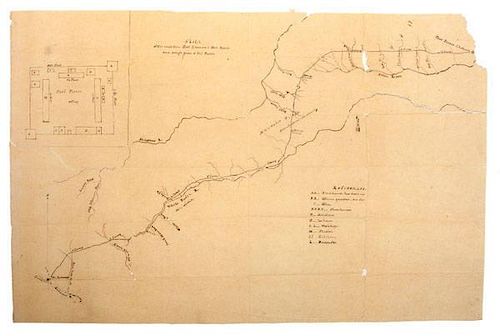
Fort Laramie - Fort Pierre Trail, Hand-Drawn Map, Ca 1855
About Seller
6270 Este Ave.
Cincinnati , OH 45232
United States
With offices in Cincinnati, Cleveland and Denver, Cowan’s holds over 40 auctions each year, with annual sales exceeding $16M. We reach buyers around the globe, and take pride in our reputation for integrity, customer service and great results. A full-service house, Cowan’s Auctions specializes in Am...Read more
Two ways to bid:
- Leave a max absentee bid and the platform will bid on your behalf up to your maximum bid during the live auction.
- Bid live during the auction and your bids will be submitted real-time to the auctioneer.
Bid Increments
| Price | Bid Increment |
|---|---|
| $0 | $25 |
| $500 | $50 |
| $1,000 | $100 |
| $2,000 | $250 |
| $5,000 | $500 |
| $10,000 | $1,000 |
| $20,000 | $2,500 |
| $50,000 | $5,000 |
| $100,000 | $10,000 |
About Auction
Jun 12, 2015 - Jun 13, 2015
Cowan's Auctions dawnie@cowans.com
- Lot Description
Hand-drawn map, 18.5 x 28 in., of the Fort Pierre-Fort Laramie Trail and "draft" of Fort Pierre. Believed to have been drawn at or before 1855 (when the U.S. Army first purchased the fort and began constructing more buildings than that shown in the sketch). During its peak, the Fort Pierre-Fort Laramie Trail carried approx. 125 tons of trade goods to the Indians, who delivered 250,000 buffalo robes, and lesser amounts of beaver, wolf, elk, antelope, and deer skins.
Fort Pierre [Chouteau] was built in 1832 and served as a trading post by John Jacob Astor’s American Fur Company (AFC). It became the largest and busiest fur trading post on the Upper MO River. During a quarter century it served as the post where bison robes (provided by the Yankton, Sioux, Santee, and Teton tribes) were exchanged for manufactured goods provided by the AFC. In 1849 the AFC went out of business. The fort was remodeled in 1850. It is possible that the fort pictured here is a proposal for the 1850 remodeled fort drawn in 1855, given that the trail itself was not mapped out until 1855. In 1855 the fort was purchased by the US Army for $45,000, and became the first military fort in the Upper Missouri. This same year Lt. (later Civil War General of Gettysburg notoriety) Gouverner K. Warren and Captain Parmenas T. Turnley make two separate sketches of Fort Pierre.* Warren also sketches out a trail from Fort Laramie to Fort Pierre. The Army made numerous repairs and built additional buildings outside the picketed enclosure. In 1856 a treaty council between General Harney and various Sioux tribes is conducted at the fort. In 1857 the Army abandoned Fort Pierre and all usable buildings are transported to Fort Randall. In 1868 the Laramie Treaty cedes to the Sioux Nation land that encompasses old Fort Pierre. The Sioux reservation was downsized in the late 1880s and the land underlying the fort fell outside the reservation. It was claimed by James “Scotty” Philips who is largely credited with saving the buffalo from extinction by breeding them on his ranch, which covered old Fort Pierre. Today, the site is owned by the South Dakota State Historical Society and excavations are underway. [* This map probably predates Kemble’s sketch because his sketch of the fort had 90 structures. We have not seen Turnley’s sketch to compare].
Fort Laramie was a significant 19th century trading post located at the confluence of the Laramie River and the North Platte River in Wyoming. Founded in the 1830s as Fort William, its primary purpose was to service the overland fur trade during the middle 19th century. In 1841 it was purchased by the AFC and renamed “Fort John at the Laramie River.” The fort was purchased from the AFC by the U.S. Army in 1849 to protect and supply emigrants along the emigrant trails. By this time common usage referred to the fort as “Fort Laramie.” In the late 1860s, the fort was the primary staging ground for the U.S. Army in the Powder River Country during Red Cloud's War. During the Great Sioux War of 1876-77 (which saw Custer’s demise) the fort served as a major staging point for supplies and troops. After the completion of the transcontinental railroad, the fort's importance decreased and the fort was decommissioned in 1890.
Fort Pierre- Fort Laramie Trail- From about 1837 until 1850, more than a quarter million buffalo robes bought from Indians and 27 tons of fur company trade goods were hauled over the 300 mile long Fort Pierre-Fort Laramie Trail that followed the White River through this area. First used by the AFC, the trail had its origin as part of an earlier Spanish trade route from Santa Fe to the Missouri River in present South Dakota. During the 1840s the Fort Pierre-Fort Laramie Trail was the shortest overland connection between trading posts on the Platte and steamboats on the Missouri River. After the government purchased Fort Laramie in 1849, Colonel Aeneas Mackay and Captain Stewart Van Vliet and 10 mounted riflemen traveled the trail to Fort Pierre. General William S. Harney's troops marched over the route in 1855, and the trail was mapped by Lt. G. K. Warren of his staff. Small traders and government freighters continued to use portions of the trail until the 1880s.
Besides a draft of the fort as an inset at the upper left, the trail between Fort Pierre and Fort Laramie also indicates the various encampments on the trail, with names. As surmised above, the sketch is unsigned and we do not know if this sketch was drawn by Lt. Warren, Parmenas T. Turnley, or some other person, but indications suggest that it was done at or prior to 1855.Ink erosion has caused some minor loss to the map at the upper right corner, not affecting any text. Nevertheless, a wonderful, scarce item.Condition
- Shipping Info
-
SHIPPING. At the request of the buyer, Cowan's will authorize the shipment of purchased items. Shipments usually occur within two weeks after payment has been received. Shipment is generally made via UPS Ground service. Unless buyer gives special instructions, the shipping method shall be at the sole discretion of Cowan's Auctions, Inc.. Cowan's is in no way responsible for the acts or omissions of independent handlers, packers or shippers of purchased items or for any loss, damage or delay from the packing or shipping of any property.
-
- Buyer's Premium


 EUR
EUR CAD
CAD AUD
AUD GBP
GBP MXN
MXN HKD
HKD CNY
CNY MYR
MYR SEK
SEK SGD
SGD CHF
CHF THB
THB


