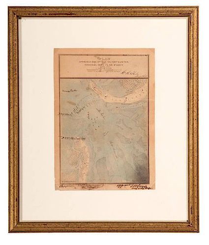
Charleston Harbor, Civil War-Date Map Owned by Confederate Engineer Col. David B. Harris, Plus
About Seller
6270 Este Ave.
Cincinnati , OH 45232
United States
With offices in Cincinnati, Cleveland and Denver, Cowan’s holds over 40 auctions each year, with annual sales exceeding $16M. We reach buyers around the globe, and take pride in our reputation for integrity, customer service and great results. A full-service house, Cowan’s Auctions specializes in Am...Read more
Two ways to bid:
- Leave a max absentee bid and the platform will bid on your behalf up to your maximum bid during the live auction.
- Bid live during the auction and your bids will be submitted real-time to the auctioneer.
Bid Increments
| Price | Bid Increment |
|---|---|
| $0 | $25 |
| $500 | $50 |
| $1,000 | $100 |
| $2,000 | $250 |
| $5,000 | $500 |
| $10,000 | $1,000 |
| $20,000 | $2,500 |
| $50,000 | $5,000 |
| $100,000 | $10,000 |
About Auction
Nov 21, 2014 - Nov 22, 2014
Cowan's Auctions dawnie@cowans.com
- Lot Description
Charleston Harbor, Civil War-Date Map Owned by Confederate Engineer Col. David B. Harris, Plus
Lot of 2, featuring a hand-tinted map of Charleston Harbor accompanied by a hand-tinted albumen print of the Confederate Major of Engineers, D.B. Harris, who owned and signed the map. The photo, by Cook, measures approx. 7 x 9 in., housed in period frame, 15 x 17 in.
The map, entitled Plan of the Approach and Attack on Ft. Sumter by the Federal Iron Clad Fleet, 7 April, 1863, is ink signed in the bottom margin, Approved G.T. Beauregard, Genl. Comdg., and Approved D.B. Harris, Maj. & Chief Engineer. With Wm. A. Walker, C.S. Eng. Corps. printed at bottom left corner of map. At top, beneath the title is printed, Drawn to Accompany Engineer Report, and ink signed, Wm. H. Echols, Major Engs. The map itself measures 6 x 10.25 in., and has been annotated with a number of hand-written names: Inner Harbor/ Outer Harbor/ Ship Channel/ Battery Gregg - 3 7/8 miles to C. [Charleston] (written beside Fort Sumter).
Beside each Confederate Fort or Battery, which are named Bee, Fort Moultrie, Beauregard, Wagner, etc., there is a small, hand-tinted Confederate flag, and the water portion of the harbor is tinted blue. Eight tiny ships are printed on the map, with one labeled in ink Keokuk. The Federal Ironclad Keokuk was sunk and the Confederates salvaged its enormous Dahlgren cannon, which is now mounted at White Point Garden on the Battery. One ship labeled Ironsides has been added in ink. Between Sullivan's Island and Fort Sumter is printed Rope Obstructions, with Torpedoes written in as well. The detail of this small map is remarkable, and incredibly impressive when enlarged photographically (one enlargement included with lot).
David Bullock Harris (1814-1864) was born in Louisa County, VA. His father was a railroad President (Louisa Railroad, which became the Virginia Central). Harris graduated from the United States Military Academy and was an engineering instructor at the academy. By 1845, he had acquired “Woodville,” a Goochland County, VA plantation where he grew tobacco and where he resided at the outbreak of the Civil War.
Serving on the staff of Confederate General Philip St. George Cocke, he was engaged at the first battle of Bull Run on July 21, 1861. General P.G.T. Beauregard asked Harris to join his staff and Harris planned the defenses of Centreville, VA.
Harris was promoted to Captain in the Confederate Engineers in February of 1862, then to Major in October 1862, Lt. Colonel in May of 1863, and Colonel in October 1863. Besides Centreville, Harris planned the defenses of Fort Pillow, Island Number Ten, Vicksburg, and Charleston, SC. With Beauregard in Charleston, Harris worked constantly to improve the fortifications and these formidable defenses gave Charleston the distinction of being the longest besieged city in our history! Beauregard brought Harris to Petersburg in the summer of 1864 and he planned the defenses there…the second longest besieged city in our history! Going back to Charleston as Chief Engineer in the Department of South Carolina, he died of Yellow Fever on October 10, 1864. President Jefferson Davis had planned (verbally promised) a promotion to Brigadier General Just before Harris died. He is buried in Hollywood Cemetery in Richmond, VA.
While the map is dated April 7, 1863, we know that Harris must have signed it Approved very close to that date as he signs as Major. He would become Colonel in October.
Two exceptional pieces of Confederate and Charleston Naval history.Photo with some age spotting, but image and tinting remain bright, with stars on Harris collar vivid. Condition of map is good with some staining and age discoloration. Although the map shows folds, there is no separation along the folds. The map is not laid down, but is secured at each corner underneath plastic corner tabs.Condition
- Shipping Info
-
SHIPPING. At the request of the buyer, Cowan's will authorize the shipment of purchased items. Shipments usually occur within two weeks after payment has been received. Shipment is generally made via UPS Ground service. Unless buyer gives special instructions, the shipping method shall be at the sole discretion of Cowan's Auctions, Inc.. Cowan's is in no way responsible for the acts or omissions of independent handlers, packers or shippers of purchased items or for any loss, damage or delay from the packing or shipping of any property.
-
- Buyer's Premium


 EUR
EUR CAD
CAD AUD
AUD GBP
GBP MXN
MXN HKD
HKD CNY
CNY MYR
MYR SEK
SEK SGD
SGD CHF
CHF THB
THB


