An Analysis of the French and Indian War
About Seller
6270 Este Ave.
Cincinnati , OH 45232
United States
With offices in Cincinnati, Cleveland and Denver, Cowan’s holds over 40 auctions each year, with annual sales exceeding $16M. We reach buyers around the globe, and take pride in our reputation for integrity, customer service and great results. A full-service house, Cowan’s Auctions specializes in Am...Read more
Two ways to bid:
- Leave a max absentee bid and the platform will bid on your behalf up to your maximum bid during the live auction.
- Bid live during the auction and your bids will be submitted real-time to the auctioneer.
Bid Increments
| Price | Bid Increment |
|---|---|
| $0 | $25 |
| $500 | $50 |
| $1,000 | $100 |
| $2,000 | $250 |
| $5,000 | $500 |
| $10,000 | $1,000 |
| $20,000 | $2,500 |
| $50,000 | $5,000 |
| $100,000 | $10,000 |
About Auction
Nov 21, 2014 - Nov 22, 2014
Cowan's Auctions dawnie@cowans.com
- Lot Description
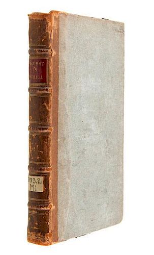
An Analysis of the French and Indian War
[Mitchell, Dr. John] The Contest in America Between Great Britain and France, with Its Consequences and Importance; Giving an Account of the Views and Designs of the French with the Interests of Great Britain, and the Situation of the British and French Colonies, in all Parts of America: in Which a Proper Barrier between the Two Nations in North America is Pointed out, with a Method to Prosecute the War so as to Obtain that Necessary Security for our Colonies. By an Impartial Hand. London: A. Millar, 1762. 12mo, half-leather over plain paper-covered boards, five spine bands, 244pp. [Howes M-676] Generally ascribed to Mitchell, but some also attribute it to Oliver Goldsmith. [Sabin 49693]
John Mitchell (1711 - 1768) was born to a wealthy Virginia family, and attended Edinburgh University in Scotland. Although he only completed two of the three years of the medical program there, when he returned to Virginia, he practiced as a physician. He also had a keen interest in the local botany. In 1746, ill health forced Mitchell and his wife to go to London, where he continued his interest in plants. Since gardening was a common hobby, he met many influential men of the day.
A couple years after his move to London, he was approached by the 2nd Earl of Halifax to make an up-to-date map of the colonies, and Halifax decided Mitchell was the expert on the colonies. As Mitchell pulled together what was known at the time in Europe, he realized it was inadequate. Halifax ordered the governors of the colonies to have new maps sent to England, which most seem to have done. Mitchell then fitted the maps together, and drafted a large - 6.5 x 4.5 foot map of North America. The map is so full of notes and commentaries (some accurate, some not) that reductions of the map made these unreadable.
Mitchell's map was published in 1755 by Andrew Millar, the same publisher as this volume. Could this anonymously written tome be Mitchell's thoughts on the situation in America during the French and Indian War? Some of the early speculations on why Mitchell made his famous map, which remained one of the most accurate for decades, and was used at the Treaty of Paris for defining the new nation at the end of the Revolution, was that he was concerned that the "powers that be" in London were ignoring the colonies and their problems. This turned out not to be the reason the map was constructed, but Mitchell might have been concerned about his fellow colonials nonetheless.
The text defies the notion that its author was "Impartial." After suggesting a number of potential improvements, the author notes: "But there is an obstruction to all these improvements in our colonies, especially in the northern colonies on the continent, where they are most wanted, that is insurmountable, and makes it impossible for them ever to attempt them in any general manner at least, so as to turn to any considerable account to this nation, so long as those colonies remain in the situation they are in at present, that is, by being surrounded on all sides by the French."Front hinge weakening. Shelfwear and lower corners bumped. Only very light occasional toning.Condition
- Shipping Info
-
SHIPPING. At the request of the buyer, Cowan's will authorize the shipment of purchased items. Shipments usually occur within two weeks after payment has been received. Shipment is generally made via UPS Ground service. Unless buyer gives special instructions, the shipping method shall be at the sole discretion of Cowan's Auctions, Inc.. Cowan's is in no way responsible for the acts or omissions of independent handlers, packers or shippers of purchased items or for any loss, damage or delay from the packing or shipping of any property.
-
- Buyer's Premium


 EUR
EUR CAD
CAD AUD
AUD GBP
GBP MXN
MXN HKD
HKD CNY
CNY MYR
MYR SEK
SEK SGD
SGD CHF
CHF THB
THB


