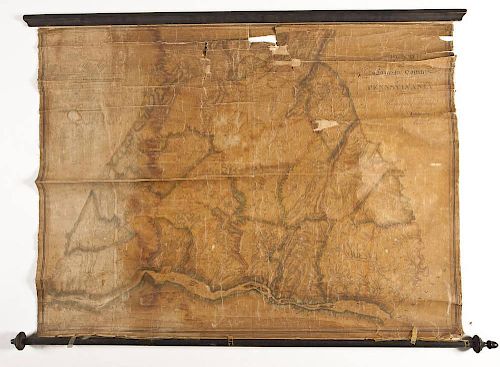
1824 Joshua Scott Map of Lancaster, PA
About Seller
1500 Paxton St
Harrisburg, PA 17104
United States
David and Sandra Cordier had been modest collectors when they began their business in 1980, while living in Halifax, Pennsylvania. Initially the Cordiers exhibited at area venues such as Black Angus near Reading, Pennsylvania, and the Eastern National Antiques Show held twice yearly in Harrisburg. T...Read more
Two ways to bid:
- Leave a max absentee bid and the platform will bid on your behalf up to your maximum bid during the live auction.
- Bid live during the auction and your bids will be submitted real-time to the auctioneer.
Bid Increments
| Price | Bid Increment |
|---|---|
| $0 | $10 |
| $200 | $25 |
| $500 | $50 |
| $1,000 | $100 |
| $5,000 | $500 |
| $10,000 | $1,000 |
| $50,000 | $5,000 |
| $100,000 | $10,000 |
About Auction
Nov 8, 2014 - Nov 9, 2014
Cordier Auctions & Appraisals info@cordierauction.com
- Lot Description
DESCRIPTION: 1824 Joshua Scott Map of Lancaster, Pennsylvania. With scale and statistical table which details inhabitants, taxables, acres of land, value of land per acre 1st rate, taverns, stores, and mills and manufactories. Printed in the upper right corner "Map of Lancaster County Pennsylvania. Respectfully Dedicated to the Inhabitants by Joshua Scott Lancaster, January 1st 1824". On wood rod, rolls. Wall map. MEASUREMENTS: 38-1/2" x 54-1/2". CONDITION: Deep toning throughout, breaking to paper, tears, holes. Areas previously repaired with tape.
- Shipping Info
-
Shipping provided by:The UPS Store717-731-0555store0698@theupsstore.comPlease contact them directly for pre-auction shipping quotes.
-
- Buyer's Premium


 EUR
EUR CAD
CAD AUD
AUD GBP
GBP MXN
MXN HKD
HKD CNY
CNY MYR
MYR SEK
SEK SGD
SGD CHF
CHF THB
THB


