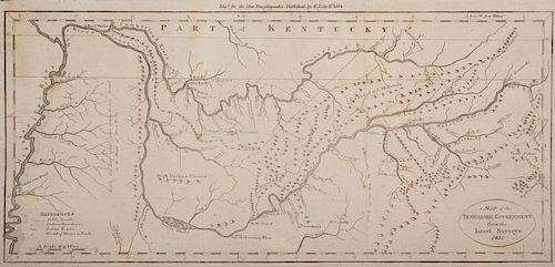
Tenn. Map 1811, Payne/Low
Lot 209
About Seller
Case Auctions
4310 Papermill Dr. NW
Knoxville, TN 37909
United States
Case Auctions is based in Knoxville, Tennessee, where our gallery is located, with satellite offices in Nashville, Tennessee and Kingsport, TN – but our reach is worldwide. Established in 2005, we conduct cataloged auctions of investment-quality art and antiques under the stewardship of knowledgeabl...Read more
Categories
Estimate:
$500 - $700
Absentee vs Live bid
Two ways to bid:
- Leave a max absentee bid and the platform will bid on your behalf up to your maximum bid during the live auction.
- Bid live during the auction and your bids will be submitted real-time to the auctioneer.
Bid Increments
| Price | Bid Increment |
|---|---|
| $0 | $10 |
| $100 | $25 |
| $500 | $50 |
| $1,000 | $100 |
| $3,000 | $200 |
| $5,000 | $500 |
| $10,000 | $1,000 |
| $20,000 | $2,000 |
| $50,000 | $5,000 |
| $100,000 | $10,000 |
About Auction
By Case Auctions
Jan 21, 2017 - Jan 22, 2017
Set Reminder
2017-01-21 09:00:00
2017-01-22 09:00:00
America/New_York
Bidsquare
Bidsquare : Winter Fine Art and Antiques Auction
https://www.bidsquare.com/auctions/case-antiques/winter-fine-art-and-antiques-auction-2050
Case Auctions bid@caseantiques.com
Case Auctions bid@caseantiques.com
- Lot Description
"A Map of the Tennassee [sic] Government from the latest Surveys 1810", by John Payne, published by E. Low, New York, 1811. From "A New and Complete Universal Geography", Vol. IV, by John Payne. Copper plate engraving of early Tennessee depicting early towns and roads, including Knoxville, Nashville, and "Clerksville" (Clarksville), Native American towns and roads, boundary lines, rivers, mountain ranges, and remarks about the land including the inscription "Light Soil Long Grass. Little Timber. Broken Ground. on the Heads of these Rivers." vertical across the area of Western Tennessee. Title, lower right, references and scale of miles, lower left. "Long. W. from Philada." top right above map. Map surrounded by scale notations and line border. Image - 6 7/8" H x 15" W. Sheet - 10" H x 16" W. Early 19th century. Provenance: Collection of Charles and Ann Wells, Nashville, Tennessee. (Higher-resolution photos are available at www.caseantiques.com)Areas of toning, largest 4" top left, on surface of sheet. Toning impression of text page visible on left side of sheet. Black scuffs, top left corner of plate impression. Tears, largest 1/4", lower right edge of sheet. Areas of toning, toning impression of text page, visible en verso.
Condition
- Shipping Info
-
Buyer Pays Shipping Cost – Buyers are responsible for making shipping arrangements through our recommended shippers or a shipper of their choice. For shipping estimates, contact these shippers with the lot number(s) or a shipper of your choice. Our recommended shippers follow:
- Package Manager of Knoxville, 865-584-3000, info@packagemanager.net (The Manager is Gwynn)
- The UPS Store of Northshore Knoxville, 865-951-2499, store6461@theupsstore.com (The Manager is Jonathan)
- The UPS Store of Lenoir City, 865-988-5526, auction4526@theupsstore.com (The Manager is John)
- The UPS Store of Downtown Knoxville, 865-584-0081, store2630@theupsstore.com (The Manager is Nathan).
-
- Buyer's Premium


 EUR
EUR CAD
CAD AUD
AUD GBP
GBP MXN
MXN HKD
HKD CNY
CNY MYR
MYR SEK
SEK SGD
SGD CHF
CHF THB
THB


