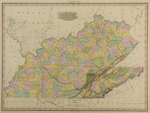
KY and TN 1823 Map, H.S. Tanner
Lot 212
About Seller
Case Auctions
4310 Papermill Dr. NW
Knoxville, TN 37909
United States
Case Auctions is based in Knoxville, Tennessee, where our gallery is located, with satellite offices in Nashville, Tennessee and Kingsport, TN – but our reach is worldwide. Established in 2005, we conduct cataloged auctions of investment-quality art and antiques under the stewardship of knowledgeabl...Read more
Categories
Estimate:
$700 - $900
Absentee vs Live bid
Two ways to bid:
- Leave a max absentee bid and the platform will bid on your behalf up to your maximum bid during the live auction.
- Bid live during the auction and your bids will be submitted real-time to the auctioneer.
Bid Increments
| Price | Bid Increment |
|---|---|
| $0 | $10 |
| $100 | $25 |
| $500 | $50 |
| $1,000 | $100 |
| $3,000 | $200 |
| $5,000 | $500 |
| $10,000 | $1,000 |
| $20,000 | $2,000 |
| $50,000 | $5,000 |
| $100,000 | $10,000 |
About Auction
By Case Auctions
Jan 21, 2017 - Jan 22, 2017
Set Reminder
2017-01-21 09:00:00
2017-01-22 09:00:00
America/New_York
Bidsquare
Bidsquare : Winter Fine Art and Antiques Auction
https://www.bidsquare.com/auctions/case-antiques/winter-fine-art-and-antiques-auction-2050
Case Auctions bid@caseantiques.com
Case Auctions bid@caseantiques.com
- Lot Description
Map of Kentucky and Tennessee, engraved by Henry S. Tanner and Assistants, published by Henry S. Tanner, Philadelphia, 1823. From "A New American Atlas " by Henry S. Tanner. Copper plate engraving with hand coloring of Kentucky and Tennessee depicting towns, roads, county lines, names of counties, rivers, mountains, and railroads. Points of interest include a notation on the location of the Cherokee, lower right of Tennessee, and the boundaries of the yet to be founded Fayette County, lower left of Tennessee. Title, top center of map, scales of miles and explanation, lower center of map. "Longitude West from Washington", centered above map, "Longitude West from Greenwich", centered below map. Map surrounded by scale notations and triple line border. Housed in a contemporary wooden frame. Image - 21 1/4" H x 28 1/8" W. Sight - 22 3/4" H x 29 1/2" W. Framed - 29 1/2" H x 37" W. American, early 19th century. Provenance: Collection of Charles and Ann Wells, Nashville, Tennessee. (Higher-resolution photos are available at www.caseantiques.com)Toning impression of map, visible on surface of sheet. Minute foxing spots, scattered on surface of sheet. Not examined out of frame.
Condition
- Shipping Info
-
Buyer Pays Shipping Cost – Buyers are responsible for making shipping arrangements through our recommended shippers or a shipper of their choice. For shipping estimates, contact these shippers with the lot number(s) or a shipper of your choice. Our recommended shippers follow:
- Package Manager of Knoxville, 865-584-3000, info@packagemanager.net (The Manager is Gwynn)
- The UPS Store of Northshore Knoxville, 865-951-2499, store6461@theupsstore.com (The Manager is Jonathan)
- The UPS Store of Lenoir City, 865-988-5526, auction4526@theupsstore.com (The Manager is John)
- The UPS Store of Downtown Knoxville, 865-584-0081, store2630@theupsstore.com (The Manager is Nathan).
-
- Buyer's Premium


 EUR
EUR CAD
CAD AUD
AUD GBP
GBP MXN
MXN HKD
HKD CNY
CNY MYR
MYR SEK
SEK SGD
SGD CHF
CHF THB
THB


