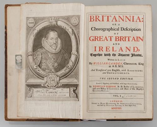
Britannia, Vol. I & II Camden 1722
Lot 549
About Seller
Case Auctions
4310 Papermill Dr. NW
Knoxville, TN 37909
United States
Case Auctions is based in Knoxville, Tennessee, where our gallery is located, with satellite offices in Nashville, Tennessee and Kingsport, TN – but our reach is worldwide. Established in 2005, we conduct cataloged auctions of investment-quality art and antiques under the stewardship of knowledgeabl...Read more
Categories
Estimate:
$600 - $800
Absentee vs Live bid
Two ways to bid:
- Leave a max absentee bid and the platform will bid on your behalf up to your maximum bid during the live auction.
- Bid live during the auction and your bids will be submitted real-time to the auctioneer.
Bid Increments
| Price | Bid Increment |
|---|---|
| $0 | $10 |
| $100 | $25 |
| $500 | $50 |
| $1,000 | $100 |
| $3,000 | $200 |
| $5,000 | $500 |
| $10,000 | $1,000 |
| $20,000 | $2,000 |
| $50,000 | $5,000 |
| $100,000 | $10,000 |
About Auction
By Case Auctions
Jan 21, 2017 - Jan 22, 2017
Set Reminder
2017-01-21 09:00:00
2017-01-22 09:00:00
America/New_York
Bidsquare
Bidsquare : Winter Fine Art and Antiques Auction
https://www.bidsquare.com/auctions/case-antiques/winter-fine-art-and-antiques-auction-2050
Case Auctions bid@caseantiques.com
Case Auctions bid@caseantiques.com
- Lot Description
Camden, William. Revised by Edmund Gibson. Britannia: Or a Chorographical Description of Great Britain and Ireland, Together with the Adjacent Islands. The Second Edition, Revised, Digested, and Published, Published with Large Additions and Improvements by Edmund Gibson. London: Printed by Mary Matthews, for Awnsham Churchill, and Sold by William Taylor, 1722. 2 Volumes: complete in two tall folio volumes, most pages printed in two numbered columns: Vol. one: [66]pp, cclxviii columns,[2]pp, 696 columns; Vol. two: [2], 697-1526 columns,[176, appendices, index and errata]pp. Hard cover brown leather with tooling on covers, six raised hubs and faded gilt lettering on spine. Inscribed "F. Tasburgh" on title page of both volumes. Folio. 16" H x 10 1/2" W x 2 1/2" D. Map/Plate Collation: [map] England by Robert Morden, [map] Britannia Romana, [plate] British Coins, [plate] British Coins, [plate] Roman Coins, [plate] Roman Coins, [map] Britannia Saxonica, [5 plates] Saxon Coins, Counties of England and Wales, [map] Cornwall, [map] Devonshire (slight worm damage), [map] Dorset Shire, [map] Somerset Shire' [map] Wiltshire by, [map] Hampshire, [map] Barkshire, [map] Surrey [map] Sussex, [foldout map] Kent approx. 25 _î by 15 _î, [map] Gloucestershire, [map] Oxfordshire, [map] Buckinghamshire, [map] Devonshire, [map] Bedfordshire, [map] Hertfordshire, [map] Middlesex, [map] Essex two inch closed tear barely entering map), [map] Suffolk, [foldout map] Norfolk, [map] Cambridgeshire, [map] Huntingtonshire, [map] Northhamptonshire, [map] Leicestershire, [map] Rotelandiae (Rutlandshire), [map] Lincolnshire, [map] Nottingsham shire, [map] Darbyshire, [map] Warwickshire, [map] Worcestshire, [map] Staffordshire, [map] Shropshire, [map] County Palatine of Chester, [map] Herefordshire, 36 maps 9 plates of coins, End of Volume One. [map] South Wales, [map] County of Monmouth, [map] New and Correct Map of North-Wales, [plate] Curiosities, [map] West Riding of Yorkshire, [map] East Riding of Yorkshire' [map] North Riding of Yorkshire, [map] Dunelmensisò Durham, [map] County Palatine of Lancaster, [map] Westmorland, [map] Cumberland, [map] Northumberland, [map] South Part of Scotland (slight loss to trimming), [map] North Part of Scotland (slight loss to trimming), [map] Kingdom of Ireland, [map] Smaller Islands in the British Ocean, 15 maps 1 plate. Provenance: Private Knoxville, TN collection. (Higher-resolution photos are available at www.caseantiques.com)Rebacked with new corners in leather. Original boards retained. Leather rubbed with some cracking at hinges. Text in good condition with just slight foxing and toning. Completely collated and all maps and plates in very good condition with very little offsetting.
Condition
- Shipping Info
-
Buyer Pays Shipping Cost – Buyers are responsible for making shipping arrangements through our recommended shippers or a shipper of their choice. For shipping estimates, contact these shippers with the lot number(s) or a shipper of your choice. Our recommended shippers follow:
- Package Manager of Knoxville, 865-584-3000, info@packagemanager.net (The Manager is Gwynn)
- The UPS Store of Northshore Knoxville, 865-951-2499, store6461@theupsstore.com (The Manager is Jonathan)
- The UPS Store of Lenoir City, 865-988-5526, auction4526@theupsstore.com (The Manager is John)
- The UPS Store of Downtown Knoxville, 865-584-0081, store2630@theupsstore.com (The Manager is Nathan).
-
- Buyer's Premium


 EUR
EUR CAD
CAD AUD
AUD GBP
GBP MXN
MXN HKD
HKD CNY
CNY MYR
MYR SEK
SEK SGD
SGD CHF
CHF THB
THB


