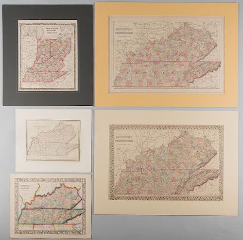
5 Kentucky and Tennessee Maps
Lot 213
About Seller
Case Auctions
4310 Papermill Dr. NW
Knoxville, TN 37909
United States
Case Auctions is based in Knoxville, Tennessee, where our gallery is located, with satellite offices in Nashville, Tennessee and Kingsport, TN – but our reach is worldwide. Established in 2005, we conduct cataloged auctions of investment-quality art and antiques under the stewardship of knowledgeabl...Read more
Categories
Estimate:
$500 - $600
Absentee vs Live bid
Two ways to bid:
- Leave a max absentee bid and the platform will bid on your behalf up to your maximum bid during the live auction.
- Bid live during the auction and your bids will be submitted real-time to the auctioneer.
Bid Increments
| Price | Bid Increment |
|---|---|
| $0 | $10 |
| $100 | $25 |
| $500 | $50 |
| $1,000 | $100 |
| $3,000 | $200 |
| $5,000 | $500 |
| $10,000 | $1,000 |
| $20,000 | $2,000 |
| $50,000 | $5,000 |
| $100,000 | $10,000 |
About Auction
By Case Auctions
Jan 21, 2017 - Jan 22, 2017
Set Reminder
2017-01-21 09:00:00
2017-01-22 09:00:00
America/New_York
Bidsquare
Bidsquare : Winter Fine Art and Antiques Auction
https://www.bidsquare.com/auctions/case-antiques/winter-fine-art-and-antiques-auction-2050
Case Auctions bid@caseantiques.com
Case Auctions bid@caseantiques.com
- Lot Description
1st item: "Tennessee & Kentucky" Map, by Thomas G. Bradford, engraved by George W. Boynton, published by William D. Ticknor, Boston, 1835. From "A Comprehensive Atlas, Geographical, Historical & Commercial" by Thomas G. Bradford. Copper plate engraving with hand colored outlines of Tennessee and Kentucky depicting towns and roads, county lines, names of counties, rivers, mountains, and a notation on the location of the "Cherokee Indians", lower right of state of Tennessee. Title and explanation, top left. Scale of miles, lower right. "Longitude West from Washington", centered below map, "Longitude West from London", centered below map. Map surrounded by scale notations and triple line border. Mounted to matte. Image - 7 3/4" H x 10" W. Sheet - 9 7/8" H x 13" W. Matte - 12" H x 14 1/4" W. 2nd item: "County Map of Kentucky and Tennessee", by Samuel Augustus Mitchell, Jr., 1865. From "Mitchell's New General Atlas" by Samuel Augustus Mitchell, Jr. Steel plate engraving with hand coloring of Kentucky and Tennessee depicting towns and roads, county lines, names of counties, rivers, and mountains. Title and scale of miles, top left. "Longitude West from Greenwich", centered above map, "Longitude West from Washington", centered below map. Map surrounded by scale notations and decorative border. Image - 10 5/8" H x 13 3/8" W. Sheet - 12 1/4" H x 15 1/4" W. 3rd item: "Ohio, Indiana, Kentucky, and Tennessee" Map, by George W. Colton, published by Joseph H. Colton, New York, 1859. From "Colton's Illustrated Cabinet Atlas and Descriptive Geography Maps" by Richard S. Fisher. Steel plate engraving with hand coloring of Ohio, Indiana, Kentucky, and Tennessee depicting towns and roads, county lines, names of counties, rivers, and mountains. Includes inset map of the "Vicinity of Cincinnati", top left. Title, top center, explanation and scale of miles, lower right. Map surrounded by scale notations and decorative border. Mounted to matte. Image - 12 5/8" H x 10 5/8" W. Sheet - 14 5/8" H x 11 7/8" W. Matte - 19 3/8" H x 17" W. 4th item: "County Map of Kentucky and Tennessee" by Samuel Augustus Mitchell, Jr., drawn and engraved by William H. Gamble, published by William M. Bradley and Brother, Philadelphia, 1886. From "Mitchell's New General Atlas" by Samuel Augustus Mitchell, Jr. Steel plate engraving with hand coloring of Kentucky and Tennessee depicting towns and roads, county lines, names of counties, rivers, and mountains. Title and scale of miles, top left. "Longitude West from Greenwich", centered above map, "Longitude West from Washington", centered below map. Map surrounded by scale notations and double line border. Mounted to matte. Image ì 14 1/2" H x 21 3/8" W. Sheet ì 15 1/4" H x 23 1/8" W. Matte - 20" H x 27" W. 5th item: "County Map of Kentucky and Tennessee" by Samuel Augustus Mitchell, Jr., drawn and engraved by William H. Gamble, published by S. Mitchell, Philadelphia, 1882. From "Mitchell's New General Atlas" by Samuel Augustus Mitchell, Jr. Steel plate engraving with hand coloring of Kentucky and Tennessee depicting towns and roads, county lines, names of counties, rivers, and mountains. Title and scale of miles, top left. "Longitude West from Greenwich", centered above map, "Longitude West from Washington", centered below map. Map surrounded by scale notations and grape vine border. Mounted to matte. Image ì 14 1/4" H x 21 1/4" W. Sheet ì 15 1/4" H x 23 1/4" W. Matte - 20" H x 27" W. All items mid/late 19th century. Provenance: Collection of Charles and Ann Wells, Nashville, Tennessee. (Higher-resolution photos are available at www.caseantiques.com)1st item: Green coloring on border extends onto sheet, lower right. Slight toning on edges of sheet. 2nd item: Blue coloring on outline extends onto sheet, lower right. Two tears on lower edge, largest 3/4" lower right. Scattered scuffs and marks on surface of sheet. Scattered scuffs and marks visible en verso. 3rd item: Foxing spots, largest 1/4", left edge of sheet. Slight toning around edges of sheet. Pinprick hole, centered below map. Foxing spots, pinprick hole visible en verso. 4th item: Pink coloring on outline extends onto sheet, lower left. Slight toning around edges of sheet. 5th item: Slight toning around edges of sheet. Paper torn, lower left corner. Black scuffs visible en verso.
Condition
- Shipping Info
-
Buyer Pays Shipping Cost – Buyers are responsible for making shipping arrangements through our recommended shippers or a shipper of their choice. For shipping estimates, contact these shippers with the lot number(s) or a shipper of your choice. Our recommended shippers follow:
- Package Manager of Knoxville, 865-584-3000, info@packagemanager.net (The Manager is Gwynn)
- The UPS Store of Northshore Knoxville, 865-951-2499, store6461@theupsstore.com (The Manager is Jonathan)
- The UPS Store of Lenoir City, 865-988-5526, auction4526@theupsstore.com (The Manager is John)
- The UPS Store of Downtown Knoxville, 865-584-0081, store2630@theupsstore.com (The Manager is Nathan).
-
- Buyer's Premium


 EUR
EUR CAD
CAD AUD
AUD GBP
GBP MXN
MXN HKD
HKD CNY
CNY MYR
MYR SEK
SEK SGD
SGD CHF
CHF THB
THB


