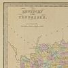
3 TN and KY maps inc. Bradford, Greenleaf, Illman
Lot 713
About Seller
Case Auctions
4310 Papermill Dr. NW
Knoxville, TN 37909
United States
Case Auctions is based in Knoxville, Tennessee, where our gallery is located, with satellite offices in Nashville, Tennessee and Kingsport, TN – but our reach is worldwide. Established in 2005, we conduct cataloged auctions of investment-quality art and antiques under the stewardship of knowledgeabl...Read more
Categories
Estimate:
$300 - $400
Absentee vs Live bid
Two ways to bid:
- Leave a max absentee bid and the platform will bid on your behalf up to your maximum bid during the live auction.
- Bid live during the auction and your bids will be submitted real-time to the auctioneer.
Bid Increments
| Price | Bid Increment |
|---|---|
| $0 | $10 |
| $100 | $25 |
| $500 | $50 |
| $1,000 | $100 |
| $3,000 | $200 |
| $5,000 | $500 |
| $10,000 | $1,000 |
| $20,000 | $2,000 |
| $50,000 | $5,000 |
| $100,000 | $10,000 |
About Auction
By Case Auctions
Jul 30, 2016 - Jul 31, 2016
Set Reminder
2016-07-30 09:00:00
2016-07-31 09:00:00
America/New_York
Bidsquare
Bidsquare : Historic Southern Summer Auction
https://www.bidsquare.com/auctions/case-antiques/historic-southern-summer-auction-1593
Case Auctions bid@caseantiques.com
Case Auctions bid@caseantiques.com
- Lot Description
Three (3) Maps, 1 of Tennessee, 2 of Kentucky and Tennessee. 1st item: "Tennessee" Map by Thomas G. Bradford and engraved by George W Boynton, 1838. Colored map of Tennessee divided by county, with cities, towns, rivers, mountain ranges, and train tracks. Uncolored areas of surrounding states included. Image - 11 1/2" H x 14 3/4" L. Sheet - 13 1/8" H x 16 1/4" L. 2nd item: "Kentucky and Tennessee" map by Jeremiah Greenleaf from his "A New Universal Atlas", 1848. Colored map of Kentucky and Tennessee divided by county, with cities, towns, rivers, mountain ranges, and train tracks. Uncolored areas of surrounding states included. Image - 10 3/4" H x 12 5/8" L. Sheet - 12" H x 14 1/2" L. 3rd item: "Kentucky and Tennessee" map by Thomas Illman after David H. Burr from his "A New Universal Atlas", 1834. Colored map of Kentucky and Tennessee with cities, towns, rivers, mountain ranges, and train tracks. Includes surrounding states colored in light yellow. Secured to piece of cardboard. Plate - 12" H x 14" L. Sheet - 12 3/8" H x 14 1/2" L. (Higher-resolution photos are available at www.caseantiques.com)1st item: Toning spots around edges, largest 1/2" top left. Slight toning around edges. Missing sections of paper, lower left and bottom right corner. 2nd item: Surface toning and spots, largest 1/4" top left. Slight toning and old water damage around edges. Old water damage visible en verso. Missing section of paper, top left corner. 3rd item: Few toning spots, largest 1/8" top middle left. Minor scuffs on surface, largest 3/8" bottom left.
Condition
- Shipping Info
-
Buyer Pays Shipping Cost – Buyers are responsible for making shipping arrangements through our recommended shippers or a shipper of their choice. For shipping estimates, contact these shippers with the lot number(s) or a shipper of your choice. Our recommended shippers follow:
- Package Manager of Knoxville, 865-584-3000, info@packagemanager.net (The Manager is Gwynn)
- The UPS Store of Northshore Knoxville, 865-951-2499, store6461@theupsstore.com (The Manager is Jonathan)
- The UPS Store of Lenoir City, 865-988-5526, auction4526@theupsstore.com (The Manager is John)
- The UPS Store of Downtown Knoxville, 865-584-0081, store2630@theupsstore.com (The Manager is Nathan).
-
- Buyer's Premium


 EUR
EUR CAD
CAD AUD
AUD GBP
GBP MXN
MXN HKD
HKD CNY
CNY MYR
MYR SEK
SEK SGD
SGD CHF
CHF THB
THB


![South Carolina Land Grant and Wax Seal, 1794 [Wm. Moultrie]](https://s1.img.bidsquare.com/item/m/2837/28370601.jpeg?t=1T93IV)
![South Carolina Land Grant and Wax Seal, 1794 [Wm. Moultrie]](https://s1.img.bidsquare.com/item/m/2837/28370602.jpeg?t=1T93IV)
![Revolutionary War Claim Signed by John C. Calhoun [for Van Rensselaer]](https://s1.img.bidsquare.com/item/m/2837/28370603.jpeg?t=1T93IV)


