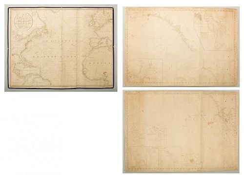
3 Nautical Maps inc. Southern 1861
Lot 542
About Seller
Case Auctions
4310 Papermill Dr. NW
Knoxville, TN 37909
United States
Case Auctions is based in Knoxville, Tennessee, where our gallery is located, with satellite offices in Nashville, Tennessee and Kingsport, TN – but our reach is worldwide. Established in 2005, we conduct cataloged auctions of investment-quality art and antiques under the stewardship of knowledgeabl...Read more
Categories
Estimate:
$400 - $500
Absentee vs Live bid
Two ways to bid:
- Leave a max absentee bid and the platform will bid on your behalf up to your maximum bid during the live auction.
- Bid live during the auction and your bids will be submitted real-time to the auctioneer.
Bid Increments
| Price | Bid Increment |
|---|---|
| $0 | $10 |
| $100 | $25 |
| $500 | $50 |
| $1,000 | $100 |
| $3,000 | $200 |
| $5,000 | $500 |
| $10,000 | $1,000 |
| $20,000 | $2,000 |
| $50,000 | $5,000 |
| $100,000 | $10,000 |
About Auction
By Case Auctions
Jan 21, 2017 - Jan 22, 2017
Set Reminder
2017-01-21 09:00:00
2017-01-22 09:00:00
America/New_York
Bidsquare
Bidsquare : Winter Fine Art and Antiques Auction
https://www.bidsquare.com/auctions/case-antiques/winter-fine-art-and-antiques-auction-2050
Case Auctions bid@caseantiques.com
Case Auctions bid@caseantiques.com
- Lot Description
1st item: Nautical Map: A New Chart of the Western or Atlantic Ocean, Drawn from the Best Authorities by J. S. Norie, printed London, 1831. Shows the coasts of the United States, Labrador and Eskmaux rather than Canada, South America, Africa, Spain, England and Ireland. The Azores, Cape Verde Islands, and other islands are also shown. 39 1/4" x 51". Original blueback paper with canvas edging. J. Grant Navigation Warehouse label en verso. 2nd item: Civil War era nautical map showing the Core Banks of North Carolina's coast: Cape Fear, Cape Lookout, Cape Hatteras, along with insets of Beaufort Harbour, Hatteras Shoals, and the Bar and Roads of Occracock. Various pencil markings chart a voyage of July, 1861. Published by E. and G.W. Blunt, New York, undated. Original blue backing with canvas edging. 38" x 27". 3rd item: Nautical map of the Harbor of Charleston, South Carolina, Reduced from the original survey of Major H. Bache, U.S.T.E., Engraved by William Hooker, New York. Published by E. and G.W. Blunt, undated. Shows the coastline of Florida, Georgia, South Carolina and North Carolina, with large upper right corner detail of Charleston Harbor, and detail of St. John's River lower left. 38 1/2" x 26 3/4". Note: this lot includes the original antique tin storage tube. (Higher-resolution photos are available at www.caseantiques.com)1st map: Very good condition with some stains to far right side including continent of Africa (2") and around Sweden. Scattered light smudges and creases. 2nd map: Fair condition with considerable fading and widespread light staining and creasing. Previous owner pencil notations. 3rd item: Fair condition with some widespread light discoloration around edges, 3 small holes upper left quadrant, overall toning and light fading, several creases, pencil notations.
Condition
- Shipping Info
-
Buyer Pays Shipping Cost – Buyers are responsible for making shipping arrangements through our recommended shippers or a shipper of their choice. For shipping estimates, contact these shippers with the lot number(s) or a shipper of your choice. Our recommended shippers follow:
- Package Manager of Knoxville, 865-584-3000, info@packagemanager.net (The Manager is Gwynn)
- The UPS Store of Northshore Knoxville, 865-951-2499, store6461@theupsstore.com (The Manager is Jonathan)
- The UPS Store of Lenoir City, 865-988-5526, auction4526@theupsstore.com (The Manager is John)
- The UPS Store of Downtown Knoxville, 865-584-0081, store2630@theupsstore.com (The Manager is Nathan).
-
- Buyer's Premium


 EUR
EUR CAD
CAD AUD
AUD GBP
GBP MXN
MXN HKD
HKD CNY
CNY MYR
MYR SEK
SEK SGD
SGD CHF
CHF THB
THB


