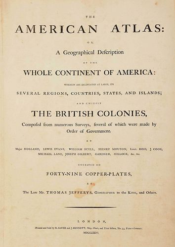
Thomas Jefferys - The American Atlas
About Seller
PO Box 2135
Asheville, NC 28802
United States
Based in Asheville, North Carolina, Brunk Auctions has been conducting sales of fine and decorative arts for over 30 years. Auctions are held in our North Carolina sale room but attracts a global audience. Founded by Robert Brunk in 1983, the auctions became well known for their integrity and profes...Read more
Two ways to bid:
- Leave a max absentee bid and the platform will bid on your behalf up to your maximum bid during the live auction.
- Bid live during the auction and your bids will be submitted real-time to the auctioneer.
Bid Increments
| Price | Bid Increment |
|---|---|
| $0 | $25 |
| $100 | $50 |
| $1,000 | $100 |
| $2,000 | $200 |
| $3,000 | $250 |
| $5,000 | $500 |
| $10,000 | $1,000 |
| $20,000 | $2,000 |
| $50,000 | $5,000 |
| $100,000 | $10,000 |
About Auction
Nov 12, 2022
Premier Auction - November 12, 2022 - Lots 622-926 Auction Begins | 9:00AM EST including Southern; Property from an Important Boston Collection; Important Maps; American; Coins; Firearms & Swords Brunk Auctions support@brunkauctions.com
- Lot Description
(British, 1719-1771)
23 maps comprised of 49 copper plates, on 30 sheets, from The American Atlas; or, a Geographical Description of the Whole Continent of America; Wherein are Delineated at Large its Several Regions, Countries, States, and Islands; and Chiefly the British Colonies..., printed and sold for Robert Sayer and John Bennet, London, 1776, includes letterpress title page and index leaf, and several distinguished maps including Jonathan Carver's A New Map of the Province of Quebec, Joshua Fry and Peter Jefferson's A Map of the Most Inhabited Part of Virginia, and Braddock Meade's A Map of the Most Inhabited Parts of New England, many are folding, engraved and hand colored in outline on laid paper, Strasbourg lily watermark with "LVG", bound within original marbled boards, with calf backstrip and gilt lettering to style, folio approximately 21-3/4 x 15-1/2 in.; book 22 x 16-1/4 in.; with a custom walnut and plexiglass stand, "Southampton" label to center drawer interior; 37 x 58-1/2 x 28 in.; accompanied by a detailed write-up from Cohen & Taliaferro LLC, New York, NY
Note:
Jefferys, the most renowned cartographer of the 18th century, was Geographer to the Prince of Wales, and later, Geographer to King George III. His well-placed position allowed him access to some of the most detailed and accurate surveys of America. After his death in 1771, his business partner, Robert Sayer, along with John Bennett, worked to accumulate the separately issued maps and republished them in 1776 as one comprehensive atlas of the American continent.
Walter Ristow (American, 1908-2006), former Chief of the Geography and Map Division at the Library of Congress, Washington, D.C., described Jefferys' atlas as a "geographical description of the whole continent of America, as portrayed in the best available maps in the later half of the eighteenth century ... as a major cartographic work it was, very likely, consulted by American, English, and French civilian administrators and military officers during the Revolution." [excerpt from Cohen & Taliaferro LLC write-up accompanied with atlas.]
Ristow's assumption is confirmed. Sir Henry Clinton, a British Commander in America during the Revolution, possessed five of the twenty-three maps detailed in Jefferys' atlas: maps nos. 7, 10, 18, 19, 23, and 24. (Listed as maps nos. 4, 6, 14, 15, and 18 from Cohen & Taliaferro LLC.)
To further confirm Ristow?s hypothesis, "In 1780, Thomas Jefferson wrote to General Horatio Gates, 'we are endeavouring to get you a copy of Fry & Jefferson's; but they are now very scarce.'" The Fry & Jefferson's map that Jefferson refers to is the [Map of the Most Inhabited Part of Virginia, Containing the Whole Province of Maryland...], maps no. 21,22 in Thomas Jefferys atlas. (Listed as map no. 17 from Cohen & Taliaferro LLC.)
Provenance: Cohen & Taliaferro, LLC, New York, NY; Private Virginia Collection
Condition
map of Northern Ocean with small repair to lower right margin and small area of repair on map crease margin; possible repair on map of The Pacific Ocean near guard; small area of repair on map of The Southern Ocean with small repair near guard; map An Accurate Map of North America possibly trimmed (although, entire map is present, but possibly missing some map elements beyond the neatline) with small repair near guard and small area of repair on top left margin; map Province of New Hampshire with repair to right and bottom margins; map An Exact Chart of the River St. Laurence with small repair near guard; map The Provinces of New York and New Jersey with repair to right margin and top corner and some possible retouch in pen and ink; map A Survey of Lake Champlain with small repair near guard; map A General Chart of the Island of Newfoundland possibly trimmed (although, entire map is present, but missing some map elements, such as longitudinal numbers, beyond the neatline); map An Accurate Map of North and South Carolina with repair along the right and bottom margin, with small areas of retouch in pen and ink; map The Western or Atlantic Ocean with repair to right margin with small area of retouch with pen and ink; map A Map of South America with small repair to bottom margin; other minor professional repairs, other possible trimmed edges (although maps include entire copper plate impression), some pencil inscriptions, light toning and foxing, some stains, some print bleed through, creases, small tears, and other typical surface wear consistent with age and use; stand in overall good condition, some minor wear, missing drawer key, minor scratches to plexiglass
- Shipping Info
-
Purchased items will be available for pick up or shipping from our Asheville, North Carolina auction facility within ten business days of the auction will be assessed a storage fee of $5.00 per day, per item. Purchaser agrees that packing and shipping is done at the purchaser's risk and that the purchaser will pay in advance all packing expenses, materials, carrier fees and insurance charges. At our discretion, items will either be packed by an agent such as a packaging store or Brunk Auctions. Please allow two weeks for shipping after payment is received. Shipment of large items is the responsibility of the purchaser. We are happy to provide names of carriers and shippers if a purchaser so requests. Brunk Auctions will have no liability for any loss or damage to shipped items.
-
- Payment & Auction Policies
-
Available payment options
-
-
- Buyer's Premium


 EUR
EUR CAD
CAD AUD
AUD GBP
GBP MXN
MXN HKD
HKD CNY
CNY MYR
MYR SEK
SEK SGD
SGD CHF
CHF THB
THB


