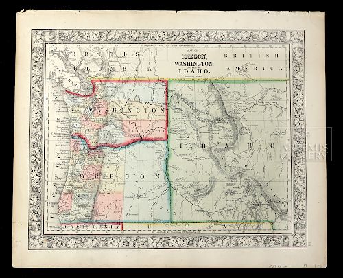
Mitchell Map of Oregon, Washington & Part of Idaho 1860
Lot 149
About Seller
Artemis Gallery
686 S Taylor Ave, Ste 106
Louisville, CO 80027
United States
Selling antiquities, ancient and ethnographic art online since 1993, Artemis Gallery specializes in Classical Antiquities (Egyptian, Greek, Roman, Near Eastern), Asian, Pre-Columbian, African / Tribal / Oceanographic art. Our extensive inventory includes pottery, stone, metal, wood, glass and textil...Read more
Categories
Estimate:
$200 - $300
Absentee vs Live bid
Two ways to bid:
- Leave a max absentee bid and the platform will bid on your behalf up to your maximum bid during the live auction.
- Bid live during the auction and your bids will be submitted real-time to the auctioneer.
Bid Increments
| Price | Bid Increment |
|---|---|
| $0 | $25 |
| $300 | $50 |
| $1,000 | $100 |
| $2,000 | $250 |
| $5,000 | $500 |
| $10,000 | $1,000 |
| $20,000 | $2,500 |
| $50,000 | $5,000 |
| $100,000 | $10,000 |
| $200,000 | $20,000 |
About Auction
By Artemis Gallery
May 24, 2018
Set Reminder
2018-05-24 10:00:00
2018-05-24 10:00:00
America/New_York
Bidsquare
Bidsquare : Northwest Coast, Tribal, & Pre-Columbian Art
https://www.bidsquare.com/auctions/artemis-gallery/northwest-coast-tribal-pre-columbian-art-3238
Featuring Pacific Northwest Coast Native American Art from respected collector / dealer, Joseph Alphabet. Artemis Gallery info@artemisgallery.com
Featuring Pacific Northwest Coast Native American Art from respected collector / dealer, Joseph Alphabet. Artemis Gallery info@artemisgallery.com
- Lot Description
Samuel Augustus Mitchell (American, 1790-1868), "Map of Oregon, Washington, and part of Idaho." 1860. A beautiful antique, hand-colored and engraved map that depicts Oregon just after it had become a state and Washington and Idaho - which were still regarded as Washington Territory until 1889 and 1890. that shows roads, counties, major towns, bodies of water, railroads, mining activity, land and coastal features, and military posts. A very collectible map showing the West as it was developing and taking shape during the era of Manifest Destiny, with boundaries that are very different from the ones we know today. The lovely decorative border is characteristic of this early period and features an intricate floral pattern. Size: 15.25" W x 12.75" H (38.7 cm x 32.4 cm)
Text below reads, "Entered according to Act of Congress, in the year 1860 by S. Augustus Mitchell, Jr. in the Clerks Office of the District Court of the U.S. for the Eastern District of Pennsylvania." In right margin: "44."
The first gold rush in this region occurred at Josephine Creek in Southwest Oregon in 1850 and 1851. However, gold was first discovered in Washington and Idaho in 1860. Indeed Idaho's Clearwater Gold Rush and Washington's Fort Colville Gold Rush near Colville, Washington occurred in 1860 - just at the time of this map's publication. Miners inundated these western lands, and the population doubled as the new settlers sought their fortune.
Dissatisfied with what school maps were available, Samuel Augustus Mitchell (1792-1868) became a mapmaker in the 1830s. In time he created a map publishing business that would make him and later his son among the most prominent American map publishers of the 19th century. Mitchell collaborated with prominent mapmakers and expert engravers of the day, including James H. Young and Henry S. Tanner. In this way, Mitchell ensured that his maps were of the utmost quality. During the 1850s, Mitchell partnered with Thomas, Cowperthwait, & Company to publish his "A New Universal Atlas and his General Atlas". In 1860, his son Samuel Augustus Mitchell Jr. inherited the Mitchell Company from his father. Among the pioneers of engraving on steel plates, the company specialized in school atlases and wall maps of America for more than thirty years.
Provenance: private Colorado, USA Collection
All items legal to buy/sell under U.S. Statute covering cultural patrimony Code 2600, CHAPTER 14, and are guaranteed to be as described or your money back.
A Certificate of Authenticity will accompany all winning bids.
We ship worldwide and handle all shipping in-house for your convenience.
#134546Expected nicks and creases to upper edge commensurate with age - with acid free tape on verso. Tiny tear to right margin that does not interfere with the imagery. Slight toning to border. Some foxing on verso. Hand-coloring is vibrant and details are very vivid. Inventory notes handwritten in pencil on lower right margin.Condition
- Shipping Info
-
All shipping is handled in-house for your convenience. Your invoice from Artemis Gallery will include shipping calculation instructions. If in doubt, please inquire BEFORE bidding for estimated shipping costs for individual items.
-
- Buyer's Premium


 EUR
EUR CAD
CAD AUD
AUD GBP
GBP MXN
MXN HKD
HKD CNY
CNY MYR
MYR SEK
SEK SGD
SGD CHF
CHF THB
THB


