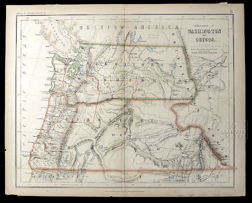
Map of Washington & Oregon Territories, 1857
Lot 302
About Seller
Artemis Fine Arts
686 S Taylor Ave, Ste 106
Louisville, CO 80027
United States
Selling antiquities, ancient and ethnographic art online since 1993, Artemis Gallery specializes in Classical Antiquities (Egyptian, Greek, Roman, Near Eastern), Asian, Pre-Columbian, African / Tribal / Oceanographic art. Our extensive inventory includes pottery, stone, metal, wood, glass and textil...Read more
Estimate:
$350 - $525
Absentee vs Live bid
Two ways to bid:
- Leave a max absentee bid and the platform will bid on your behalf up to your maximum bid during the live auction.
- Bid live during the auction and your bids will be submitted real-time to the auctioneer.
Bid Increments
| Price | Bid Increment |
|---|---|
| $0 | $25 |
| $300 | $50 |
| $1,000 | $100 |
| $2,000 | $250 |
| $5,000 | $500 |
| $10,000 | $1,000 |
| $20,000 | $2,500 |
| $50,000 | $5,000 |
| $100,000 | $10,000 |
| $200,000 | $20,000 |
About Auction
By Artemis Fine Arts
Aug 16, 2018
Set Reminder
2018-08-16 10:00:00
2018-08-16 10:00:00
America/New_York
Bidsquare
Bidsquare : Clearance Sale - Ancient / Ethnographic Art
https://www.bidsquare.com/auctions/artemis-gallery/clearance-sale---ancient-ethnographic-art-3368
These lots are going, going, gone... plus a nice selection of lots brand-new to auction! Artemis Fine Arts info@artemisgallery.com
These lots are going, going, gone... plus a nice selection of lots brand-new to auction! Artemis Fine Arts info@artemisgallery.com
- Lot Description
**Originally Listed At $200**
Henry Darwin Rogers (American, 1808-1866) & Alexander Keith Johnston (Scottish, 1804-1871), "Territories of Washington and Oregon." London: publisher Edward Stanford (British, 1827-1904). 1857. Drawn and engraved by Johnston. Hand colored with full and outline color. Territories in outline color with proposed railways in purple and counties in orange. A very rare map depicting the Oregon and Washington Territory, from Rogers and Johnston's "Atlas of the United States. An essential map for Oregon, Washington, Idaho and Montana collectors. Size: 16" W x 13" H (40.6 cm x 33 cm); 18" W x 14.25" H (45.7 cm x 36.2 cm) including margins
The map shows both territories extending to the Rocky Mountains, with only a few counties East of the Cascades. In addition, several early routes, major mountain elevations, and numerous early forts are shown - i.e. Fort Hall, Cantonment Loring, Ft. Boise, Fort Wahlah Wahlah, Ft Colville, Ft. Okinakane, and more. Intriguing early nature sights such as Priest's Rapids, American Falls, Three Tetons, Thompson's Rapids, Ross Rapids, Mt. Ranier, Mt. Adams, The Dalles, Ft. Niqually, Cowling Landing, and many others are also notes. What's more, the map names quite a few passes and provides a superb topographical treatment of the region. Also, the mining regions - Indian Agency Mine and Independence Mine - are named In Jackson County Oregon.
The Atlas in which this map appeared represented a highly unusual collaboration between a Scotsman (Johnston), an American (Rogers), and an Englishman (Stanford). The maps were all on a scale of 54.5 miles to one inch, and were derived from the large "Map of The United States, British & Central America", by Rogers and Johnston, 1857. The western U.S. maps presented the routes of the proposed Pacific Railroad. Johnston skillfully drew and engraved the mapsMinor toning. A few minute tears/losses to edges as shown. Some acid-free tape affixed to verso. Inventory notes written in pencil on lower right.Condition
- Shipping Info
-
All shipping is handled in-house for your convenience. Your invoice from Artemis Gallery will include shipping calculation instructions. If in doubt, please inquire BEFORE bidding for estimated shipping costs for individual items.
-
- Buyer's Premium


 EUR
EUR CAD
CAD AUD
AUD GBP
GBP MXN
MXN HKD
HKD CNY
CNY MYR
MYR SEK
SEK SGD
SGD CHF
CHF THB
THB


