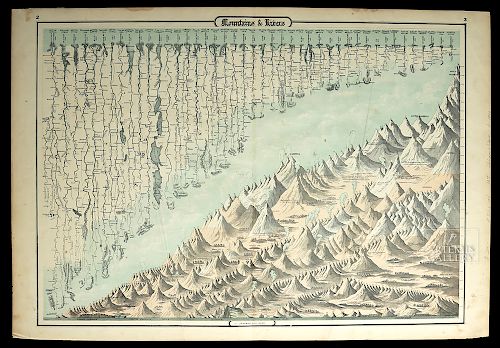
Johnson and Ward Mountains and Rivers Map, 1860's
Lot 138
About Seller
Artemis Gallery
686 S Taylor Ave, Ste 106
Louisville, CO 80027
United States
Selling antiquities, ancient and ethnographic art online since 1993, Artemis Gallery specializes in Classical Antiquities (Egyptian, Greek, Roman, Near Eastern), Asian, Pre-Columbian, African / Tribal / Oceanographic art. Our extensive inventory includes pottery, stone, metal, wood, glass and textil...Read more
Categories
Estimate:
$200 - $300
Absentee vs Live bid
Two ways to bid:
- Leave a max absentee bid and the platform will bid on your behalf up to your maximum bid during the live auction.
- Bid live during the auction and your bids will be submitted real-time to the auctioneer.
Bid Increments
| Price | Bid Increment |
|---|---|
| $0 | $25 |
| $300 | $50 |
| $1,000 | $100 |
| $2,000 | $250 |
| $5,000 | $500 |
| $10,000 | $1,000 |
| $20,000 | $2,500 |
| $50,000 | $5,000 |
| $100,000 | $10,000 |
| $200,000 | $20,000 |
About Auction
By Artemis Gallery
May 24, 2018
Set Reminder
2018-05-24 10:00:00
2018-05-24 10:00:00
America/New_York
Bidsquare
Bidsquare : Northwest Coast, Tribal, & Pre-Columbian Art
https://www.bidsquare.com/auctions/artemis-gallery/northwest-coast-tribal-pre-columbian-art-3238
Featuring Pacific Northwest Coast Native American Art from respected collector / dealer, Joseph Alphabet. Artemis Gallery info@artemisgallery.com
Featuring Pacific Northwest Coast Native American Art from respected collector / dealer, Joseph Alphabet. Artemis Gallery info@artemisgallery.com
- Lot Description
Johnson (Alvin Jewitt Johnson, American, 1827-1884) and Benjamin P. Ward (American), "Mountains and Rivers" - Johnson’s Chart of Comparative Heights of Mountains and Lengths of Rivers of North America, South America, Asia, Africa, and Europe, ca. 1861 to 1865 CE. A hand-colored, antique chromolithograph map that shows the lengths of rivers and heights of mountain ranges for each continent, except Australia. "Mountains and Rivers" is a fascinating diagram that not only shows the comparative heights of mountains and lengths of rivers from all over the globe, but also includes fascinating details such as the mountain ranges from which the rivers originate, smoke clouds emerging from active volcanoes, icy glaciers, architecture, and even tiny trees that represent the various vegetation types - palm trees, deciduous and conifers. The coloring and detail are impressive; all is surrounded by a black line border. Size: 26.5" W x 18" H (67.3 cm x 45.7 cm)
A leader of the atlas publication industry for a quarter century, Alvin Jewitt (A.J.) Johnson (American, 1827-1884) was a successful mapmaker as well as a keen businessman. Johnson acquired a set of detailed plates from J.H. Colton, one of the most respected mapmakers of the century, around 1860, electing to use them to print the popular Johnson's "New Illustrated Family Atlas" (steel plate, first published in 1860). These maps are wonderful works of cartographic art and highly prized collectibles, beloved for their fine hand coloring and their great attention to detail.
Benjamin P. Ward was an American publisher who was best known for his partnership with A. J. Johnson. As discussed above, the Johnson firm published its first significant work, the "New Illustrated Family Atlas" in 1860. The first edition of that Atlas shows imprints in New York and Richmond, Virginia. However, in 1861, after the outbreak of the American Civil War, Johnson & Browning elected to abandon their Richmond location. Browning remained in Virginia, and in 1861, Ward purchased Browning’s portion of the firm. The 1863 issue of the Atlas was a compilation of older Johnson and Browning maps, updated 1862 Johnson and Ward maps, and newer 1863 maps with an updated border design. In essence, the 1864 issue of the Atlas is the first true Johnson and Ward atlas, with one more Johnson and Ward Atlas in 1865, after which Johnson became the sole publisher.
Provenance: private Colorado, USA collection
All items legal to buy/sell under U.S. Statute covering cultural patrimony Code 2600, CHAPTER 14, and are guaranteed to be as described or your money back.
A Certificate of Authenticity will accompany all winning bids.
We ship worldwide and handle all shipping in-house for your convenience.
#134541Centerfold crease. Additional fold-marks to left and right. Expected but minor tears/losses to the edges and paper shows normal discoloration and a few small stains. Otherwise, the map is in very good condition. Inventory notes handwritten in pencil on right margin.Condition
- Shipping Info
-
All shipping is handled in-house for your convenience. Your invoice from Artemis Gallery will include shipping calculation instructions. If in doubt, please inquire BEFORE bidding for estimated shipping costs for individual items.
-
- Buyer's Premium


 EUR
EUR CAD
CAD AUD
AUD GBP
GBP MXN
MXN HKD
HKD CNY
CNY MYR
MYR SEK
SEK SGD
SGD CHF
CHF THB
THB


